Area Overview for B19 3EL
Photos of B19 3EL


Area Information
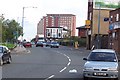
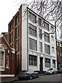
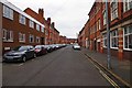
Living in B19 3EL means being part of a small, tightly knit residential cluster in the Newtown Ward of Birmingham. With a population of just 1,482, this area is defined by its post-war redevelopment, which transformed it into a hub of multi-storey flats and tower blocks. Situated north-west of Birmingham’s city centre, it borders the Jewellery Quarter, the University of Aston, and the Hockley Flyover. The area’s character is shaped by its history as an inner-city renewal project, with a focus on modernist housing rather than traditional architecture. Young adults dominate the population, with a median age of 22 and 21% of residents owning their homes. Daily life here is centred around nearby retail outlets, rail links, and the A34 road, which connects to Walsall and the city’s ring-road. While the area lacks green spaces, its proximity to Birmingham’s cultural and educational institutions offers opportunities for work and leisure. B19 3EL is not for those seeking a rural escape, but it provides a compact, accessible urban lifestyle with direct links to the city’s pulse.
- Area Type
- Postcode
- Area Size
- Not available
- Population
- 1482
- Population Density
- Not available
B19 3EL’s property market is heavily rental-focused, with only 21% of homes owned by residents. The area’s housing stock is almost entirely composed of flats, a legacy of its post-war redevelopment as a high-density residential zone. This makes it a less attractive option for buyers seeking owner-occupied properties, though it may appeal to investors looking for rental income. The limited number of owner-occupied homes suggests a transient population, with many residents moving in for short-term stays or to access nearby employment opportunities. The small size of the area means housing choices are constrained, and buyers may need to look beyond B19 3EL itself. For those considering the area, the flat-dominated market offers affordability but little scope for long-term equity growth. The proximity to Birmingham’s transport networks and institutions may offset this, but the lack of traditional housing types is a key consideration.
House Prices in B19 3EL
No properties found in this postcode.
Energy Efficiency in B19 3EL
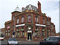
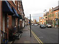
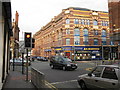
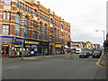
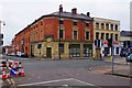
Life in B19 3EL is defined by proximity to Birmingham’s urban core and its infrastructure. The area’s rail and metro stations—such as St Paul’s and Bull Street—offer easy access to shopping, entertainment, and employment opportunities in the city. Nearby retail outlets like Morrisons Daily and Tesco Birmingham provide essential services, while the A34 road connects residents to Walsall and the city’s ring-road. The lack of parks or recreational spaces means leisure activities are likely to be centred on nearby venues, such as the Aston Hippodrome or The Drum Arts Centre, though these are not explicitly detailed in the data. The area’s post-war architecture and tower blocks create a distinct urban atmosphere, suitable for those prioritising convenience over traditional living. While the density of housing may feel cramped, the accessibility to Birmingham’s cultural and economic hubs makes it appealing for commuters and students.
Amenities
Schools
The only school listed near B19 3EL is Values Academy, a special school. No other educational institutions are detailed in the data, which means families relying on local schools may need to look further afield. Values Academy’s designation as a special school indicates it caters to students with specific educational needs, which may be a critical factor for some families. The absence of other schools, particularly primary or secondary institutions, suggests that B19 3EL is not a standalone option for families prioritising a range of local educational facilities. Residents may need to consider nearby wards or commute to schools in adjacent areas. This lack of diversity in school options could be a drawback for those seeking a comprehensive educational ecosystem within the immediate vicinity.
| Rank | School | Type | Entry gender | Ages |
|---|
Explore more schools in this area
Go to Schools tabDemographics
The community in B19 3EL is overwhelmingly young, with a median age of 22 and the majority of residents aged 15–29. This age group shapes the area’s dynamic, with a focus on affordability and proximity to urban amenities. Home ownership is low, at 21%, indicating that most residents rent their flats, which are the predominant type of accommodation. The demographic is largely White, though specific diversity statistics are not detailed. The high proportion of young adults suggests a transient population, with many likely to be students or early-career professionals. This profile influences the area’s character: social hubs are likely to be pubs or community centres rather than family-oriented spaces. The low home ownership rate also means the rental market dominates, with limited opportunities for long-term equity building. For those considering life here, the area offers a youthful, fast-paced environment but may lack the stability of more established communities.
Household Size
Accommodation Type
Tenure
Ethnic Group
Religion
Household Composition
Age
Household Deprivation
NS-SEC
Explore more demographic insights in this area
Go to Demographics tabPlanning
Planning Constraints
- Flood RiskPremium
- Ramsar Wetland SitesPremium
- Area of Outstanding Natural BeautyPremium
- Protected Nature ReservePremium
- Protected WoodlandPremium