Area Overview for B19 3EE
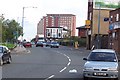
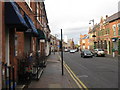
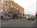
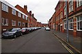
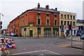
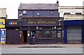
Photos of B19 3EE


Area Information
B19 3EE is a small residential postcode cluster in the heart of Birmingham’s Newtown Ward, also known as Aston New Town. Situated north-west of the city centre, it lies between the Jewellery Quarter, Hockley, and the University of Aston. The area is defined by its post-war redevelopment, which replaced older housing with tower blocks and multi-storey flats. With a population of 1,482, it is a compact, inner-city community characterised by a youthful demographic and proximity to key urban amenities. Residents benefit from being close to Birmingham’s transport networks, including major rail lines and metro stops, while the area’s history as a renewal zone means it is shaped by modernist architecture. Though small, B19 3EE sits at the edge of larger districts, offering a blend of urban connectivity and a distinct local identity. Its location near the A34 and A4540 roads ensures easy access to surrounding areas, making it a practical choice for commuters and those seeking affordability in Birmingham’s housing market.
- Area Type
- Postcode
- Area Size
- Not available
- Population
- 1482
- Population Density
- Not available
The property market in B19 3EE is heavily rental-focused, with only 21% of homes owned by residents. The accommodation type is exclusively flats, a direct result of the area’s post-war redevelopment, which prioritised high-density housing over traditional family homes. This makes the area more suited to younger residents or those seeking short-term housing solutions. The limited number of owner-occupied properties suggests a market where landlords dominate, potentially affecting affordability and long-term investment prospects. Given the small size of the postcode area, the housing stock is constrained, with little scope for new developments. Buyers considering the area should note that flats are the only available format, which may not appeal to those seeking larger or more traditional properties. The proximity to Birmingham’s transport networks and urban amenities may offset the lack of variety in housing types, but the limited supply means competition for available units is likely to be strong.
House Prices in B19 3EE
No properties found in this postcode.
Energy Efficiency in B19 3EE
Residents of B19 3EE have access to a range of practical amenities within walking or short-vehicle distance. The area is served by five retail outlets, including Morrisons Daily and two Tesco Birmingham locations, ensuring grocery and everyday shopping needs are met. Rail and metro stations provide easy access to Birmingham’s broader transport network, while the proximity to the A34 and A4540 roads facilitates travel to nearby districts. The area’s inner-city location means it lacks extensive green spaces, but its urban character offers convenience and proximity to cultural and commercial hubs. The presence of the A34 and surrounding transport infrastructure supports a lifestyle centred on connectivity and accessibility. While the data does not specify leisure or dining options, the area’s integration into Birmingham’s urban fabric suggests a range of off-site attractions, from restaurants to entertainment venues, are within reach.
Amenities
Schools
The nearest school to B19 3EE is Values Academy, a special school. No other schools are listed in the data, so families with children requiring mainstream education may need to look beyond the immediate area. The presence of a special school suggests the community may have a higher proportion of residents with specific educational needs or those seeking tailored support for children with additional requirements. However, the absence of primary or secondary schools in the data indicates that parents should investigate nearby options in surrounding wards. The lack of detailed information on school quality or Ofsted ratings means prospective residents should conduct further research to ensure alignment with their children’s educational needs.
| Rank | School | Type | Entry gender | Ages |
|---|
Explore more schools in this area
Go to Schools tabDemographics
B19 3EE has a median age of 22, with the majority of residents falling within the 15–29 age range. This reflects a young, dynamic population, likely drawn to the area for its affordability and proximity to Birmingham’s employment hubs. Home ownership is low, at just 21%, indicating that most residents are renters. The accommodation type is predominantly flats, a legacy of the post-war redevelopment that prioritised high-density housing. The predominant ethnic group is White, though specific data on diversity beyond this is not provided. The low home ownership rate and young age profile suggest a transient community, with residents possibly including students, young professionals, or those in temporary housing. This demographic profile shapes the area’s character, with social dynamics centred around shared living and community-driven initiatives. The lack of older households may also influence local services and amenities, which are tailored to younger, mobile populations.
Household Size
Accommodation Type
Tenure
Ethnic Group
Religion
Household Composition
Age
Household Deprivation
NS-SEC
Explore more demographic insights in this area
Go to Demographics tabPlanning
Planning Constraints
- Flood RiskPremium
- Ramsar Wetland SitesPremium
- Area of Outstanding Natural BeautyPremium
- Protected Nature ReservePremium
- Protected WoodlandPremium
- Crime RiskPremium