Area Overview for B19 3DF
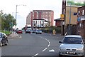
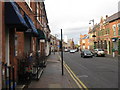
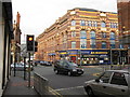
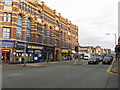
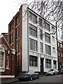
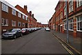
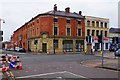
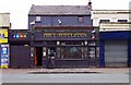
Photos of B19 3DF


Area Information
Living in B19 3DF means being part of a small, densely populated postcode area in the heart of Birmingham’s Newtown Ward. This inner-city location, centred on New Town Row, is bordered by historic districts like the Jewellery Quarter and the University of Aston. With a population of 1,482, it reflects the character of a post-war redevelopment area, dominated by tower blocks and multi-storey flats. Daily life here is shaped by proximity to major transport routes like the A34 and A4540, as well as railway stations such as Birmingham Snow Hill and Moor Street. The area’s young demographic—median age 22—suggests a community of students, young professionals, and families, with a strong presence of flats indicating a mix of rental and owner-occupied housing. While the area lacks green spaces, its connectivity to Birmingham’s infrastructure and amenities makes it a practical choice for those prioritising accessibility over rural tranquillity.
- Area Type
- Postcode
- Area Size
- Not available
- Population
- 1482
- Population Density
- 3933 people/km²
The property market in B19 3DF is characterised by a high proportion of rental properties, with only 21% of homes owner-occupied. The area’s housing stock is almost entirely flats, a direct result of the post-war redevelopment that prioritised high-density living. This makes the area more suited to renters than buyers, though the small postcode size means the immediate surroundings may offer similar housing stock. For buyers, the limited home ownership rate suggests a competitive market for flats, potentially with lower capital growth compared to areas with more owner-occupied properties. The presence of multi-storey blocks also means limited scope for property expansion or renovation. Prospective buyers should consider the area’s practicality for those needing short-term or flexible housing, rather than long-term investment.
House Prices in B19 3DF
No properties found in this postcode.
Energy Efficiency in B19 3DF
The lifestyle in B19 3DF is defined by proximity to urban amenities. Within reach are retail options like Morrisons Daily and Tesco Birmingham, offering everyday shopping convenience. The area’s transport links grant access to Birmingham’s cultural hubs, such as the Aston Hippodrome and The Drum Arts Centre, though these are not within the immediate postcode. Public transport hubs like Jewellery Quarter Railway Station and the metro stops at St Paul’s provide easy access to dining, entertainment, and employment opportunities. While the area lacks parks or open spaces, its density ensures a compact, efficient lifestyle for those prioritising connectivity over natural scenery.
Amenities
Schools
The nearest school to B19 3DF is Values Academy, a special school catering to students with specific educational needs. While no Ofsted rating is provided, the presence of a special school suggests the area serves a community with diverse educational requirements. Families seeking mainstream schooling may need to look beyond the immediate vicinity, as no other schools are listed in the data. The single school option highlights a potential limitation for parents prioritising a range of educational institutions, though the proximity to Birmingham’s larger schools via transport links could mitigate this.
| Rank | School | Type | Entry gender | Ages |
|---|---|---|---|---|
| 1 | Values Academy | special | N/A | N/A |
Explore more schools in this area
Go to Schools tabDemographics
B19 3DF has a median age of 22, with the majority of residents aged 15–29. This young demographic is reflected in the area’s 21% home ownership rate, which is notably low for a residential postcode, suggesting a rental market dominance. The accommodation type is predominantly flats, a legacy of the post-war redevelopment that replaced slum housing with high-density blocks. The predominant ethnic group is White, though specific diversity metrics are not provided. The area’s youth profile and flat-based housing indicate a transient population, with students and young workers forming a significant portion of the community. Lower home ownership may also reflect economic pressures or a preference for short-term tenancies, which could impact long-term stability for families.
Household Size
Accommodation Type
Tenure
Ethnic Group
Religion
Household Composition
Age
Household Deprivation
NS-SEC
Explore more demographic insights in this area
Go to Demographics tabPlanning
Planning Constraints
- Flood RiskPremium
- Ramsar Wetland SitesPremium
- Area of Outstanding Natural BeautyPremium
- Protected Nature ReservePremium
- Protected WoodlandPremium