Area Overview for B19 3AT
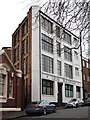
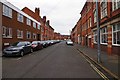
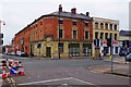
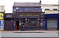
Photos of B19 3AT


Area Information
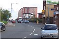
Living in B19 3AT means being part of a small, tightly knit residential cluster in the northwest of Birmingham. The postcode covers a compact area within Newtown Ward, historically known as Aston New Town, a post-war redevelopment project that shaped its identity. With a population of 1,968, it is a modest community centred on New Town Row, a stretch of the A34 road. The area’s character is defined by its legacy of tower blocks, remnants of 1960s urban planning, and its proximity to key transport routes like the A34 and A4540 ring-road. While the population is small, the area is connected to broader Birmingham through multiple railway stations, including Birmingham Snow Hill and Jewellery Quarter, and metro stops such as St Paul’s. Daily life here balances the convenience of urban connectivity with the challenges of inner-city living, where retail and leisure options are within reach but the community remains distinct in its demographics and history.
- Area Type
- Postcode
- Area Size
- Not available
- Population
- 1968
- Population Density
- Not available
The property market in B19 3AT is characterised by a low home ownership rate of 20%, meaning the majority of residents rent their homes. The accommodation type is almost exclusively flats, a direct result of the area’s post-war redevelopment into a tower block estate. This housing stock, originally comprising 16 high-rise blocks, now reflects a legacy of multi-storey living. While some blocks have been demolished, the remaining flats dominate the landscape, offering limited scope for owner-occupied properties. Buyers considering this area should expect a rental market with few opportunities for purchase, particularly within the small postcode itself. The surrounding areas may offer similar housing stock, but the immediate vicinity of B19 3AT is unlikely to provide significant alternative options for buyers seeking owner-occupied properties.
House Prices in B19 3AT
No properties found in this postcode.
Energy Efficiency in B19 3AT
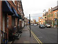
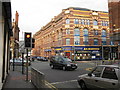
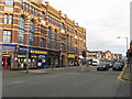
Life in B19 3AT is shaped by its proximity to retail, dining, and transport hubs. Within reach are major supermarkets like Tesco Birmingham and Morrisons Daily, providing everyday shopping convenience. The area’s transport links, including rail and metro stations, connect residents to Birmingham’s cultural and commercial centres, such as the Jewellery Quarter and the University of Aston. Historic venues like The Bartons Arms pub and The Drum Arts Centre offer local leisure options, while the legacy of the 1960s tower block estate remains a defining feature of the landscape. While the area lacks extensive parks or open spaces, its compact size ensures that amenities are accessible without long commutes. The mix of retail, transport, and cultural venues creates a functional, urban lifestyle, though the lack of green spaces may be a drawback for those seeking more natural environments.
Amenities
Schools
The nearest school to B19 3AT is St Francis Catholic Primary School, a primary school with a ‘good’ Ofsted rating. This single institution serves the area’s primary education needs, though no secondary schools are listed in the data. The presence of a ‘good’ rated primary school may be a key consideration for families, but the lack of secondary school options nearby could require commuting to other parts of Birmingham. The school’s rating suggests a satisfactory standard of education, but the absence of further details on school capacity or catchment areas means prospective residents should verify whether the school can accommodate their children.
| Rank | School | Type | Entry gender | Ages |
|---|
Explore more schools in this area
Go to Schools tabDemographics
The community in B19 3AT is predominantly composed of adults aged 30–64, though the median age is 22, reflecting a mix of younger and middle-aged residents. Home ownership is low, with only 20% of households owning their homes, indicating a rental-heavy market. The accommodation type is almost entirely flats, a legacy of the 1960s redevelopment that prioritised high-density housing. The predominant ethnic group is Black_total, highlighting the area’s cultural diversity. With a population of 1,968, the community is small but concentrated, shaped by historical redevelopment that replaced slum housing with tower blocks. This demographic profile suggests a population that may include younger families, professionals, and long-term residents navigating the challenges of limited home ownership and urban living.
Household Size
Accommodation Type
Tenure
Ethnic Group
Religion
Household Composition
Age
Household Deprivation
NS-SEC
Explore more demographic insights in this area
Go to Demographics tabPlanning
Planning Constraints
- Flood RiskPremium
- Ramsar Wetland SitesPremium
- Area of Outstanding Natural BeautyPremium
- Protected Nature ReservePremium
- Protected WoodlandPremium