Area Overview for B19 2YE
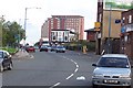
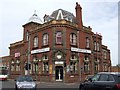
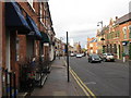
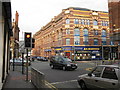
Photos of B19 2YE


Area Information
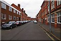
Living in B19 2YE means inhabiting a small residential cluster in the heart of Birmingham’s Newtown Ward, an area shaped by post-war redevelopment. With a population of 2,257, this inner-city postcode is characterised by a mix of modern infrastructure and historical layers. The area’s identity is rooted in its 1960s tower block estate, part of a large-scale renewal project that replaced slum housing and industrial sites. Today, it serves as a compact community with a median age of 47, where adults aged 30–64 form the majority. Proximity to transport networks, including rail and metro lines, and a range of retail and educational facilities make it practical for daily life. While the area lacks green spaces, its connectivity to Birmingham’s wider infrastructure—via roads like the A34 and rail services—ensures accessibility. Residents navigate a landscape of flats, with a strong rental market, and a community profile shaped by a predominantly Black population.
- Area Type
- Postcode
- Area Size
- Not available
- Population
- 2257
- Population Density
- 7772 people/km²
The property market in B19 2YE is heavily rental-focused, with only 16% of homes owned by residents. The area’s housing stock is dominated by flats, a legacy of its 1960s redevelopment as a tower block estate. This means the market is not geared toward owner-occupiers but rather tenants seeking affordable, practical housing. The small size of the postcode and its flat-dominated nature limit availability for buyers, making it a niche area for those prioritising proximity to transport and amenities over property value growth. For prospective buyers, the lack of detached or semi-detached homes and the prevalence of multi-storey blocks suggest a focus on short-term rental or investment opportunities. The area’s history of redevelopment also implies that any property in B19 2YE may require consideration of its structural and historical context, particularly given the demolition of some original tower blocks.
House Prices in B19 2YE
No properties found in this postcode.
Energy Efficiency in B19 2YE
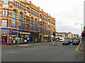
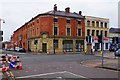
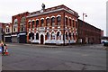
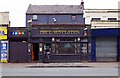
The lifestyle in B19 2YE is shaped by its urban setting and proximity to amenities. Within practical reach are five retail outlets, including Morrisons Select and Aldi Aston, providing daily essentials. Metro stations like St Paul’s and St Chads, along with rail services at Birmingham Snow Hill, offer easy access to the city. The area’s historical landmarks, such as The Bartons Arms and the defunct Aston Hippodrome, reflect its cultural heritage. While parks are not explicitly mentioned, the absence of planning constraints like AONB or protected woodlands suggests open spaces may be limited. Nonetheless, the cluster of shops, transport links, and cultural venues creates a convenient, though compact, environment for residents. The tower block estate remains a defining feature, blending practicality with the area’s post-war legacy.
Amenities
Schools
Residents of B19 2YE have access to three schools within practical reach. Chilwell Croft Primary School provides primary education, while Chilwell Croft Academy, an academy with a ‘good’ Ofsted rating, offers secondary schooling. For independent education, Newbury Independent School is available but holds an ‘inadequate’ Ofsted rating. This mix of school types offers families a range of options, from state-funded institutions to private alternatives, though the latter’s rating raises concerns about quality. The presence of a ‘good’ academy suggests strong secondary education, but parents should scrutinise the independent school’s performance. The proximity of these schools to the area underscores its appeal for families, though the adequacy of local education will depend on individual priorities and needs.
| Rank | School | Type | Entry gender | Ages |
|---|
Explore more schools in this area
Go to Schools tabDemographics
The community in B19 2YE is defined by its median age of 47, with adults aged 30–64 making up the largest demographic group. Home ownership is low, at 16%, indicating a rental-dominated market. The area is primarily composed of flats, reflecting its post-war housing stock. The predominant ethnic group is Black_total, which influences the cultural and social fabric of the neighbourhood. This demographic profile suggests a mature population with established ties to the area, though the low home ownership rate implies limited long-term investment in property. The absence of specific deprivation data means that quality of life considerations—such as access to services and safety—must be inferred from other metrics. For instance, the medium crime risk score (35/100) highlights the need for standard security measures, while the lack of environmental constraints like AONB or protected woodlands suggests minimal restrictions on development or land use.
Household Size
Accommodation Type
Tenure
Ethnic Group
Religion
Household Composition
Age
Household Deprivation
NS-SEC
Explore more demographic insights in this area
Go to Demographics tabPlanning
Planning Constraints
- Flood RiskPremium
- Ramsar Wetland SitesPremium
- Area of Outstanding Natural BeautyPremium
- Protected Nature ReservePremium
- Protected WoodlandPremium