Area Overview for B19 2RB
Photos of B19 2RB
Area Information
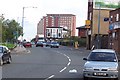
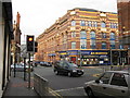
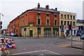
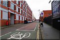
Living in B19 2RB means being part of a small, tightly knit residential cluster in the heart of Birmingham’s Newtown Ward. With a population of 2,124, the area is compact but strategically located, bordered by the Jewellery Quarter, Aston, and Lozells. Its character is shaped by post-war redevelopment, which saw the construction of tower blocks and multi-storey housing. This inner-city location offers proximity to Birmingham’s city centre, with easy access to major roads like the A34 and rail networks. Daily life here blends urban convenience with a distinct community feel, though the area’s history of slum housing and industrial use remains part of its legacy. Residents benefit from nearby retail, transport hubs, and schools, making it a practical choice for those seeking affordability and connectivity. However, the area’s housing stock reflects its past, with a mix of tower blocks and newer developments. For buyers, B19 2RB is a microcosm of Birmingham’s evolving urban landscape, where modern needs meet historical context.
- Area Type
- Postcode
- Area Size
- Not available
- Population
- 2124
- Population Density
- 9312 people/km²
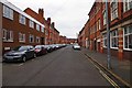
The property market in B19 2RB is dominated by rental properties, with only 36% of homes owned by residents. This suggests a strong presence of private landlords and a focus on rental affordability. The accommodation type is primarily houses, which is unusual for an area historically associated with tower blocks and high-density housing. This mix of housing styles may appeal to buyers seeking more space or a traditional home layout. However, the small size of the postcode area—covering a residential cluster rather than a large district—means the housing stock is limited. Buyers should consider the area’s proximity to Birmingham’s transport networks and schools, which may offset the lack of extensive property options. For those prioritising rental flexibility, B19 2RB offers a viable choice, though the low home ownership rate indicates that long-term investment may require careful consideration of market trends.
House Prices in B19 2RB
No properties found in this postcode.
Energy Efficiency in B19 2RB
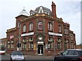
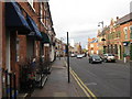
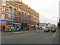
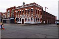
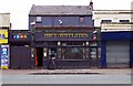
The lifestyle in B19 2RB is defined by its urban accessibility and practical amenities. Nearby retail options include Aldi Aston, Morrisons Select, and Morrisons Daily, offering everyday shopping needs within walking distance. The area’s transport links—rail, metro, and road networks—ensure residents can easily access Birmingham’s cultural and commercial hubs. While the area lacks extensive parks or leisure facilities, its proximity to the Jewellery Quarter and Aston provides access to historic sites, pubs like The Bartons Arms, and venues such as the Aston Hippodrome. The mix of retail, transport, and local landmarks creates a convenient, if compact, urban experience. For those who prioritise connectivity over sprawling green spaces, B19 2RB offers a lifestyle that balances practicality with the vibrancy of inner-city living.
Amenities
Schools
Residents of B19 2RB have access to two primary schools within practical reach: Lozells Junior and Infant School and Nursery, and Holte School. Both institutions hold a ‘good’ Ofsted rating, indicating a solid foundation for early education. The presence of two primary schools in the area provides families with options, though there is no mention of secondary schools nearby. This makes B19 2RB a suitable choice for families with young children but may require planning for secondary education elsewhere. The quality of these schools aligns with the area’s focus on practical living, offering a reliable start to a child’s education. However, the absence of higher-tier schools highlights a potential limitation for families requiring a full range of educational facilities.
| Rank | School | Type | Entry gender | Ages |
|---|---|---|---|---|
| 1 | Lozells Junior and Infant School and Nursery | primary | N/A | N/A |
| 2 | Holte School | primary | N/A | N/A |
| 3 | Mayfield School | special | N/A | N/A |
Explore more schools in this area
Go to Schools tabDemographics
B19 2RB has a median age of 22, but the most common age range for residents is 30–64 years. This suggests a community where younger people may be moving in or working in the area, while older adults form the core population. Home ownership is low at 36%, indicating that a significant portion of the housing stock is rented. The predominant accommodation type is houses, which is notable given the area’s history of high-rise developments. The predominant ethnic group is Asian_total, reflecting a diverse community. This diversity shapes the social fabric, with cultural influences evident in local businesses and community events. The area’s relatively small population of 2,124 means it is not densely packed, offering a quieter alternative to Birmingham’s more crowded districts. However, the low home ownership rate and reliance on rental properties suggest a transient population, which may impact the sense of long-term community stability.
Household Size
Accommodation Type
Tenure
Ethnic Group
Religion
Household Composition
Age
Household Deprivation
NS-SEC
Explore more demographic insights in this area
Go to Demographics tabPlanning
Planning Constraints
- Flood RiskPremium
- Ramsar Wetland SitesPremium
- Area of Outstanding Natural BeautyPremium
- Protected Nature ReservePremium
- Protected WoodlandPremium
- Crime RiskPremium