Area Overview for B19 2AE
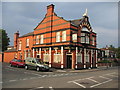
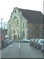
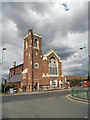
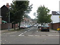
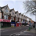
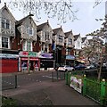
Photos of B19 2AE

Area Information
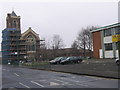
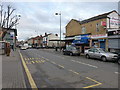
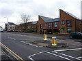
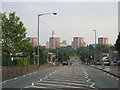
Living in B19 2AE, a small postcode area in West Birmingham, means being part of a densely populated urban neighbourhood with a distinct character. Situated between Handsworth and Aston, this area is centred on Lozells Road, within the Lozells and East Handsworth ward. With a population of 1,987, it reflects the inner-city dynamics of Birmingham, where Victorian terraced housing and post-war tower blocks coexist. The area’s history is marked by events such as the 1985 and 2005 riots, though today it is defined by its multi-ethnic community and proximity to key transport links. Residents here navigate a mix of local amenities, including retail outlets like Aldi Aston and Morrisons, alongside rail and metro stations that connect to the city’s broader network. While the area faces challenges linked to deprivation and unemployment, its residents benefit from strong digital connectivity and a relatively low crime risk. For those seeking a compact, connected urban environment, B19 2AE offers a blend of practicality and proximity to Birmingham’s cultural and economic hubs.
- Area Type
- Postcode
- Area Size
- Not available
- Population
- 1987
- Population Density
- 17789 people/km²
The property market in B19 2AE is characterised by a low home ownership rate of 37%, suggesting a significant portion of the housing stock is rented. The area is dominated by houses, though the small postcode area’s limited size means the housing stock is not extensive. Given the high proportion of rental properties, this may reflect both the economic pressures faced by residents and the lack of major employers in the vicinity. For buyers, the market is constrained by the area’s size and its status as a densely populated inner-city zone. While houses are the primary accommodation type, the lack of commercial or industrial development means property values are unlikely to be driven by economic growth. Prospective buyers should consider the area’s proximity to transport links and amenities, though the overall appeal may be tempered by the challenges of deprivation and limited local employment opportunities.
House Prices in B19 2AE
No properties found in this postcode.
Energy Efficiency in B19 2AE
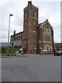
The lifestyle in B19 2AE is shaped by its proximity to retail outlets, transport hubs, and community spaces. Nearby shops include Aldi Aston and Morrisons Select, offering everyday essentials within walking distance. The area’s rail and metro stations, such as Perry Barr Railway Station and Soho Benson Road Metro, provide easy access to shopping, leisure, and employment opportunities across Birmingham. While parks and green spaces are not explicitly mentioned in the data, the presence of Lozells Methodist Church and community centres suggests a focus on social cohesion. The area’s character is defined by its mix of Victorian housing and modern amenities, creating a compact environment where daily life revolves around local services and transport connectivity. For residents, the convenience of nearby amenities balances the challenges of urban living.
Amenities
Schools
The only school explicitly listed near B19 2AE is Anglesey Junior School, a primary institution. No secondary schools or further education providers are mentioned in the data, which limits the range of educational options for families. The presence of a single primary school may require students to travel to nearby areas for secondary education, though the area’s proximity to rail and metro stations could ease this. The lack of detailed information on school performance or Ofsted ratings means potential residents must rely on local knowledge or additional research. For families prioritising a broad range of educational institutions, the absence of secondary schools in the immediate vicinity could be a consideration. However, the area’s connectivity to Birmingham’s transport network may mitigate this challenge.
| Rank | A + A* % | School | Type | Entry gender | Ages |
|---|---|---|---|---|---|
| 1 | N/A | Anglesey Junior School | primary | N/A | N/A |
Explore more schools in this area
Go to Schools tabDemographics
The demographic profile of B19 2AE is shaped by a median age of 22, though the most common age group is adults aged 30–64. Home ownership here is relatively low at 37%, with houses being the predominant type of accommodation. The area’s population is ethnically diverse, with the Asian community forming the largest proportion, surpassing the average for Birmingham. This diversity is reflected in the local character, where cultural influences permeate daily life. However, B19 2AE is among the UK’s 5% most deprived wards, ranking third in Birmingham’s 2019 Index of Multiple Deprivation. This highlights challenges such as higher unemployment rates and income deprivation, which impact access to services and opportunities. Despite this, the area’s young median age suggests a dynamic, working-age population, though the combination of low home ownership and deprivation indicates a reliance on rental housing and limited local economic activity.
Household Size
Accommodation Type
Tenure
Ethnic Group
Religion
Household Composition
Age
Household Deprivation
NS-SEC
Explore more demographic insights in this area
Go to Demographics tabPlanning
Planning Constraints
- Flood RiskLocked
- Ramsar Wetland SitesLocked
- Area of Outstanding Natural BeautyLocked
- Protected Nature ReserveLocked
- Protected WoodlandLocked
- Crime RiskLocked