Area Overview for B19 1DR
Photos of B19 1DR


Area Information
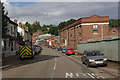
B19 1DR lies in the heart of Lozells, a tightly packed inner-city area in West Birmingham. This small postcode cluster, home to just 1,968 residents, sits between Handsworth and Aston, about 2 miles northwest of Birmingham’s city centre. The area is defined by its Victorian terraced housing, post-war tower blocks, and a mix of council properties, reflecting decades of urban development. Lozells has a complex history, marked by racial tensions and unrest, including riots in 1985 and 2005. Today, it remains a densely populated, ethnically diverse community, with Black residents forming the predominant group. While the area lacks major employers or commercial hubs, its proximity to rail networks and retail outlets like Tesco and Morrisons offers practical convenience. Living here means navigating a tight-knit, multi-ethnic neighbourhood with a strong sense of community, though challenges such as high deprivation and unemployment persist. The area’s compact size and proximity to Birmingham’s core make it a viable option for those prioritising connectivity over expansive space.
- Area Type
- Postcode
- Area Size
- Not available
- Population
- 1968
- Population Density
- Not available
The property market in B19 1DR is overwhelmingly rental-focused, with only 20% of homes owned by residents. The area is dominated by flats, reflecting its history of terraced and high-rise housing built to accommodate post-Industrial Revolution population growth. This limited stock of owner-occupied properties suggests a market skewed toward tenants, particularly in a small postcode area with constrained development potential. The prevalence of flats also means that buyers seeking larger homes or detached properties may find few options within the immediate vicinity. For those considering purchase, the area’s compact size and proximity to Birmingham’s transport networks could be advantages, though the high deprivation levels and lack of major employers may deter long-term investment. The housing stock, while functional, is largely older, with Victorian and post-war structures dominating. Buyers should weigh the practicality of rental availability against the area’s broader socioeconomic challenges.
House Prices in B19 1DR
No properties found in this postcode.
Energy Efficiency in B19 1DR
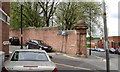
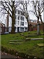
Daily life in B19 1DR revolves around its compact cluster of amenities, including retail outlets like Tesco Birmingham and Morrisons Daily, which provide essential shopping options. The area’s proximity to multiple railway stations and metro stops ensures easy access to Birmingham’s cultural and commercial hubs. The Lozells Methodist Church, a Grade II-listed building, serves as a community anchor, offering services and initiatives like a job club and soup kitchen. While the area lacks extensive parks or leisure facilities, its urban density fosters a sense of proximity to services and social spaces. The presence of institutions like St Francis Catholic Primary School and the historical Royal Oak pub adds to the local character. However, the limited economic opportunities and high deprivation levels mean that the lifestyle here is shaped more by necessity than luxury, with residents relying heavily on public transport and community resources.
Amenities
Schools
The only school explicitly listed near B19 1DR is St Francis Catholic Primary School, a primary institution with a ‘good’ Ofsted rating. This suggests a focus on early education, though no secondary schools are named in the data. Families relying on this single primary school may need to look beyond the immediate area for secondary options, potentially increasing travel time. The absence of additional schools in the data indicates limited local educational infrastructure, which could be a concern for parents seeking a range of school types. However, the presence of a ‘good’-rated primary school offers some reassurance for younger children. Given the area’s high deprivation levels, the quality of education may also be influenced by broader socioeconomic factors, though specific data on school performance beyond Ofsted ratings is not provided.
| Rank | School | Type | Entry gender | Ages |
|---|
Explore more schools in this area
Go to Schools tabDemographics
B19 1DR has a median age of 22, but the most common age range for residents is 30–64, indicating a mature adult population. Only 20% of households are owner-occupied, with flats being the primary accommodation type. The area’s demographic profile is shaped by high levels of deprivation, placing it among the UK’s 5% most deprived wards. This translates to limited economic opportunities and higher rates of income poverty. The predominant ethnic group is Black residents, reflecting the area’s historical and ongoing ties to migration and cultural diversity. The mix of Victorian housing and post-war flats suggests a long-standing working-class presence. While the population density is high, the community’s character is defined by its multi-ethnic composition and the presence of institutions like the Grade II-listed Lozells Methodist Church. For residents, this means a dynamic but challenging environment, where access to services and employment can be constrained by broader regional economic factors.
Household Size
Accommodation Type
Tenure
Ethnic Group
Religion
Household Composition
Age
Household Deprivation
NS-SEC
Explore more demographic insights in this area
Go to Demographics tabPlanning
Planning Constraints
- Flood RiskPremium
- Ramsar Wetland SitesPremium
- Area of Outstanding Natural BeautyPremium
- Protected Nature ReservePremium
- Protected WoodlandPremium