Area Overview for B19 1BB
Photos of B19 1BB
Area Information
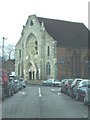
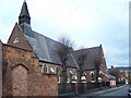
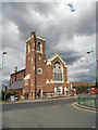
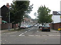
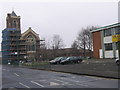
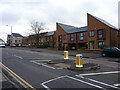
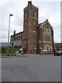
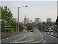
Living in B19 1BB, part of Lozells in West Birmingham, means being part of a small, densely populated residential cluster with a distinct urban character. This area lies between Handsworth and Aston, approximately 2 miles from Birmingham city centre, and is defined by its Victorian terraced housing, council properties, and post-war tower blocks. The community is multi-ethnic, with a high proportion of Afro-Caribbean, Bangladeshi, and Pakistani residents, reflecting broader trends in Birmingham’s diversity. Daily life here is shaped by proximity to transport networks, including five nearby rail and metro stations, and a mix of local amenities. While the area is among the UK’s most deprived, it also offers a sense of community through institutions like the Grade II-listed Lozells Methodist Church. Historical ties to industrial growth and civil unrest, such as the 1985 race riots, add layers to its identity. For homebuyers, B19 1BB presents a compact, accessible urban environment with a focus on affordability and proximity to essential services.
- Area Type
- Postcode
- Area Size
- Not available
- Population
- 1946
- Population Density
- 15299 people/km²
The property market in B19 1BB is characterised by a 51% home ownership rate, with houses being the primary accommodation type. This suggests a mix of owner-occupied properties and rental stock, though the exact balance of rental versus purchase is not specified. The prevalence of Victorian terraced housing and post-war tower blocks indicates a housing stock that is largely older and potentially more affordable than newer developments. Given the area’s deprivation status, property prices may reflect broader economic challenges in Birmingham’s inner-city zones. Buyers should consider the practical implications of this housing stock, including maintenance needs and potential limitations in property value growth. Proximity to transport links and schools may offset some of these factors, but the small size of the postcode area means that immediate surroundings are critical for assessing property opportunities.
House Prices in B19 1BB
No properties found in this postcode.
Energy Efficiency in B19 1BB
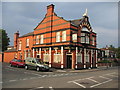
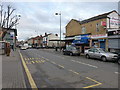
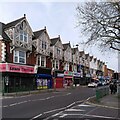
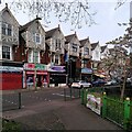
Residents of B19 1BB have access to a range of nearby amenities, including five retail outlets such as Aldi Aston, Morrisons Select, and Morrisons Daily. These stores provide essential shopping options for daily needs. The area’s transport links also grant proximity to Birmingham’s broader leisure and cultural offerings. While the data does not specify parks or recreational facilities, the presence of community hubs like the Lozells Methodist Church—offering services such as a job club and soup kitchen—highlights a focus on social support. The mix of retail, transport, and community resources creates a practical lifestyle, though the lack of detailed information on green spaces or dining options means buyers should investigate further for a full picture of the area’s amenities.
Amenities
Schools
Residents of B19 1BB have access to two primary schools: Anglesey Infant School and Anglesey Primary School. Both are primary institutions, with Anglesey Primary School holding a ‘good’ Ofsted rating. The presence of two primary schools within the area suggests a focus on early education, though no secondary schools are listed in the data. For families, this means a reliable foundation for younger children’s schooling, though parents may need to look further afield for secondary education. The ‘good’ rating at Anglesey Primary indicates a satisfactory standard of teaching and facilities, which is a positive factor for homebuyers prioritising education. However, the absence of secondary schools nearby could be a consideration for families planning long-term in the area.
| Rank | School | Type | Entry gender | Ages |
|---|---|---|---|---|
| 1 | Anglesey Infant School | primary | N/A | N/A |
| 2 | Anglesey Primary School | primary | N/A | N/A |
Explore more schools in this area
Go to Schools tabDemographics
B19 1BB has a population of 1,946, with a median age of 22, though the most common age range is adults aged 30–64. This suggests a mix of younger residents and families. Home ownership sits at 51%, with houses being the predominant accommodation type. The area’s demographic profile is marked by a high proportion of Asian residents, reflecting broader patterns in Birmingham. However, it also ranks among the UK’s 5% most deprived wards, with challenges such as high unemployment and income deprivation. This context influences the local economy, which lacks major employers or commercial hubs. Despite these factors, the community’s diversity and access to transport and schools create a dynamic environment. For buyers, understanding these figures is key to assessing both the area’s practicalities and its social fabric.
Household Size
Accommodation Type
Tenure
Ethnic Group
Religion
Household Composition
Age
Household Deprivation
NS-SEC
Explore more demographic insights in this area
Go to Demographics tabPlanning
Planning Constraints
- Flood RiskPremium
- Ramsar Wetland SitesPremium
- Area of Outstanding Natural BeautyPremium
- Protected Nature ReservePremium
- Protected WoodlandPremium
- Crime RiskPremium