Area Overview for B18 7NA
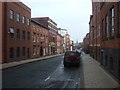
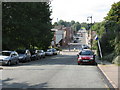
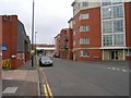
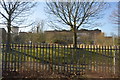
Photos of B18 7NA


Area Information
Living in B18 7NA means being part of a small, tightly knit residential cluster in central Birmingham, England. With a population of 2,097, this area is a microcosm of the broader Jewellery Quarter, a historic district renowned for its craftsmanship legacy. The area’s character blends 18th-century industrial heritage with modern innovation, from its Victorian architecture to contemporary retail and creative industries. Residents benefit from proximity to key landmarks like St Paul’s Church and the Museum of the Jewellery Quarter, which celebrates the district’s role as a World Craft City since 2025. Daily life here is shaped by a mix of heritage and practicality: the area’s compact size means amenities are within easy reach, while its location in Birmingham’s core offers access to transport networks and cultural hubs. The community, though small, reflects the diversity of the wider city, with a median age of 47 and a population skewed toward adults aged 30–64. For those seeking a balance between history and modern convenience, B18 7NA offers a distinctive blend of both.
- Area Type
- Postcode
- Area Size
- Not available
- Population
- 2097
- Population Density
- 3541 people/km²
The property market in B18 7NA is characterised by a 34% home ownership rate, with houses being the primary accommodation type. This suggests a modest market where owner-occupation is not the norm, and rental properties likely make up a significant share of the housing stock. The prevalence of houses may indicate a focus on family homes, though the small size of the area means the market is limited in scope. For buyers, this presents a challenge: the number of available properties is constrained, and competition may be fierce among those seeking to purchase. However, the area’s historical and cultural appeal could make it attractive to investors or buyers looking for a niche market. Proximity to transport links and amenities may also enhance its desirability, despite the limited scale of the housing stock.
House Prices in B18 7NA
No properties found in this postcode.
Energy Efficiency in B18 7NA
Residents of B18 7NA enjoy a lifestyle enriched by nearby amenities, from retail hubs to transport links. The area’s proximity to Tesco Hockley, Tesco Birmingham, and Lidl Winson ensures easy access to grocery shopping, while the nearby railway stations and metro stops provide seamless connections to Birmingham’s transport network. The presence of landmarks like St Paul’s Church and the Museum of the Jewellery Quarter adds cultural value, offering both historical insight and leisure opportunities. The compact nature of the area means that essential services are within walking or short-vehicle distance, fostering a sense of convenience. For those who enjoy a mix of heritage and modernity, the blend of Victorian architecture and contemporary retail spaces creates a unique living environment. The area’s small scale ensures a close-knit community feel, where daily life is shaped by accessibility and historical significance.
Amenities
Schools
Residents of B18 7NA have access to a range of educational institutions, including St Edmund’s Catholic Primary School, a primary school with no Ofsted rating listed, and City Hospital Teaching Unit, a special needs school. Two independent schools are also nearby: Future First Independent School, which has an Ofsted rating of inadequate, and Orion School, rated good. This mix of school types offers families options, though the presence of an inadequate-rated school may raise concerns. The independent schools cater to those seeking alternative education models, while the special needs school highlights the area’s capacity to support diverse educational needs. For parents prioritising high-quality education, Orion’s good rating is a positive, but the overall school landscape requires careful consideration of each institution’s performance.
| Rank | School | Type | Entry gender | Ages |
|---|
Explore more schools in this area
Go to Schools tabDemographics
The community in B18 7NA has a median age of 47, with the majority of residents falling within the 30–64 age range. This suggests a mature population, likely with established careers and family ties to the area. Home ownership rates stand at 34%, indicating a mix of owner-occupied properties and rental units. The predominant accommodation type is houses, which may reflect the area’s historical development as a residential district. The predominant ethnic group is Black residents, highlighting the area’s cultural diversity. While specific deprivation data is not provided, the relatively low home ownership rate could imply a higher proportion of renters, potentially affecting long-term stability for some households. The age profile and housing stock suggest a community focused on practical living, with a strong emphasis on family-oriented environments.
Household Size
Accommodation Type
Tenure
Ethnic Group
Religion
Household Composition
Age
Household Deprivation
NS-SEC
Explore more demographic insights in this area
Go to Demographics tabPlanning
Planning Constraints
- Flood RiskPremium
- Ramsar Wetland SitesPremium
- Area of Outstanding Natural BeautyPremium
- Protected Nature ReservePremium
- Protected WoodlandPremium