Area Overview for B18 6HS
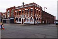
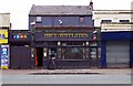
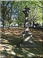
Photos of B18 6HS

Area Information
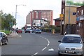
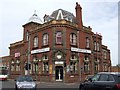
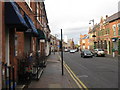
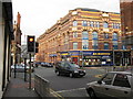
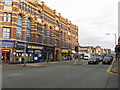
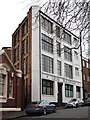
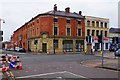
Living in B18 6HS means inhabiting a compact residential cluster in central Birmingham, England, where history and modernity intersect. The area, part of the broader Jewellery Quarter Improvement District, is steeped in industrial legacy, once a global hub for jewellery manufacturing. Today, it retains its Victorian and Edwardian architectural character, with streets like Warstone Lane preserving this heritage. The postcode covers 87 m² and is densely populated, with 1,482 residents per square kilometre. Despite its small size, the area is rich in cultural and economic significance, having earned World Craft City status in 2025. Daily life here is shaped by proximity to historic landmarks such as St. Paul’s Church and the Museum of the Jewellery Quarter, alongside a vibrant mix of retail and transport links. The community, predominantly young adults aged 15–29, reflects a dynamic, evolving demographic. While the area’s compact nature limits expansion, its strategic location near Birmingham’s central rail and metro networks ensures connectivity to the city’s broader amenities. For those seeking a blend of heritage, convenience, and urban energy, B18 6HS offers a distinct slice of Birmingham’s character.
- Area Type
- Postcode
- Area Size
- 87 m²
- Population
- 1482
- Population Density
- 3933 people/km²
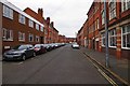
The property market in B18 6HS is characterised by a low home ownership rate of 21%, suggesting that the majority of residents rent rather than own their homes. This statistic points to a rental-dominated market, likely influenced by the area’s compact size and high population density. The accommodation type is predominantly flats, reflecting the limited space available in this small postcode. This housing stock is typical of urban centres, where high demand for proximity to amenities and transport networks drives rental demand. For buyers, the small area and surrounding cluster imply that property options are constrained, with limited scope for expansion or redevelopment. The prevalence of flats may also mean that larger family homes are scarce, potentially limiting appeal for those seeking more space. However, the area’s historical significance and connectivity to Birmingham’s central districts could make it attractive for investors or those prioritising location over property size.
House Prices in B18 6HS
No properties found in this postcode.
Energy Efficiency in B18 6HS
Life in B18 6HS is shaped by its proximity to Birmingham’s central amenities, with retail, transport, and cultural hubs within easy reach. The area’s railway stations, including Jewellery Quarter and Birmingham Moor Street, provide direct links to major destinations, while metro stops like Centenary Square offer swift access to the city’s landmarks. Retail options are diverse, with Tesco Birmingham and Morrisons Daily ensuring convenience for daily shopping. The historic character of the Jewellery Quarter adds a unique dimension, with landmarks such as St. Paul’s Church and the Museum of the Jewellery Quarter offering cultural enrichment. Despite its small size, the area’s density fosters a compact, walkable environment where amenities are closely clustered. This blend of practicality and heritage creates a lifestyle that balances urban convenience with historical resonance.
Amenities
Schools
The nearest school to B18 6HS is Values Academy, a special school catering to students with specific educational needs. No other schools are listed in the data, meaning families relying on mainstream education may need to look beyond the immediate area. The presence of a special school highlights the area’s focus on inclusive education but does not provide information on the availability of primary or secondary schools. For families seeking a range of educational options, the lack of nearby mainstream schools could be a concern, requiring reliance on transport links to broader Birmingham districts. This limitation may impact the area’s appeal for households prioritising proximity to a comprehensive school network.
| Rank | School | Type | Entry gender | Ages |
|---|
Explore more schools in this area
Go to Schools tabDemographics
The population of B18 6HS is 1,482, with a median age of 22, indicating a community dominated by young adults aged 15–29. Only 21% of residents own their homes, suggesting a rental-heavy market, while flats are the predominant accommodation type. The majority of the population identifies as White, reflecting the area’s historical and cultural roots. This demographic profile implies a transient or student-oriented population, with limited long-term housing stability. The high proportion of young adults may influence local services and amenities, shaping a social environment centred on shared living and community engagement. However, the low home ownership rate could indicate challenges in property affordability or a preference for rental flexibility. The area’s compact size and dense population also mean limited space for family-oriented housing, which may affect the appeal for larger households. These factors collectively define a community in flux, shaped by economic opportunities and historical legacies.
Household Size
Accommodation Type
Tenure
Ethnic Group
Religion
Household Composition
Age
Household Deprivation
NS-SEC
Explore more demographic insights in this area
Go to Demographics tabPlanning
Planning Constraints
- Flood RiskPremium
- Ramsar Wetland SitesPremium
- Area of Outstanding Natural BeautyPremium
- Protected Nature ReservePremium
- Protected WoodlandPremium