Area Overview for B18 6AS
Photos of B18 6AS


Area Information
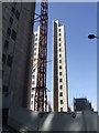
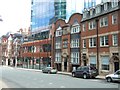
Living in B18 6AS means being part of a small, tightly knit residential cluster in central Birmingham, where history and modernity intersect. With a population of 1,482, this area is compact yet rich in heritage, situated within the broader Jewellery Quarter Improvement District. Once a global hub for jewellery manufacturing, the area retains its 18th-century industrial character, with Victorian and Edwardian architecture lining streets like Warstone Lane. Today, it blends this legacy with contemporary retail, creative industries, and a growing focus on heritage tourism. The area is young, with a median age of 22, and predominantly populated by individuals aged 15–29. Daily life is shaped by proximity to rail networks, retail hubs, and cultural landmarks such as St. Paul’s Church and the Museum of the Jewellery Quarter. While the community is small, it is connected to Birmingham’s wider infrastructure, offering access to major transport routes and a mix of specialist shops and services. Living here suits those who value a compact, historically significant environment with practical amenities nearby.
- Area Type
- Postcode
- Area Size
- Not available
- Population
- 1482
- Population Density
- 3933 people/km²
The property market in B18 6AS is characterised by a low rate of home ownership, with only 21% of residents owning their homes. This suggests that the area is predominantly a rental market, with flats making up the majority of accommodation types. The prevalence of flats indicates a focus on smaller, urban living spaces, often suited to individuals or couples rather than larger families. For buyers, this means limited availability of owner-occupied properties, which may make the area more attractive to investors or those seeking short-term rental opportunities. The compact nature of the postcode, combined with its proximity to Birmingham’s central amenities, could make it a strategic choice for those prioritising location over long-term ownership. However, the low home ownership rate also highlights the area’s role as a transient hub, where residents may move frequently in response to employment or educational pursuits.
House Prices in B18 6AS
No properties found in this postcode.
Energy Efficiency in B18 6AS
Residents of B18 6AS have access to a range of amenities within walking or short transit distance. Retail options include multiple Tesco and Morrisons stores, providing everyday shopping convenience. The area’s proximity to rail and metro stations, such as St Paul’s and Centenary Square, ensures easy access to Birmingham’s cultural and commercial centres. While specific parks or leisure facilities are not listed in the data, the area’s historic character includes landmarks like St. Paul’s Church and the Museum of the Jewellery Quarter, offering cultural enrichment. The compact layout and density of services suggest a lifestyle focused on efficiency and connectivity, with residents able to meet most needs without long commutes. The blend of heritage and modern infrastructure creates a dynamic environment that balances tradition with practicality.
Amenities
Schools
The nearest school to B18 6AS is Values Academy, a special school catering to students with specific educational needs. No other schools are listed in the data, meaning the area’s educational provision is limited to this single institution. Families with children requiring specialist education may find this school a critical resource, though it does not offer a broad range of school types such as primary or secondary institutions. The absence of additional schools suggests that residents may need to travel beyond the immediate area for broader educational options. This could be a consideration for families planning long-term stays or those prioritising a diverse range of schools for their children.
| Rank | School | Type | Entry gender | Ages |
|---|
Explore more schools in this area
Go to Schools tabDemographics
The population of B18 6AS is overwhelmingly young, with a median age of 22 and the majority of residents aged 15–29. This reflects a community shaped by students, young professionals, and those entering the workforce. Home ownership is low, with only 21% of households owning their homes, suggesting a rental-dominated market. The primary accommodation type is flats, indicating a focus on smaller, urban living spaces. The predominant ethnic group is White, though specific data on diversity beyond this is not provided. The age profile implies a dynamic, transient population, with lifestyle choices leaning towards flexibility and proximity to employment or education. This demographic also suggests a reliance on public transport and shared amenities, as seen in the area’s dense network of rail and metro stations. The low home ownership rate may impact long-term stability for some residents, but it also aligns with the area’s role as a hub for young, mobile populations.
Household Size
Accommodation Type
Tenure
Ethnic Group
Religion
Household Composition
Age
Household Deprivation
NS-SEC
Explore more demographic insights in this area
Go to Demographics tabPlanning
Planning Constraints
- Flood RiskPremium
- Ramsar Wetland SitesPremium
- Area of Outstanding Natural BeautyPremium
- Protected Nature ReservePremium
- Protected WoodlandPremium