Area Overview for B18 6AG
Photos of B18 6AG


Area Information
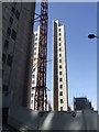
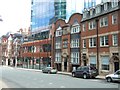
B18 6AG is a small residential postcode nestled in the Newtown Ward of Birmingham, historically known as Aston New Town. With a population of 1,482, it is a compact area defined by its post-war redevelopment, which saw the construction of tower blocks and multi-storey housing. Situated to the north-west of Birmingham’s city centre, it borders the Jewellery Quarter, Hockley, and the University of Aston. Daily life here is shaped by its inner-city location, with proximity to major transport routes like the A34 and A4540 ring-road. The area’s character is marked by its mix of modern flats and historic landmarks, such as The Bartons Arms pub. While the community is young, with a median age of 22, it is also diverse in its cultural makeup, though the predominant ethnic group remains White. Living in B18 6AG means navigating a dynamic urban environment with easy access to Birmingham’s economic and cultural hubs, though the area’s legacy of redevelopment continues to influence its social and physical landscape.
- Area Type
- Postcode
- Area Size
- Not available
- Population
- 1482
- Population Density
- 3933 people/km²
The property market in B18 6AG is overwhelmingly rental-focused, with only 21% of residents owning their homes. The area’s housing stock consists almost entirely of flats, a legacy of its post-war redevelopment as a high-density residential estate. This makes it a less attractive option for buyers seeking owner-occupied properties, particularly in a small postcode like B18 6AG where housing choices are limited. The prevalence of flats suggests a practical, no-frills approach to living, suited to those prioritising affordability and proximity to transport over spacious or traditional housing. For buyers, the area’s compact size and limited availability of owner-occupied homes mean competition may be fierce, and any property available is likely to be in high demand. The historical context of the estate also means that properties may require modernisation to meet current standards.
House Prices in B18 6AG
No properties found in this postcode.
Energy Efficiency in B18 6AG
The lifestyle in B18 6AG is shaped by its urban setting and proximity to retail, transport, and cultural amenities. Nearby shops include Tesco Birmingham, Morrisons Daily, and other retail outlets, offering convenience for daily errands. The area’s transport links, including rail and metro stations, provide easy access to Birmingham’s city centre, where more extensive leisure and dining options are available. Historically, the area has hosted venues like The Bartons Arms, a pub, and The Elbow Room, a nightclub, suggesting a lively social scene. However, the data does not mention parks or green spaces, which may be a consideration for those seeking outdoor recreation. Overall, the area offers a mix of practicality and urban vibrancy, though its density and lack of natural spaces may not appeal to everyone.
Amenities
Schools
The only school explicitly listed near B18 6AG is Values Academy, a special school. No other schools are mentioned in the data, which suggests that families may need to look beyond the immediate area for mainstream education options. The presence of a special school indicates that the area may cater to students with specific educational needs, but it does not provide a full range of school types for all age groups. For families requiring a broader selection of schools, including primary or secondary institutions, commuting to nearby wards or Birmingham’s city centre may be necessary. The lack of detailed information on school performance or Ofsted ratings means prospective residents should investigate further to assess whether the available education options meet their requirements.
| Rank | School | Type | Entry gender | Ages |
|---|
Explore more schools in this area
Go to Schools tabDemographics
B18 6AG has a median age of 22, with the majority of residents falling within the 15–29 age range. This indicates a community dominated by young adults, likely students or early-career professionals. Home ownership is low at 21%, suggesting that most residents are renters, a pattern common in post-war housing estates. The area is characterised by flats, reflecting its history of high-density redevelopment. The predominant ethnic group is White, though specific diversity data is not provided. The young demographic and low home ownership rate imply a transient population, which may affect community cohesion. For those considering living here, the area’s affordability and proximity to transport could be appealing, though the lack of long-term residency may mean a less established local culture compared to other parts of Birmingham.
Household Size
Accommodation Type
Tenure
Ethnic Group
Religion
Household Composition
Age
Household Deprivation
NS-SEC
Explore more demographic insights in this area
Go to Demographics tabPlanning
Planning Constraints
- Flood RiskPremium
- Ramsar Wetland SitesPremium
- Area of Outstanding Natural BeautyPremium
- Protected Nature ReservePremium
- Protected WoodlandPremium