Area Overview for B18 5SS
Photos of B18 5SS


Area Information
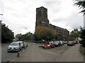
Living in B18 5SS places you in a small residential cluster within the historic Jewellery Quarter of Birmingham, a district renowned for its craftsmanship heritage. With a population of 2,785, this area blends compact living with proximity to cultural and industrial landmarks. The Jewellery Quarter, designated a World Craft City in 2025, offers a unique mix of historical significance and modern vibrancy. Residents benefit from being near key sites like St. Paul’s Church and the Birmingham Assay Office, while the area’s compact size fosters a tight-knit community. Daily life here is shaped by its industrial legacy, with streets like Warstone Lane preserving Victorian and Edwardian architecture. The postcode’s location ensures easy access to transport networks, retail hubs, and cultural institutions, making it appealing to those seeking a balance between heritage and convenience. However, its small size means the area is best suited for those prioritising proximity to amenities over expansive living spaces.
- Area Type
- Postcode
- Area Size
- Not available
- Population
- 2785
- Population Density
- 6348 people/km²
The property market in B18 5SS is characterised by a 30% home ownership rate, indicating that the majority of residents rent their homes. The predominant accommodation type is houses, which is unusual for urban areas and suggests a focus on family-friendly housing stock. This mix of owner-occupied and rental properties may appeal to buyers seeking larger homes, though the small area’s limited size means opportunities are constrained. The presence of houses rather than flats may also influence property values, with potential for investment in renovation or development. However, the low home ownership rate could signal a reliance on private rentals, which may affect affordability for first-time buyers. Prospective purchasers should consider the area’s compact nature and the potential for limited expansion in the immediate surroundings.
House Prices in B18 5SS
No properties found in this postcode.
Energy Efficiency in B18 5SS
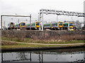
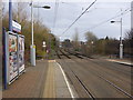
Residents of B18 5SS have access to a range of amenities within walking or short transit distance. Five Metro stops, including Soho Benson Road and Winson Green Outer Circle, facilitate easy movement around the area. Retail options such as Iceland Handsworth and Lidl Handsworth cater to everyday needs, while five rail stations, including Hawthorns Railway Station, connect to broader networks. The area’s proximity to the Jewellery Quarter also grants access to cultural landmarks like St. Paul’s Church and the Museum of the Jewellery Quarter. These amenities create a convenient lifestyle, blending practicality with historical interest. The mix of retail, transport, and cultural sites ensures that daily life here is both functional and enriched by the area’s heritage.
Amenities
Schools
The nearest school to B18 5SS is Greenspring Training, an independent institution. Independent schools often offer smaller class sizes and specialised curricula, though no Ofsted rating is provided in the data. The presence of a single school suggests limited options for families, but Greenspring Training’s status as an independent school may cater to specific educational preferences. For parents prioritising state education, the area’s proximity to the broader Jewellery Quarter may offer additional schools, though none are explicitly listed here. The school mix in B18 5SS is therefore skewed towards independent education, which could be a key consideration for families evaluating the area’s suitability for their children’s needs.
| Rank | School | Type | Entry gender | Ages |
|---|
Explore more schools in this area
Go to Schools tabDemographics
The population of B18 5SS has a median age of 22, though the most common age range is 30–64 years, indicating a mix of younger and middle-aged residents. Home ownership stands at 30%, suggesting a majority of households are renters. The accommodation type is predominantly houses, reflecting a residential character distinct from high-density housing. The predominant ethnic group is Black_total, highlighting the area’s diversity. While no specific deprivation data is provided, the 30% ownership rate may imply a reliance on rental markets, which can affect long-term stability for some residents. The age profile suggests a community with active professionals and families, though the younger median age may indicate a transient population. This demographic mix shapes a dynamic but potentially shifting social landscape.
Household Size
Accommodation Type
Tenure
Ethnic Group
Religion
Household Composition
Age
Household Deprivation
NS-SEC
Explore more demographic insights in this area
Go to Demographics tabPlanning
Planning Constraints
- Flood RiskPremium
- Ramsar Wetland SitesPremium
- Area of Outstanding Natural BeautyPremium
- Protected Nature ReservePremium
- Protected WoodlandPremium