Area Overview for B18 4PE
Photos of B18 4PE


Area Information
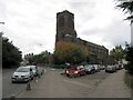
Living in B18 4PE means being part of a small, tightly knit residential cluster within Birmingham’s historic Jewellery Quarter. With a population of just 2,098, the area retains a quiet, community-focused character despite its proximity to the city’s bustling core. This postcode is part of a broader 300-acre improvement district, designated as a World Craft City in 2025 for its legacy in jewellery manufacturing. The area’s streets, like Warstone Lane and Vyse Street, preserve Victorian and Edwardian architecture, blending heritage with modern living. Residents benefit from proximity to landmarks such as St. Paul’s Church and the Museum of the Jewellery Quarter, which ranks among Europe’s top free attractions. Daily life here is shaped by a mature demographic, with a median age of 47 and a strong presence of Asian communities. While the area’s industrial past is evident in its craftsmanship legacy, its present offers a mix of historic charm and practical amenities, making it a niche choice for those seeking a unique urban lifestyle.
- Area Type
- Postcode
- Area Size
- Not available
- Population
- 2098
- Population Density
- 4173 people/km²
The property market in B18 4PE is defined by a low home ownership rate of 28%, suggesting that the majority of properties are rented rather than owner-occupied. The accommodation type is predominantly houses, which are less common in urban areas and may indicate a niche market for buyers seeking standalone homes. This small area’s limited housing stock means competition for available properties could be high, particularly for those prioritising owner-occupation. The presence of houses, rather than flats or apartments, may appeal to families or professionals seeking space and privacy. However, the low home ownership percentage implies that the area is not a traditional buyers’ market, with potential challenges in securing long-term property investment.
House Prices in B18 4PE
No properties found in this postcode.
Energy Efficiency in B18 4PE
Residents of B18 4PE have access to a range of amenities within practical reach, including five metro stations such as Winson Green Outer Circle and Soho Benson Road, which facilitate easy travel. Retail options include Lidl Winson, M&S Midland, and Iceland Handsworth, offering grocery and general shopping. The area’s rail connections, including Hawthorns Railway Station, provide links to Birmingham’s transport network. While the postcode’s small size limits the number of venues, its proximity to the historic Jewellery Quarter offers cultural and historical attractions. The blend of practical amenities and heritage sites creates a lifestyle that balances convenience with a sense of place.
Amenities
Schools
The nearest school to B18 4PE is Sporting Edge Independent School, an independent institution. No Ofsted rating is provided, but the presence of an independent school suggests a focus on private education options. This school type typically offers smaller class sizes and specialised curricula, which may appeal to families prioritising tailored learning environments. However, the lack of state school options in the data means families relying on public education may need to look beyond the immediate area. The single school listed highlights a limited selection, which could be a consideration for prospective residents with children.
| Rank | School | Type | Entry gender | Ages |
|---|
Explore more schools in this area
Go to Schools tabDemographics
The population of B18 4PE is 2,098, with a median age of 47, indicating a community dominated by adults aged 30–64. Home ownership here is relatively low at 28%, suggesting a rental-heavy market. The area is characterised by houses rather than flats, reflecting a preference for standalone properties. The predominant ethnic group is Asian, which shapes the cultural and social fabric of the neighbourhood. This demographic profile implies a stable, mature population with established ties to the area. The low home ownership rate may indicate a transient community or a reliance on rental properties, which could affect long-term investment appeal. The absence of specific deprivation data means quality of life is inferred from amenities and safety assessments, which include low flood risk but a critical crime rating.
Household Size
Accommodation Type
Tenure
Ethnic Group
Religion
Household Composition
Age
Household Deprivation
NS-SEC
Explore more demographic insights in this area
Go to Demographics tabPlanning
Planning Constraints
- Flood RiskPremium
- Ramsar Wetland SitesPremium
- Area of Outstanding Natural BeautyPremium
- Protected Nature ReservePremium
- Protected WoodlandPremium