Area Overview for B17 8EA
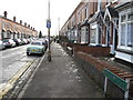
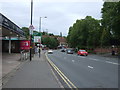
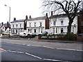
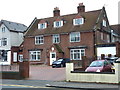
Photos of B17 8EA


Area Information
B17 8EA is a small residential postcode area in England, home to 1513 people spread across a compact cluster of properties. The area’s character is defined by its mature demographic, with a median age of 47 and a majority of residents aged between 30 and 64. This suggests a community rooted in stability, with many households likely established for decades. The area is predominantly composed of houses, reflecting a traditional residential layout. While its size is modest, B17 8EA offers practical access to nearby amenities, including multiple retail outlets, railway stations, and metro stops. This connectivity ensures residents can navigate daily life with ease, whether commuting or accessing local services. The area’s proximity to transport networks and its relatively low flood risk make it an appealing choice for those seeking a balance between residential tranquillity and urban accessibility. However, the high crime risk score of 2/100 underscores the need for vigilance, a factor potential buyers should weigh carefully.
- Area Type
- Postcode
- Area Size
- Not available
- Population
- Not available
- Population Density
- Not available
The property market in B17 8EA is characterised by a 53% home ownership rate, with houses making up the majority of accommodation types. This suggests a market skewed towards owner-occupied homes rather than rental properties, which may indicate a more settled population with long-term residency. The limited scale of the area means property choices are constrained, but the focus on houses rather than flats or apartments could appeal to buyers seeking space and privacy. However, the high crime risk score of 2/100 may influence property values and desirability, potentially deterring some buyers. For those considering the area, the compact nature of B17 8EA means proximity to nearby amenities and transport links is a key selling point, though buyers should assess the safety implications carefully.
House Prices in B17 8EA
No properties found in this postcode.
Energy Efficiency in B17 8EA
Living in B17 8EA offers access to a range of practical amenities within reach. Retail options include Aldi Warley, Iceland Bearwood, and Tesco Edgbaston, providing everyday shopping convenience. The area’s proximity to railway stations such as Smethwick Galton Bridge High Level and metro stops like Winson Green Outer Circle ensures efficient travel for work or leisure. While specific parks or leisure facilities are not detailed in the data, the presence of multiple transport links and retail outlets suggests a lifestyle focused on accessibility and connectivity. The compact nature of the area means residents can navigate daily needs without long commutes, though the lack of named green spaces or cultural venues may be a consideration for those prioritising recreational amenities.
Amenities
Schools
| Rank | School | Type | Entry gender | Ages |
|---|
Explore more schools in this area
Go to Schools tabDemographics
The population of B17 8EA is 1513, with a median age of 47, indicating a mature community where most residents are in their middle years. The most common age range is 30–64, suggesting a mix of families and long-term residents. Home ownership in the area stands at 53%, slightly below the national average, with houses being the predominant type of accommodation. This implies a stable housing market, though with limited rental availability. The predominant ethnic group is White, reflecting the area’s demographic composition. While no specific data on deprivation is provided, the age profile and home ownership rate suggest a community with established economic foundations. However, the high crime risk score of 2/100 may impact perceptions of safety and quality of life, particularly for families or retirees prioritising security.
Household Size
Accommodation Type
Tenure
Ethnic Group
Religion
Household Composition
Age
Household Deprivation
NS-SEC
Explore more demographic insights in this area
Go to Demographics tabPlanning
Planning Constraints
- Flood RiskPremium
- Ramsar Wetland SitesPremium
- Area of Outstanding Natural BeautyPremium
- Protected Nature ReservePremium
- Protected WoodlandPremium