Area Overview for B16 9LZ
Photos of B16 9LZ
Area Information
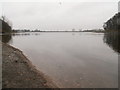
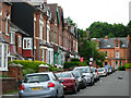
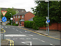
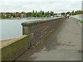
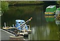
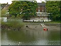
B16 9LZ is a small residential postcode nestled in the North Edgbaston ward of Birmingham, a historically affluent area with roots in 19th-century landownership by the Gough-Calthorpe and Gillott families. Its population of 2,077 reflects a tight-knit community, though the area’s size means it is more of a cluster than a sprawling suburb. Situated south-west of Birmingham’s city centre, it benefits from proximity to the metropolis’s cultural and commercial hubs while retaining a quieter, residential character. The ward’s heritage as a place where “the trees begin” persists in its green spaces, such as Edgbaston Pool, a Site of Special Scientific Interest, and Deer’s Leap Wood. Despite its compact nature, B16 9LZ offers access to key amenities, including primary schools, rail links, and retail hubs. Its blend of historical preservation and modern connectivity makes it a niche choice for those seeking a balance between urban convenience and semi-rural charm.
- Area Type
- Postcode
- Area Size
- Not available
- Population
- 2077
- Population Density
- 5483 people/km²
B16 9LZ is a rental-dominated area, with only 29% of homes owned by residents. The accommodation type is almost exclusively flats, which is typical for smaller postcodes in urban settings. This suggests a limited supply of owner-occupied properties, potentially making the area more attractive to investors or those seeking long-term rental options. The small size of the postcode means buyers should consider nearby wards for more housing diversity. Flats in B16 9LZ may cater to professionals or families looking for convenience over space, given the area’s compact nature. However, the low home ownership rate also indicates that property values may be influenced more by rental demand than owner occupation.
House Prices in B16 9LZ
No properties found in this postcode.
Energy Efficiency in B16 9LZ
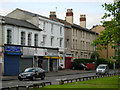
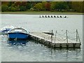
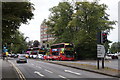
B16 9LZ’s residents have access to a range of amenities within practical reach. Retail options include Tesco Hagley, Spar Ample, and Tesco Edgbaston, providing everyday shopping needs. The area’s proximity to Edgbaston Village and Centenary Square offers dining, leisure, and cultural opportunities. Green spaces like Edgbaston Pool and Deer’s Leap Wood add recreational value, while the nearby BBC Pebble Mill Studios site (now the Birmingham Dental Hospital) hints at a legacy of creative industry. The mix of retail, transport, and natural spaces creates a convenient yet characterful lifestyle, blending urban accessibility with pockets of tranquillity.
Amenities
Schools
The nearest school to B16 9LZ is St Paul’s School for Girls, a primary school with an outstanding Ofsted rating. This provides a high-quality educational option for families with younger children, though no secondary schools are listed in the data. The presence of a top-rated primary school is a significant draw for families, but those requiring secondary education may need to look beyond the immediate area. The school’s rating suggests strong academic performance and facilities, which could enhance the area’s appeal. However, the absence of secondary schools means prospective buyers should assess commuting options for older children.
| Rank | School | Type | Entry gender | Ages |
|---|
Explore more schools in this area
Go to Schools tabDemographics
The population of B16 9LZ skews older, with a median age of 47 and the majority of residents aged 30–64. This suggests a community of established professionals and families, though the 29% home ownership rate indicates that most households are renters. The accommodation type is predominantly flats, reflecting a mix of purpose-built housing and conversions. The predominant ethnic group is White, though no data is provided on other demographics. The age profile and ownership figures imply a stable, mature population with limited turnover, which can influence local services and amenities. The absence of specific deprivation data means the area’s quality of life remains unquantified, but the low flood risk and proximity to transport links suggest resilience.
Household Size
Accommodation Type
Tenure
Ethnic Group
Religion
Household Composition
Age
Household Deprivation
NS-SEC
Explore more demographic insights in this area
Go to Demographics tabPlanning
Planning Constraints
- Flood RiskPremium
- Ramsar Wetland SitesPremium
- Area of Outstanding Natural BeautyPremium
- Protected Nature ReservePremium
- Protected WoodlandPremium