Area Overview for B16 9JG
Photos of B16 9JG


Area Information
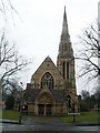
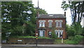
Living in B16 9JG means inhabiting a small, tightly knit residential cluster in North Edgbaston, a ward in Birmingham’s west. With a population of 1,553, this area blends historic charm with modern convenience. Situated just south-west of Birmingham city centre, it retains echoes of its 19th-century past, when the Gough-Calthorpe and Gillott families ensured it remained a leafy, affluent retreat. Today, it is a practical choice for those seeking proximity to the city’s core while benefiting from a quieter, residential vibe. The ward’s nickname, “where the trees begin,” hints at its green spaces and low-rise character. Despite its compact size, B16 9JG offers access to Birmingham’s cultural and economic hubs, with nearby landmarks like Edgbaston Hall and the former BBC Pebble Mill Studios now redeveloped. This area suits professionals and families looking for a balance between urban accessibility and a sense of community, though its small scale means amenities are concentrated within walking distance.
- Area Type
- Postcode
- Area Size
- Not available
- Population
- 1553
- Population Density
- 6879 people/km²
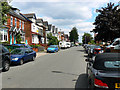
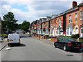
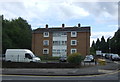
The property market in B16 9JG is characterised by a high proportion of rental properties, with only 27% of homes owned by residents. This suggests the area is more of a rental market than an owner-occupied one, which could influence property values and investment opportunities. The accommodation type is predominantly flats, a feature common in smaller, densely populated residential clusters. For buyers, this means the housing stock is limited in scale and likely to be smaller units, which may appeal to those seeking affordability or convenience in a compact area. The low home ownership rate also implies competition for available properties, particularly for those prioritising ownership. Given the area’s proximity to Birmingham’s city centre, it may attract professionals or students looking for short-term housing, though the small size of the postcode means the immediate surroundings are key to assessing broader property options.
House Prices in B16 9JG
Showing 12 properties
Energy Efficiency in B16 9JG
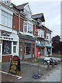
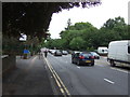
Life in B16 9JG is shaped by its proximity to retail, transport hubs, and the city’s urban core. The area’s retail offerings include Tesco Hagley, Tesco Edgbaston, and Spar Ample, providing everyday shopping needs within walking distance. Metro areas like Edgbaston Village and Soho Benson Road add to the local character, while rail stations such as Five Ways and University connect residents to broader Birmingham. Though the area is small, its placement near Birmingham’s central districts means residents can access cultural venues, dining options, and leisure activities in the city. The compact nature of B16 9JG means daily life is efficient, with amenities concentrated nearby. However, the absence of named parks or green spaces in the immediate vicinity suggests that residents may need to travel slightly further for outdoor recreation, despite the area’s historic greenery mentioned in its background.
Amenities
Schools
| Rank | School | Type | Entry gender | Ages |
|---|
Explore more schools in this area
Go to Schools tabDemographics
The community in B16 9JG is predominantly middle-aged, with a median age of 47 and the most common age range being adults aged 30–64. This suggests a stable population of professionals and families, though the 27% home ownership rate indicates that most residents are renters. The area’s accommodation is largely flats, reflecting its compact nature and historical development as a residential cluster. The predominant ethnic group is White, though no specific data on diversity beyond this is provided. The low home ownership rate may impact long-term investment potential, but it also means the area is likely to cater to a transient demographic. With no data on deprivation levels, it is unclear how this affects quality of life, but the age profile suggests a community focused on established careers and family life.
Household Size
Accommodation Type
Tenure
Ethnic Group
Religion
Household Composition
Age
Household Deprivation
NS-SEC
Explore more demographic insights in this area
Go to Demographics tabPlanning
Planning Constraints
- Flood RiskPremium
- Ramsar Wetland SitesPremium
- Area of Outstanding Natural BeautyPremium
- Protected Nature ReservePremium
- Protected WoodlandPremium