Area Overview for B16 8TE
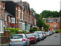
Photos of B16 8TE


Area Information
B16 8TE is a small residential postcode in west Birmingham, England, encompassing a compact cluster of homes within the Ladywood Ward. With a population of 2,198, it reflects the character of an inner-city district shaped by historical regeneration. The area lies near Birmingham’s core, close to landmarks like the Council House and Town Hall, and is bordered by areas such as Hockley and Lee Bank. Daily life here is defined by proximity to urban amenities, though the community faces challenges typical of inner-city living. The ward’s history includes 19th- and 20th-century slum clearance, leaving a legacy of both redevelopment and persistent social issues. Despite this, B16 8TE remains a hub for families and professionals, with its compact size offering a mix of residential calm and city-centre convenience. The area’s demographic profile—skewed toward adults aged 30–64 and a strong Asian presence—adds to its distinct identity. For buyers, it is a niche postcode where proximity to Birmingham’s heart beats against the realities of urban living.
- Area Type
- Postcode
- Area Size
- Not available
- Population
- 2198
- Population Density
- 2728 people/km²
B16 8TE is primarily a house-dominated area, with 56% of properties owner-occupied. This suggests a community of long-term residents rather than a transient rental market. The presence of houses, rather than flats, is notable in an inner-city postcode, indicating a preference for traditional housing stock. However, the small size of the area—covering only a residential cluster—means the housing stock is limited, potentially leading to competition among buyers. The high proportion of owner-occupied homes may reflect a desire for stability, but it also implies fewer rental options for those seeking flexibility. For buyers, this small postcode offers a niche opportunity, but its proximity to Birmingham’s centre comes with the trade-off of urban challenges, including the area’s documented crime concerns. The lack of high-rise or modern developments further reinforces its character as a compact, historically rooted residential zone.
House Prices in B16 8TE
No properties found in this postcode.
Energy Efficiency in B16 8TE
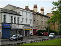
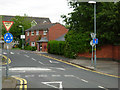
Life in B16 8TE revolves around its proximity to Birmingham’s core, offering access to a range of amenities within practical reach. The area’s five metro stops, including Edgbaston Village and Centenary Square, provide easy access to the city’s cultural and commercial districts. Retail options such as Morrisons Edgbaston and Spar cater to daily needs, while the five nearby rail stations—Five Ways, Jewellery Quarter, and Birmingham Snow Hill—connect residents to wider transport networks. The presence of landmarks like the Town Hall and Council House adds a civic dimension to the area’s character. However, the lack of parks or leisure facilities within the postcode suggests that residents must venture slightly further for green spaces or recreational activities. The compact nature of B16 8TE means its amenities are concentrated, offering convenience but also reinforcing the urban density that defines inner-city living.
Amenities
Schools
B16 8TE is served by three primary schools: The Oratory Roman Catholic Primary School and Ladywood School. Both are primary institutions, though no Ofsted ratings are provided in the data. The duplication of The Oratory Roman Catholic Primary School’s name may indicate a single school with multiple campuses or a data entry error, but this remains unclear. For families, the availability of two primary schools offers some choice, though the absence of secondary schools or specialist provisions is notable. The lack of detailed performance data means parents must rely on local reputation or direct visits to assess quality. Given the area’s demographic profile—skewed toward adults aged 30–64—many residents may have children in secondary education elsewhere, but for younger families, the existing primary options are the primary resource.
| Rank | School | Type | Entry gender | Ages |
|---|
Explore more schools in this area
Go to Schools tabDemographics
The population of B16 8TE is 2,198, with a median age of 47, reflecting a mature community where adults aged 30–64 form the largest age group. Home ownership sits at 56%, indicating a mix of owner-occupied properties and rental units. The area is predominantly composed of houses, not flats, which is unusual for inner-city zones. The dominant ethnic group is Asian, a factor that shapes the cultural and social fabric of the ward. This demographic profile suggests a community with established roots, though the area’s history of deprivation—linked to 20th-century slum clearance—may influence local services and infrastructure. The lack of younger families, combined with the high proportion of adults, implies a focus on stability over rapid growth. For residents, this means a quieter, more settled environment, though the absence of data on deprivation levels beyond historical context leaves some questions about contemporary quality of life.
Household Size
Accommodation Type
Tenure
Ethnic Group
Religion
Household Composition
Age
Household Deprivation
NS-SEC
Explore more demographic insights in this area
Go to Demographics tabPlanning
Planning Constraints
- Flood RiskPremium
- Ramsar Wetland SitesPremium
- Area of Outstanding Natural BeautyPremium
- Protected Nature ReservePremium
- Protected WoodlandPremium