Area Overview for B16 0JW
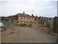
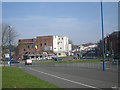
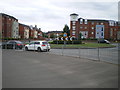
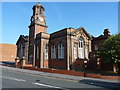
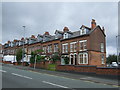
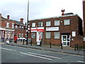
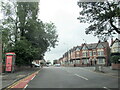
Photos of B16 0JW

Area Information
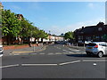
Living in B16 0JW means being part of a small, tightly knit residential cluster in the heart of Birmingham’s West Midlands. With a population of 1,942, this area is compact yet historically significant, situated south-west of Birmingham city centre. Once part of Warwickshire, it is now a ward within Birmingham City Council, known for its 19th-century heritage and tree-lined streets. The area’s charm lies in its blend of quiet residential life and proximity to the city’s energy. Edgbaston Hall, a Grade II listed building, stands as a local landmark, now serving as the clubhouse for Edgbaston Golf Club. The nickname “where the trees begin” reflects its green character, though modern amenities like retail parks and transport links ensure convenience. Residents benefit from easy access to Birmingham’s cultural and economic hubs, with a mix of historic sites and contemporary facilities. The area’s appeal is balanced by its practicality: it is not a high-density zone, making it ideal for those seeking a quieter, more traditional lifestyle without sacrificing connectivity.
- Area Type
- Postcode
- Area Size
- Not available
- Population
- 1942
- Population Density
- 8925 people/km²
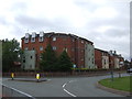
The property market in B16 0JW is characterised by a 44% home ownership rate, meaning nearly half of residents rent their homes. This suggests a rental market that may be more dynamic than owner-occupied, though the area’s housing stock is primarily composed of houses rather than flats. With a small population and limited land area, the number of available properties is constrained, making the market potentially competitive for buyers. The predominance of houses indicates larger, more spacious properties, which could appeal to families or those seeking traditional living. However, the low home ownership rate may also reflect affordability challenges, as purchasing property in this area might require significant investment. For buyers, this small postcode’s proximity to Birmingham’s amenities—such as schools, transport, and retail—offers practical advantages, though the limited size of the area means that property values and availability could be influenced heavily by local demand.
House Prices in B16 0JW
No properties found in this postcode.
Energy Efficiency in B16 0JW
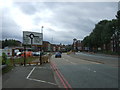
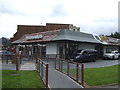
Life in B16 0JW is supported by a range of nearby amenities, including retail outlets like Lidl Winson, Farmfoods Smethwick, and M&S Midland, which cater to daily shopping needs. The area’s proximity to metro lines such as Winson Green Outer Circle and Soho Benson Road, along with rail stations like Five Ways Railway Station, ensures easy access to Birmingham’s cultural and commercial centres. While the data does not mention parks or leisure facilities directly, the historical context of Edgbaston—home to Edgbaston Pool and Deer’s Leap Wood—suggests green spaces may be nearby. The presence of multiple retail and transport options contributes to a convenient, active lifestyle, though the small size of the area means that residents may need to travel slightly further for specialist services. The mix of practical amenities and historical character offers a balanced environment for both daily living and leisure.
Amenities
Schools
The nearest school to B16 0JW is City Road Primary School, which serves the area with primary education. The school has an Ofsted rating of “good,” indicating a satisfactory standard of teaching and facilities. While the data lists the same school name three times, it is likely a single institution with multiple entries. The absence of secondary schools in the data means that families may need to look further afield for secondary education, though the proximity to Birmingham’s broader infrastructure could provide options. The presence of a “good” rated primary school is a key asset for families, offering a stable educational foundation. However, the lack of detailed information on school capacity, pupil numbers, or specific programmes means that further research into the school’s performance and alignment with a child’s needs would be necessary.
| Rank | School | Type | Entry gender | Ages |
|---|
Explore more schools in this area
Go to Schools tabDemographics
B16 0JW has a median age of 47, with the majority of residents aged 30–64. This suggests a mature, stable community with a strong presence of working-age adults. Home ownership here is 44%, lower than the national average, indicating a mix of owner-occupied and rental properties. The area is predominantly composed of houses rather than flats, reflecting a more traditional housing stock. The predominant ethnic group is Asian_total, which shapes the cultural fabric of the neighbourhood. This demographic profile means the area is likely to have established families and professionals, with a focus on long-term stability. The relatively low population of 1,942 implies a close-knit community where social ties may be strong. However, the lower home ownership rate could signal a higher proportion of renters, potentially affecting property values and investment opportunities. The data does not provide specific deprivation metrics, but the presence of retail and transport amenities suggests a reasonable standard of living.
Household Size
Accommodation Type
Tenure
Ethnic Group
Religion
Household Composition
Age
Household Deprivation
NS-SEC
Explore more demographic insights in this area
Go to Demographics tabPlanning
Planning Constraints
- Flood RiskPremium
- Ramsar Wetland SitesPremium
- Area of Outstanding Natural BeautyPremium
- Protected Nature ReservePremium
- Protected WoodlandPremium