Area Overview for B14 7LX
Photos of B14 7LX


Area Information
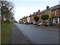
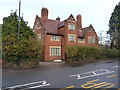
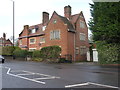
Living in B14 7LX means inhabiting a small, defined postcode area in Birmingham’s Brandwood & King’s Heath Ward. With a population of 1,588, it is a compact residential cluster characterised by historic development. The area’s roots trace back to 18th-century heathland, later shaped by road improvements and 19th-century housing expansions. Situated south of Birmingham’s city centre, it blends suburban tranquillity with proximity to urban amenities. Residents benefit from a stable community, with 83% of homes owner-occupied and a median age of 47, suggesting a mix of established families and middle-aged professionals. The area’s low flood risk and absence of protected natural sites make it practical for long-term living. While not a high-density zone, its small size means proximity to nearby towns and transport links. For those seeking a balance between local charm and city access, B14 7LX offers a distinct, manageable footprint of residential life.
- Area Type
- Postcode
- Area Size
- Not available
- Population
- 1588
- Population Density
- 4347 people/km²
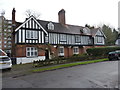
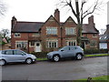
The property market in B14 7LX is largely owner-occupied, with 83% of homes owned by residents rather than rented. This suggests a community of long-term residents invested in their homes. The accommodation type is predominantly houses, which contrasts with areas dominated by flats or apartments. This housing stock likely appeals to families or individuals seeking space and privacy. Given the small size of the postcode area, buyers may need to look beyond immediate surroundings for additional options. The high home ownership rate implies strong local demand, potentially supporting property values. However, the limited size of the area means competition for available homes could be intense, requiring buyers to consider nearby suburbs or transport links for broader choices.
House Prices in B14 7LX
No properties found in this postcode.
Energy Efficiency in B14 7LX
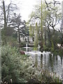
The lifestyle in B14 7LX is shaped by its proximity to retail, transport, and green spaces. Nearby shops include Co-op Kings, Sainsburys Kings, and Lidl Moseley, offering everyday essentials. Rail stations such as Bournville and Selly Oak connect residents to Birmingham’s business districts and cultural hubs. The area’s historical roots are evident in sites like the Hare and Hounds pub, a 19th-century landmark. While specific parks are not detailed, the absence of protected natural areas suggests open spaces may be limited. Nonetheless, the blend of retail, transport, and heritage sites creates a convenient, community-oriented environment. Residents can enjoy local amenities while maintaining access to the city’s vibrancy.
Amenities
Schools
Near B14 7LX are two primary schools: Colmore Junior School, rated ‘good’ by Ofsted, and Colmore Infant and Nursery School, rated ‘outstanding’. These institutions cater to early years education and primary schooling, providing a seamless transition for families. The presence of both infant and junior schools reduces the need for long commutes for younger children, a key consideration for parents. The ‘outstanding’ rating at the infant school highlights high-quality early education, while the ‘good’ rating at the junior school suggests reliable standards. Together, they form a cohesive educational network for families in the area, though secondary schooling options are not detailed here. This mix of primary schools supports a community focused on family-friendly infrastructure.
| Rank | School | Type | Entry gender | Ages |
|---|
Explore more schools in this area
Go to Schools tabDemographics
B14 7LX has a median age of 47, with the majority of residents falling within the 30–64 age range. This suggests a community dominated by adults in their prime working years, likely including families and professionals. Home ownership is high at 83%, indicating a stable, long-term resident base. The area is primarily composed of houses rather than flats, reflecting a preference for single-family dwellings. The predominant ethnic group is White, though no specific data on diversity beyond this is provided. The absence of detailed deprivation metrics means quality of life is inferred from factors like safety and amenities. With no significant planning constraints or environmental risks, the area appears to cater to a middle-aged, settled population seeking reliable, low-maintenance living.
Household Size
Accommodation Type
Tenure
Ethnic Group
Religion
Household Composition
Age
Household Deprivation
NS-SEC
Explore more demographic insights in this area
Go to Demographics tabPlanning
Planning Constraints
- Flood RiskPremium
- Ramsar Wetland SitesPremium
- Area of Outstanding Natural BeautyPremium
- Protected Nature ReservePremium
- Protected WoodlandPremium