Area Overview for B14 6ED
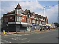
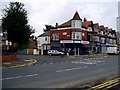
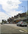
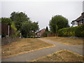
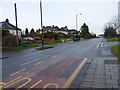
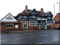
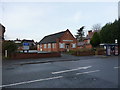
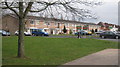
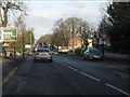
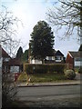
Photos of B14 6ED

Area Information
Living in B14 6ED means being part of a small residential cluster in England’s West Midlands, where suburban charm meets practicality. With a population of 1,738, this area is compact yet connected, nestled in the Brandwood & King’s Heath Ward of Birmingham. Historically shaped by 18th-century road improvements and 19th-century housing expansions, the area avoids the congestion of city centres while retaining a distinct identity. Residents here benefit from a mix of heritage and modernity, with landmarks like the Hare and Hounds pub and Brandwood House standing alongside contemporary amenities. The postcode’s proximity to Bournville Railway Station and Edgbaston Village ensures easy access to Birmingham’s cultural and commercial hubs. Daily life is balanced, with a focus on family-oriented living, reflected in the area’s median age of 47 and strong home ownership rates. For those seeking a community that values stability and convenience, B14 6ED offers a blend of quiet residential streets and accessible urban connectivity.
- Area Type
- Postcode
- Area Size
- Not available
- Population
- 1738
- Population Density
- 3436 people/km²
The property market in B14 6ED is defined by a high rate of home ownership (67%) and a predominance of houses over flats. This suggests a community where long-term residency and family living are prioritised, with properties likely offering more space and privacy than typical urban housing. The absence of flats indicates a lack of high-density development, which may appeal to buyers seeking traditional, single-family homes. Given the area’s small size, the housing stock is likely limited, making it a niche market for those specifically targeting suburban Birmingham. For buyers, this means a focus on individual properties rather than investment in larger developments. The stability of home ownership also implies a lower turnover of properties, which can be advantageous for those seeking secure, long-term assets. However, the limited scale of the area means that the immediate surroundings, rather than the postcode itself, may hold more extensive housing options.
House Prices in B14 6ED
No properties found in this postcode.
Energy Efficiency in B14 6ED
The lifestyle in B14 6ED is shaped by its proximity to a range of amenities, including retail outlets like Tesco Kings, Spar Millpool, and Lidl Warstock. These shops provide everyday convenience, from groceries to household essentials, reducing the need for long trips to larger centres. The area’s rail stations—Bournville, Yardley Wood, and Kings Norton—offer direct links to Birmingham’s cultural and commercial districts, while nearby metro stops such as Edgbaston Village and Centenary Square connect residents to the city’s broader network. This blend of local shops and transport hubs supports a practical, accessible lifestyle. The area’s historical sites, such as the Hare and Hounds pub and Brandwood House, add character to daily life, offering spaces for socialising and reflection. Overall, B14 6ED balances suburban tranquillity with urban connectivity, ensuring residents can enjoy both local charm and broader opportunities.
Amenities
Schools
The nearest school to B14 6ED is Woodthorpe Junior and Infant School, a primary institution with an Ofsted rating of ‘good’. This rating indicates that the school meets national standards in teaching quality, pupil outcomes, and leadership. As a primary school, it serves the needs of local families with young children, offering a foundation for early education. The presence of a single primary school in the area suggests a focus on community-based schooling, with families likely relying on this institution for their children’s education. While no secondary schools are listed, the proximity to Birmingham’s broader network of schools may provide additional options for older students. The ‘good’ rating reinforces the area’s appeal to families prioritising quality education, though further research would be needed to assess the full range of educational opportunities available.
| Rank | School | Type | Entry gender | Ages |
|---|
Explore more schools in this area
Go to Schools tabDemographics
The community in B14 6ED is predominantly composed of adults aged 30–64, with a median age of 47. This suggests a mature, established population, likely with strong ties to local institutions and long-term residency. Home ownership is high at 67%, indicating a stable housing market and a focus on property as an investment. The area is characterised by houses rather than flats, which aligns with its suburban profile and appeal to families. The predominant ethnic group is White, reflecting broader demographic trends in the region. While specific data on deprivation is absent, the high home ownership and median age suggest a community with relatively stable economic conditions. This profile supports a lifestyle centred on long-term residency, with residents likely prioritising family-oriented amenities and local services. The area’s compact size means its demographics are tightly woven into the broader dynamics of Birmingham’s West Midlands suburbs.
Household Size
Accommodation Type
Tenure
Ethnic Group
Religion
Household Composition
Age
Household Deprivation
NS-SEC
Explore more demographic insights in this area
Go to Demographics tabPlanning
Planning Constraints
- Flood RiskPremium
- Ramsar Wetland SitesPremium
- Area of Outstanding Natural BeautyPremium
- Protected Nature ReservePremium
- Protected WoodlandPremium