Area Overview for B14 5PF
Photos of B14 5PF
Area Information
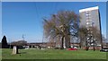
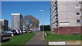
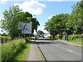
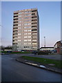
Living in B14 5PF means residing in a small, tightly knit residential cluster within Druids Heath, a postwar housing estate in Birmingham’s south-west quadrant. With a population of 1,405, this area is defined by its 1960s tower blocks and flat-based housing stock, built on former farmland to address postwar housing needs. The estate’s character is shaped by its proximity to Bells Lane and Druids Lane, with redevelopment plans announced in 2025 aiming to replace over 1,000 council homes with mixed-tenure housing and green spaces. Daily life here is marked by a mix of urban practicality and community ties, though challenges such as deprivation and aging infrastructure persist. The area’s history includes the closure of Baverstock School in 2025, a once-notable institution for academic and sports achievements. Residents navigate a landscape of modest amenities, with nearby rail and metro connections offering links to Birmingham’s broader networks. While the area ranks among Birmingham’s most deprived, its proximity to retail hubs and transport routes provides functional access to urban services.
- Area Type
- Postcode
- Area Size
- Not available
- Population
- 1405
- Population Density
- 6429 people/km²
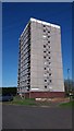
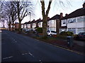
The property market in B14 5PF is dominated by rental flats, with home ownership at just 14%. The housing stock consists almost entirely of 1960s tower blocks, including structures like Moor House, Pleck House, and Drews House, many of which are scheduled for demolition as part of Birmingham’s redevelopment plans. This makes the area a rental-focused zone, with limited opportunities for owner-occupation. The flat-based model suits those seeking affordable housing but offers little in terms of long-term investment potential. Buyers considering the area should note that the immediate surroundings are similarly characterised by postwar housing, with no significant private housing developments. The planned redevelopment could alter the landscape, but for now, the market remains geared toward tenants rather than homeowners.
House Prices in B14 5PF
No properties found in this postcode.
Energy Efficiency in B14 5PF
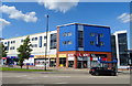
The lifestyle in B14 5PF is defined by practicality and proximity to essential amenities. Retail options include Iceland Maypole, Aldi Warstock, and Sainsburys Maypole, offering everyday shopping needs within reach. Rail stations like Yardley Wood and Shirley provide access to Birmingham’s broader transport network, while metro stops such as Edgbaston Village and Grand Central New Street link to central business districts. Though the area lacks high-end leisure facilities, its location near the Maypole and Bells Lane offers a baseline of convenience. Residents benefit from a mix of retail, transport, and urban connectivity, though the absence of parks or recreational spaces highlights a gap in the local landscape. The area’s character is one of functional accessibility, prioritising daily necessities over luxury amenities.
Amenities
Schools
Residents of B14 5PF have access to three schools within practical reach. St Jude’s Catholic Primary School, a primary school with an Ofsted rating of ‘good’, provides a faith-based education for younger children. Nearby is Baverstock Foundation School and Specialist Sports College, a primary school with a focus on sports, though its Ofsted rating is not specified. The Baverstock Academy, an academy school, serves older students, though its exact educational focus is not detailed in the data. The mix of primary and academy schools offers families a range of options, though the absence of secondary school ratings and the closure of Baverstock School in 2025 may raise concerns about continuity. Parents should consider the proximity of these institutions and their specific curricular strengths when evaluating the area’s suitability for their children.
| Rank | School | Type | Entry gender | Ages |
|---|---|---|---|---|
| 1 | St Jude's Catholic Primary School | primary | N/A | N/A |
| 2 | Baverstock Foundation School and Specialist Sports College | primary | N/A | N/A |
| 3 | The Baverstock Academy | academy | N/A | N/A |
Explore more schools in this area
Go to Schools tabDemographics
The population of B14 5PF is predominantly adults aged 30–64, with a median age of 47. Home ownership here is exceptionally low at 14%, reflecting a community largely reliant on rental housing. The accommodation type is almost exclusively flats, a legacy of the postwar estate’s design. The predominant ethnic group is White, though specific data on diversity beyond this is not provided. Deprivation levels are stark: 31.6% of children live in low-income households, and the ward ranks 25th out of 69 Birmingham wards for deprivation. This translates to challenges such as higher claimant unemployment, limited access to higher qualifications (31st highest share of working-age residents with no qualifications), and a 58.9% employment rate, slightly above the city average. These factors influence the area’s quality of life, with residents facing barriers to economic mobility and investment in local infrastructure.
Household Size
Accommodation Type
Tenure
Ethnic Group
Religion
Household Composition
Age
Household Deprivation
NS-SEC
Explore more demographic insights in this area
Go to Demographics tabPlanning
Planning Constraints
- Flood RiskPremium
- Ramsar Wetland SitesPremium
- Area of Outstanding Natural BeautyPremium
- Protected Nature ReservePremium
- Protected WoodlandPremium
- Crime RiskPremium