Area Overview for B13 9HE
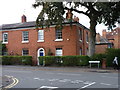
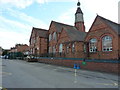
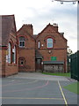
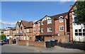
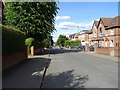
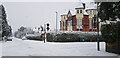
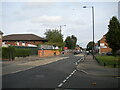
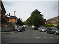
Photos of B13 9HE
Area Information
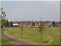
B13 9HE lies within Moseley, a historic suburban ward in south Birmingham, England. This small postcode area covers a compact residential cluster with a population of 1188, reflecting its modest scale. Moseley itself has roots as a 19th-century middle-class suburb, evolving from rural village to urban neighbourhood through phases of development. The area is defined by its proximity to landmarks like Moseley Park and Cannon Hill Park, which offer green spaces for residents. Living here means navigating a mix of older housing stock and modern infrastructure, with easy access to Birmingham’s transport networks. The community is tightly knit, with a median age of 47 and a population skewed toward adults aged 30–64. Daily life balances suburban tranquillity with the convenience of nearby retail, rail, and metro links, making it a practical choice for those seeking a blend of residential comfort and urban connectivity.
- Area Type
- Postcode
- Area Size
- Not available
- Population
- 1188
- Population Density
- 5665 people/km²
The property market in B13 9HE is characterised by a high proportion of flats, with 41% of homes owner-occupied. This suggests a rental market dominates, as the remaining 59% are likely rented or occupied by non-owners. The prevalence of flats indicates a focus on high-density housing, a legacy of Moseley’s 19th-century suburbanisation. For buyers, this means limited availability of larger properties, with most options being apartments or terraced units. The small area’s immediate surroundings may offer similar housing stock, but the compact postcode limits diversity in property types. The 41% home ownership rate also implies a transient population, with renters potentially outnumbering long-term residents. Buyers should consider the area’s practicality for those prioritising affordability and proximity to transport over expansive living spaces.
House Prices in B13 9HE
No properties found in this postcode.
Energy Efficiency in B13 9HE
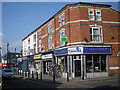
The lifestyle in B13 9HE is shaped by its proximity to retail, transport, and green spaces. Nearby shops include M&S Moseley, Co-op Moseley, and Lidl Sparkbrook, offering a range of goods from groceries to clothing. The area’s rail and metro links provide easy access to Birmingham’s central districts, while parks like Moseley Park and Cannon Hill Park—created from donated land in 1873—offer recreational space. The historical character of the area, including Spring Hill College and the Moseley Tunnel, adds cultural depth. Residents can enjoy a balance of suburban calm and urban accessibility, with leisure options ranging from local parks to historic sites. The compact size of the postcode means amenities are within walking or short-vehicle distance, supporting a convenient, low-stress lifestyle.
Amenities
Schools
The nearest school to B13 9HE is St Martin de Porres Catholic Primary School, which serves the area with a good Ofsted rating. This primary school is the only educational institution explicitly mentioned in the data, meaning families with children under 11 have access to a rated institution. However, the absence of secondary schools or further education facilities suggests that older students may need to travel to nearby areas for secondary education. The presence of a primary school with a good rating is a positive for families prioritising early education, though the lack of comprehensive school data means the full range of educational options remains unclear. Parents should investigate nearby secondary schools in Moseley or Birmingham for a complete picture of schooling opportunities.
| Rank | School | Type | Entry gender | Ages |
|---|---|---|---|---|
| 1 | St Martin de Porres Catholic Primary School | primary | N/A | N/A |
Explore more schools in this area
Go to Schools tabDemographics
The population of B13 9HE is predominantly adults aged 30–64, with a median age of 47. Home ownership here stands at 41%, indicating a mix of owner-occupied and rental properties. The accommodation type is primarily flats, reflecting the area’s historical development as high-density housing. The predominant ethnic group is White, though no specific diversity statistics are provided. This demographic profile suggests a mature, settled community with a focus on stability. The absence of detailed deprivation data means the area’s quality of life is inferred from its infrastructure and amenities. With a population of 1188, the neighbourhood is small enough to foster familiarity yet large enough to support essential services. The age range implies a population less likely to require childcare facilities, though the presence of a primary school nearby suggests families are present.
Household Size
Accommodation Type
Tenure
Ethnic Group
Religion
Household Composition
Age
Household Deprivation
NS-SEC
Explore more demographic insights in this area
Go to Demographics tabPlanning
Planning Constraints
- Flood RiskPremium
- Ramsar Wetland SitesPremium
- Area of Outstanding Natural BeautyPremium
- Protected Nature ReservePremium
- Protected WoodlandPremium
- Crime RiskPremium