Area Overview for B13 8YR
Photos of B13 8YR
Area Information
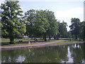
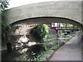
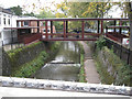
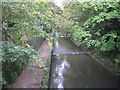
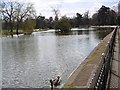
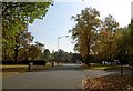
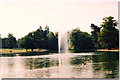
Living in B13 8YR means residing in a small, defined residential cluster within the Moseley area of Birmingham. With a population of 1,659, this postcode reflects a tight-knit community rooted in suburban history. Moseley, once an independent village, became part of Birmingham in 1911 and retains echoes of its 19th-century transformation into a middle-class suburb. The area is characterised by high-density housing, with a focus on family homes. Residents benefit from proximity to Cannon Hill Park, a public space gifted in 1873, and Moseley Park and Pool, a local landmark. The area’s transport legacy includes the Birmingham and Gloucester Railway, opened in 1840, and modern rail links to Birmingham New Street. Daily life here balances suburban tranquillity with access to city amenities, making it appealing for those seeking a blend of history and convenience.
- Area Type
- Postcode
- Area Size
- Not available
- Population
- 1659
- Population Density
- 2286 people/km²
The property market in B13 8YR is dominated by owner-occupied homes, with 77% of properties owned by residents. The accommodation type is primarily houses, which is unusual for urban areas and suggests a suburban, family-oriented character. This high home ownership rate indicates a stable market with limited rental activity, making it attractive for buyers seeking long-term investment. The small area’s housing stock is likely limited, but its proximity to Birmingham’s transport networks and green spaces may enhance its appeal. For buyers, the focus on houses implies a need to consider larger properties, though the area’s compact size means the immediate surroundings offer similar options.
House Prices in B13 8YR
No properties found in this postcode.
Energy Efficiency in B13 8YR
The lifestyle in B13 8YR is enriched by nearby amenities, including shops such as Aldi Edgbaston, Asda Edgbaston, and Co-op Moseley, which cater to everyday needs. Parks like Cannon Hill Park and Moseley Park and Pool provide green spaces for leisure and recreation. The area’s historical character, including Spring Hill College and the Moseley Tunnel, adds cultural depth. Transport links to rail and metro stations ensure easy access to Birmingham’s city centre and beyond, blending suburban comfort with urban connectivity. This mix of practicality and heritage creates a balanced daily life.
Amenities
Schools
The nearest school to B13 8YR is Red Boots School, a special school with an Ofsted rating of outstanding. This institution caters to students requiring specialist education, offering a high standard of care and academic support. The presence of a special school nearby may indicate a community with diverse family needs, though no mainstream schools are listed in the data. Families seeking mainstream education may need to look beyond the immediate area, but the quality of the existing school reflects a commitment to educational provision.
| Rank | School | Type | Entry gender | Ages |
|---|---|---|---|---|
| 1 | Red Boots School (National Institute of Conductive Education) | special | N/A | N/A |
Explore more schools in this area
Go to Schools tabDemographics
The community in B13 8YR has a median age of 47, with the majority of residents aged 30–64. This suggests a mature, stable population, likely with established careers and families. Home ownership is high at 77%, indicating a predominance of long-term residents. The accommodation type is primarily houses, reflecting a suburban layout rather than high-rise or shared housing. The predominant ethnic group is Asian_total, highlighting the area’s cultural diversity. While no specific deprivation data is provided, the high home ownership and age profile suggest a community with economic stability and a focus on long-term living.
Household Size
Accommodation Type
Tenure
Ethnic Group
Religion
Household Composition
Age
Household Deprivation
NS-SEC
Explore more demographic insights in this area
Go to Demographics tabPlanning
Planning Constraints
- Flood RiskPremium
- Ramsar Wetland SitesPremium
- Area of Outstanding Natural BeautyPremium
- Protected Nature ReservePremium
- Protected WoodlandPremium
- Crime RiskPremium