Area Overview for B13 0LF
Photos of B13 0LF


Area Information
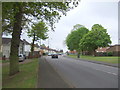
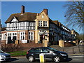
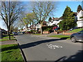
Billesley sits four miles south-east of Birmingham city centre, forming a distinct residential cluster within the B13 postcode area. This specific location, identified by the B13 0LF postcode, encompasses about 1,692 residents and reflects a mature, established neighbourhood. The suburb originated in 1921 when the Billesley Estates developed former Ivy House Farm and Billesley Farm. By 1926, council estates accommodated 15-20 new families each week, cementing its status as one of Birmingham's earliest public housing projects. Today, the ward blends areas of Billesley, Moseley, Hall Green, Yardley Wood, and Kings Heath. You will find the zone bordered by Billesley Common, Chinn Brook Meadows, The Dingles, and Swanshurst Park. Living in B13 0LF offers access to these green spaces alongside the broader suburban fabric. The area retains strong historical ties, with Billesley Manor dating back to 705 AD and appearing in the Domesday Book. Its expansion into a modern suburb began a century ago, creating a built environment that values stability and long-term residence.
- Area Type
- Postcode
- Area Size
- Not available
- Population
- 1692
- Population Density
- 7896 people/km²
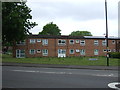
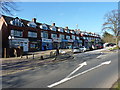
You are looking at a market dominated by owner-occupiers in this specific postcode. With 60% home ownership, the housing stock in B13 0LF is primarily residential homes where people have settled permanently. Houses form the main accommodation type, distinguishing this area from high-density urban blocks or private rental enclaves. This pattern often reflects the history of the suburb, which expanded from 1921 using former farmland for council housing before evolving into a mixed-stock residential area. Buyers considering homes in this location should expect a stock designed for larger plots and private gardens rather than flats. The high ownership rate suggests a stable property market with fewer transient households. This contrasts with areas heavily driven by short-term rentals or student accommodation. If you are purchasing a home here, you are joining a majority of residents who have invested in their living space. The prevalence of houses supports a market where families and older buyers remain for the long term, creating continuity in the local aesthetic and community structure.
House Prices in B13 0LF
No properties found in this postcode.
Energy Efficiency in B13 0LF
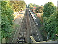
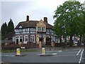
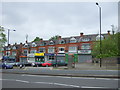
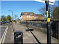
Your daily routine in B13 0LF is supported by a practical network of retail and rail amenities within easy reach. Five retail outlets serve the immediate vicinity, including Heron Yardley, Tesco Robin, and Lidl Warstock. These shops provide straightforward access to groceries and essentials without requiring a car. For commuters, rail links connect you to Yardley Wood Railway Station, Hall Green Railway Station, and Shirley Railway Station. This rail access allows you to reach Grand Central New Street, Edgbaston Village, and Corporation Street via the metro network. The proximity of these stations integrates the suburb into the wider Birmingham transport web, reducing travel stress. Beyond commerce, the area is defined by local parks such as Billesley Common, which hosts the Friends of Billesley Commons group. You also have access to Chinn Brook Meadows, The Dingles, and Swanshurst Park. These green spaces offer walking routes and places for relaxation close to home. Life here balances convenience with outdoor opportunity, giving you easy access to both shopping and nature within a short commute.
Amenities
Schools
| Rank | School | Type | Entry gender | Ages |
|---|
Explore more schools in this area
Go to Schools tabDemographics
The community in B13 0LF is defined by a mature population, with a median age of 47 years. Adults aged between 30 and 64 years represent the most common age range, indicating a neighbourhood where households typically consist of settled families or established professionals. Home ownership stands at 60%, suggesting that a majority of residents have purchased their properties rather than renting. This high level of possession aligns with the predominance of houses as the main accommodation type. The demographic profile reflects stability, with fewer young children or empty-nester ratios skewing the average. Previous census data suggested a ward population near 21,172, though the specific B13 0LF cluster holds a smaller resident count of 1,692. The predominant ethnic group is White, consistent with the broader suburban character of the West Midlands. You will find a community where households are likely deep-rooted, given the ownership rates and the age distribution. This demographic structure means the area caters to those seeking quiet, family-oriented environments rather than rapid urban development trends.
Household Size
Accommodation Type
Tenure
Ethnic Group
Religion
Household Composition
Age
Household Deprivation
NS-SEC
Explore more demographic insights in this area
Go to Demographics tabPlanning
Planning Constraints
- Flood RiskPremium
- Ramsar Wetland SitesPremium
- Area of Outstanding Natural BeautyPremium
- Protected Nature ReservePremium
- Protected WoodlandPremium