Area Overview for B12 9SB
Photos of B12 9SB
Area Information
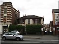
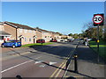
Living in B12 9SB means being part of a compact, historically rich postcode area nestled in Birmingham’s south. With a population of 1,561, it is a small but distinct cluster of homes, shaped by its origins as part of the former Kings Norton Parish in Worcestershire. The area’s character reflects its evolution from 19th-century farmland to a modern residential hub, with a legacy of urban renewal and cultural diversity. Today, B12 9SB is home to a community defined by its proximity to amenities like schools, rail links, and parks, while retaining echoes of its past as a site of industrial expansion and social change. The area’s compact size means residents are within easy reach of Birmingham’s city centre, yet it retains a quieter, more localised feel. With a median age of 47 and a population skewed towards adults aged 30–64, the area is neither dominated by students nor retirees, suggesting a stable, family-oriented demographic. For those seeking a balance between urban convenience and historical character, B12 9SB offers a unique blend of practicality and heritage.
- Area Type
- Postcode
- Area Size
- Not available
- Population
- 1561
- Population Density
- 7377 people/km²
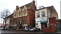
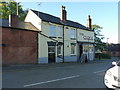
The property market in B12 9SB is characterised by a low home ownership rate of 31%, indicating that the area is more rental-focused than owner-occupied. This suggests a reliance on private landlords or housing associations, which may affect the availability of long-term leases or the potential for property value growth. The predominant accommodation type is houses, rather than apartments or flats, which is uncommon in many urban centres. This could appeal to families seeking more space, but it also means the housing stock is limited in scale, particularly given the area’s small size. For buyers, this dynamic implies that opportunities for purchase may be constrained, with competition likely among those seeking to own a home in a compact, well-served postcode. The presence of houses also means that the area may lack the high-density housing typical of other parts of Birmingham, which could be a consideration for those prioritising affordability or proximity to transport.
House Prices in B12 9SB
No properties found in this postcode.
Energy Efficiency in B12 9SB
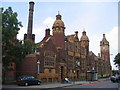
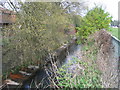
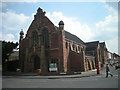
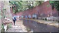
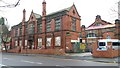
The lifestyle in B12 9SB is shaped by its proximity to amenities that cater to everyday needs. Residents can access retail options like Lidl Sparkbrook, Co-op Moseley, and Aldi Edgbaston, ensuring fresh groceries and household essentials are within reach. The area’s parks, including Calthorpe Park (opened 1857) and Balsall Heath Park (1894), offer green spaces for recreation, walking, and relaxation, reflecting the Victorian-era emphasis on public parks. Historical sites such as the Balsall Heath Library (1895) and Balsall Heath Baths (1907) add cultural and social value. The presence of a Shia Mosque on Clifton Road and the legacy of the College of Art on Moseley Road highlight the area’s diverse community and artistic heritage. These amenities contribute to a balanced lifestyle, combining practicality with historical and cultural richness.
Amenities
Schools
Residents of B12 9SB have access to a range of schools, including state-funded and independent institutions. Tindal Junior and Infant School and Ark Tindal Primary Academy are both primary schools, with the latter holding a ‘good’ Ofsted rating, which is a strong indicator of quality for families seeking reliable early education. Moseley Women Academy and Sz School are independent institutions, offering alternative educational pathways. The Birmingham Rathbone School of LE is a special needs school, providing tailored support for students with specific requirements. This mix of school types ensures that families have options, whether they prefer state education, independent schooling, or specialist provision. The presence of a ‘good’-rated primary school is a notable advantage, as it suggests a solid foundation for younger children’s learning. However, the lack of secondary schools in the immediate area may require families to consider commuting or broader catchment areas for older students.
| Rank | School | Type | Entry gender | Ages |
|---|---|---|---|---|
| 1 | Tindal Junior and Infant School | primary | N/A | N/A |
| 2 | Moseley Women Academy | independent | N/A | N/A |
| 3 | Birmingham Rathbone School of LE | special | N/A | N/A |
| 4 | Sz School | independent | N/A | N/A |
| 5 | Ark Tindal Primary Academy | primary | N/A | N/A |
Explore more schools in this area
Go to Schools tabDemographics
The population of B12 9SB has a median age of 47, with the majority of residents falling within the 30–64 age range. This suggests a community of working-age adults, likely including families and professionals. Home ownership is relatively low at 31%, indicating that a significant portion of the area is occupied by renters, which may influence the local housing market and social dynamics. The predominant accommodation type is houses, rather than flats, reflecting a more traditional residential layout. The area’s demographic profile is further shaped by its status as a hub for the Asian community, which constitutes the largest ethnic group. This diversity is likely to contribute to a rich cultural environment, though it also means the area may have specific community needs and social infrastructure. The relatively low home ownership rate and older age profile suggest a community that values stability and proximity to services over property investment.
Household Size
Accommodation Type
Tenure
Ethnic Group
Religion
Household Composition
Age
Household Deprivation
NS-SEC
Explore more demographic insights in this area
Go to Demographics tabPlanning
Planning Constraints
- Flood RiskPremium
- Ramsar Wetland SitesPremium
- Area of Outstanding Natural BeautyPremium
- Protected Nature ReservePremium
- Protected WoodlandPremium
- Crime RiskPremium