Area Overview for B12 9QZ
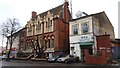
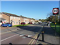
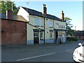
Photos of B12 9QZ

Area Information
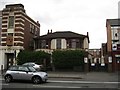
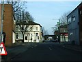
B12 9QZ is a small residential postcode area within the Balsall Heath West ward of Birmingham, a historically significant part of the city. With a population of 1,561, it sits in a neighbourhood that has evolved from 19th-century farmland into a modern urban cluster. The area’s character reflects its layered history: once a site of industrial expansion and post-war decline, it now features a mix of older housing stock and recent renewal efforts. Balsall Heath itself, of which this postcode is a part, was annexed into Birmingham in 1891 and has since become home to diverse communities, including one of the city’s largest Muslim populations. Living here means navigating a compact, densely populated environment with proximity to key amenities. The area’s compact nature means residents are within walking distance of shops, transport hubs, and parks, though the small size also means limited housing stock. For buyers, B12 9QZ offers a snapshot of Birmingham’s complex urban fabric—historic charm intertwined with the practicalities of modern living.
- Area Type
- Postcode
- Area Size
- Not available
- Population
- 1561
- Population Density
- 7377 people/km²
The property market in B12 9QZ is characterised by a low home ownership rate of 31%, suggesting that the area is largely a rental market rather than one dominated by owner-occupiers. The accommodation type is predominantly houses, which is unusual for a small postcode area, as it may indicate a mix of older, larger properties and newer builds. This combination could mean that the housing stock is varied but limited in quantity, creating competition among buyers and renters. For those seeking to purchase, the small size of the area means that available properties are likely to be in high demand, with limited scope for expansion. The presence of houses rather than flats or apartments may appeal to families or those preferring more space, though the low home ownership rate suggests that many residents may not have long-term plans to stay. Buyers should consider the area’s compact nature and the potential for limited future development when evaluating properties here.
House Prices in B12 9QZ
No properties found in this postcode.
Energy Efficiency in B12 9QZ
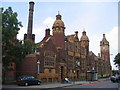
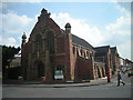
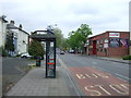
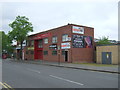
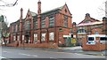
The lifestyle in B12 9QZ is shaped by its proximity to essential amenities. Retail options include Lidl Sparkbrook, Co-op Moseley, and M&S Moseley, providing access to groceries, clothing, and everyday essentials. The area’s transport links to rail and metro stations mean that residents can easily reach larger shopping centres or Birmingham’s city centre. Parks and green spaces are also within reach, with Calthorpe Park (opened 1857) and Balsall Heath Park (1894) offering recreational opportunities. These parks, with their Victorian-era design, provide space for walking, sports, and relaxation. The presence of a Shia Mosque on Clifton Road and historical sites like the Balsall Heath Library and Baths reflect the area’s cultural and social heritage. While the immediate vicinity is compact, the mix of retail, transport, and green spaces supports a functional daily life, though residents may need to travel further for more specialised services.
Amenities
Schools
Residents of B12 9QZ have access to a range of school types, including state and independent institutions. Tindal Junior and Infant School is a primary school, while Ark Tindal Primary Academy, also a primary school, holds a “good” Ofsted rating, indicating a reliable standard of education. Moseley Women Academy and Sz School are independent institutions, offering alternative educational pathways for families seeking private schooling. Birmingham Rathbone School of LE is a special school, providing support for students with specific needs. The mix of school types ensures that families can choose between state-funded options, which are generally more affordable, and independent schools, which may offer smaller class sizes or specialist curricula. However, the absence of secondary schools in the immediate vicinity means that students may need to travel further for secondary education, which could be a consideration for parents planning their children’s schooling.
| Rank | School | Type | Entry gender | Ages |
|---|
Explore more schools in this area
Go to Schools tabDemographics
The population of B12 9QZ is 1,561, with a median age of 47, indicating a community skewed toward middle-aged adults. The most common age range is 30–64 years, suggesting a mix of working-age residents and those nearing retirement. Home ownership here is relatively low at 31%, pointing to a rental-dominated market, which may affect property value stability. The area is predominantly composed of houses, though the exact distribution of household types is not specified. The predominant ethnic group is identified as “asian_total,” reflecting the broader demographic trends in Balsall Heath, where a significant Muslim community has been established since the 1940s. This diversity shapes the area’s cultural landscape, though it also means services and amenities must cater to a range of needs. The lower home ownership rate may indicate economic pressures or a preference for renting, which could influence the local property market’s dynamics.
Household Size
Accommodation Type
Tenure
Ethnic Group
Religion
Household Composition
Age
Household Deprivation
NS-SEC
Explore more demographic insights in this area
Go to Demographics tabPlanning
Planning Constraints
- Flood RiskPremium
- Ramsar Wetland SitesPremium
- Area of Outstanding Natural BeautyPremium
- Protected Nature ReservePremium
- Protected WoodlandPremium