Area Overview for B12 9EL
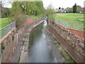
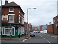
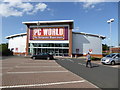
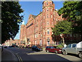
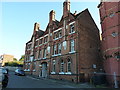
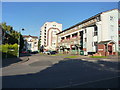
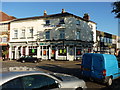
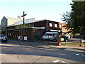
Photos of B12 9EL
Area Information
Living in B12 9EL, part of the Balsall Heath West electoral ward in Birmingham, means inhabiting a small, tightly knit residential cluster with a population of 1,708. Situated in the south of the city, this area has evolved from 19th-century farmland into a modern urban neighbourhood. Its history is marked by annexation into Birmingham in 1891 and subsequent urban renewal efforts that reshaped its character. Today, B12 9EL reflects a blend of post-war housing and contemporary development, with a strong presence of the city’s Asian community. Daily life here is shaped by proximity to Moseley Road, a historic thoroughfare, and access to nearby amenities. The area’s compact size means residents are within walking distance of shops, transport hubs, and green spaces, offering a balance of urban convenience and community cohesion. While it retains echoes of its past as a red-light district, B12 9EL now prioritises family living, with schools, parks, and cultural landmarks like the Shia Mosque on Clifton Road contributing to its identity.
- Area Type
- Postcode
- Area Size
- Not available
- Population
- 1708
- Population Density
- 7649 people/km²
The property market in B12 9EL is characterised by a 45% home ownership rate, suggesting it is not a strong owner-occupied area. The predominant accommodation type is houses, which is unusual in Birmingham’s typically terraced housing stock. This mix may appeal to buyers seeking larger properties, but the small area’s limited housing stock means competition is likely. The low home ownership rate indicates a reliance on rental properties, which could affect long-term value appreciation. For buyers, the focus on houses may mean fewer options compared to nearby areas with more flats. However, the presence of nearby amenities and transport links could offset the area’s smaller scale, making it attractive for those prioritising location over property type.
House Prices in B12 9EL
No properties found in this postcode.
Energy Efficiency in B12 9EL
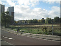
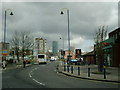
Life in B12 9EL is shaped by its proximity to retail, transport, and green spaces. Nearby shops include Co-op Birmingham, Lidl Sparkbrook, and Morrisons Daily Bristol, offering daily essentials. The area’s transport network, with railway stations and metro stops, ensures easy access to Birmingham’s core. Parks such as Calthorpe Park (opened 1857) and Balsall Heath Park (1894) provide recreational space, while historic landmarks like the Shia Mosque on Clifton Road add cultural depth. The mix of Victorian-era amenities and modern retail creates a convenient, varied lifestyle. Residents can enjoy both urban vibrancy and pockets of greenery, making daily life practical yet engaging.
Amenities
Schools
The nearest school to B12 9EL is Iqra Girls High School, an independent institution. No Ofsted rating is provided, but its independent status suggests it may cater to specific educational preferences. The absence of state schools in the immediate vicinity means families relying on public education may need to look beyond the postcode. However, the area’s proximity to Moseley Road and historical links to the College of Art and Balsall Heath Library could offer alternative learning resources. For those prioritising independent schooling, Iqra Girls High School is a notable option, though its suitability depends on individual needs and budget.
| Rank | School | Type | Entry gender | Ages |
|---|
Explore more schools in this area
Go to Schools tabDemographics
B12 9EL’s population skews young, with a median age of 22, though the most common age range is adults aged 30–64. This suggests a mix of young professionals and families. Home ownership here is relatively low at 45%, indicating a rental-dominated market. The area is primarily composed of houses rather than flats, which is uncommon in Birmingham’s high-density zones. The predominant ethnic group is Asian, reflecting broader trends in the city’s demographic makeup. While no specific deprivation data is provided, the presence of a large Muslim community and the area’s history of economic decline in the 1970s and 1980s may influence local quality of life. The 45% home ownership rate means renters form the majority, which could impact housing stability and investment potential.
Household Size
Accommodation Type
Tenure
Ethnic Group
Religion
Household Composition
Age
Household Deprivation
NS-SEC
Explore more demographic insights in this area
Go to Demographics tabPlanning
Planning Constraints
- Flood RiskPremium
- Ramsar Wetland SitesPremium
- Area of Outstanding Natural BeautyPremium
- Protected Nature ReservePremium
- Protected WoodlandPremium