Area Overview for B12 0PB
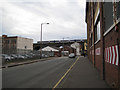
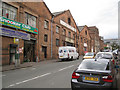
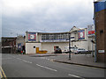
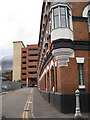
Photos of B12 0PB
Area Information
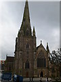
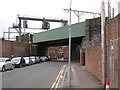
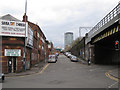
B12 0PB is a compact postcode area in Birmingham’s heart, encompassing parts of Bordesley, Highgate, and Digbeth. With a population of 1,582 spread over 6,672 square metres, it is one of the city’s most densely populated zones. This area, created in 2017, sits within the Birmingham Ladywood parliamentary constituency and includes historic sites like Bordesley Hall, though much of its character stems from 19th-century industrial development. Daily life here is defined by proximity to the city’s core, with easy access to rail, metro, and retail hubs. The area’s demographics reflect a young, working-age population, with 20% owning homes and the rest likely renting flats. While the historical roots are deep, the modern reality is one of urban living, where convenience of location balances against the challenges of high population density. For buyers, this postcode offers a small, defined cluster of properties, ideal for those prioritising connectivity over space.
- Area Type
- Postcode
- Area Size
- 6672 m²
- Population
- 1582
- Population Density
- 3153 people/km²
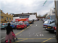
B12 0PB’s property market is heavily rental-focused, with only 20% of homes owned by residents. The area’s accommodation is almost exclusively flats, reflecting its urban, high-density layout. This makes it a niche market for buyers, as the limited number of owner-occupied properties may appeal to those seeking a compact, centrally located home. The small area size means property choices are restricted to a handful of flats, often in multi-unit buildings. For buyers, this postcode is not ideal for those seeking larger homes or land, but it suits those prioritising proximity to Birmingham’s core. The rental market here is likely competitive, with demand driven by the area’s transport links and proximity to amenities. Potential buyers should consider the high population density and limited space when evaluating long-term suitability.
House Prices in B12 0PB
Showing 1 properties
| Address | Type | Beds | Baths | Last Sale Price | Last Sale Date | |
|---|---|---|---|---|---|---|
| 96 Bradford Street, Birmingham, B12 0PB | Detached | - | - | - | - |
Energy Efficiency in B12 0PB
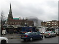
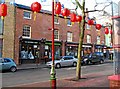
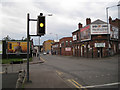
Living in B12 0PB offers a mix of urban convenience and proximity to Birmingham’s core. Nearby amenities include Spar, Tesco, and M&S for retail, while metro stations like Corporation Street and Grand Central New Street provide easy access to the city’s business and cultural hubs. The area’s historical industrial roots are less visible in daily life, but its modern character is defined by accessibility. Residents can walk or cycle to nearby rail stations, reducing reliance on cars. However, the data does not mention parks or leisure facilities, suggesting a focus on commercial and transport infrastructure over green spaces. The compact layout means amenities are close, but the high population density may impact privacy or outdoor space. For those who prioritise connectivity and urban convenience, this area offers a functional, if compact, lifestyle.
Amenities
Schools
The nearest school to B12 0PB is Chandos Primary School, which serves the area with primary education. The school has an Ofsted rating of “satisfactory,” indicating it meets basic standards but may lack outstanding features. As the only named school in the data, it is the primary option for local families, though no secondary schools are listed. The absence of higher education institutions or additional schools may require families to seek options further afield. The “satisfactory” rating suggests that while the school functions adequately, it may not offer exceptional resources or academic performance. For parents prioritising a strong local education system, this limitation could be a concern, requiring careful consideration of nearby alternatives.
| Rank | School | Type | Entry gender | Ages |
|---|
Explore more schools in this area
Go to Schools tabDemographics
The community in B12 0PB is predominantly adults aged 30–64, with a median age of 22. This suggests a mix of young professionals and families, though the 20% home ownership rate indicates that most residents are renters. The area’s accommodation is almost entirely flats, reflecting its urban, high-density character. The predominant ethnic group is White, though specific diversity metrics are not provided. The high population density of 237,097 people per square kilometre means shared spaces and communal living are common. For quality of life, this density can strain local services but also fosters a tightly knit community. The age profile suggests a workforce-oriented population, with potential demand for nearby employment opportunities. However, the lack of data on deprivation levels means it is unclear how economic pressures might affect daily life.
Household Size
Accommodation Type
Tenure
Ethnic Group
Religion
Household Composition
Age
Household Deprivation
NS-SEC
Explore more demographic insights in this area
Go to Demographics tabPlanning
Planning Constraints
- Flood RiskPremium
- Ramsar Wetland SitesPremium
- Area of Outstanding Natural BeautyPremium
- Protected Nature ReservePremium
- Protected WoodlandPremium