Area Overview for B11 4RT
Photos of B11 4RT


Area Information
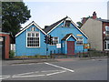
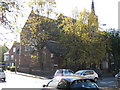
Living in B11 4RT, a small residential cluster in Birmingham’s Sparkhill area, offers a blend of urban convenience and historical character. With a population of 3,307, the area is part of a broader inner-city district shaped by 19th-century industrial development and 20th-century migration. Sparkhill’s name may derive from the Sparke family or the Spark Brook stream, which flows into the River Cole. Today, it is a hub of ethnic diversity, influenced by successive waves of Irish, Afro-Caribbean, South Asian, and more recent Somali and Romanian communities. The area’s compact size means residents are close to Birmingham’s cultural and economic centres, with easy access to nearby districts like Sparkbrook and Hall Green. Despite its urban setting, Sparkhill retains historic features such as St John’s Church and the former Birmingham Women’s Hospital. For buyers, this postcode represents a microcosm of Birmingham’s evolving identity, where terraced housing and community diversity coexist.
- Area Type
- Postcode
- Area Size
- Not available
- Population
- 3307
- Population Density
- 14903 people/km²
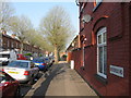
B11 4RT’s property market is defined by a 50% home ownership rate, indicating a mix of owner-occupied and rental properties. The area’s accommodation type is primarily houses, many of which are terraced or semi-detached, reflecting the 19th-century developments that characterise Sparkhill. These homes, often with back gardens, were originally built for working-class families and later expanded to include middle-class housing. The small postcode area means the housing stock is relatively uniform, with limited new-build developments. For buyers, this presents a straightforward market with clear property types, though the compact size may limit choice. The proximity to Birmingham’s transport networks and amenities makes it appealing for those seeking a balance between urban living and residential tranquillity.
House Prices in B11 4RT
No properties found in this postcode.
Energy Efficiency in B11 4RT
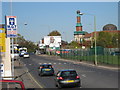
B11 4RT offers a convenient lifestyle with access to essential amenities. Retail options include Asda Sparkhill, Aldi Sparkbrook, and Spar City, providing everyday shopping needs. The area’s transport links connect residents to Birmingham’s broader network, with railway stations like Bordesley and metro stops such as Corporation Street within reach. Historic pubs like the Mermaid Inn and The Antelope add character, while the nearby Balti Triangle offers a vibrant dining scene. The mix of retail, transport, and cultural landmarks ensures a dynamic daily life, blending practicality with the area’s heritage.
Amenities
Schools
Residents of B11 4RT have access to a range of educational institutions. Arden Primary School, a state-funded primary school, holds a good Ofsted rating, ensuring quality education for younger children. Nearby, Al-Noor Girls Secondary School is an independent institution, offering an alternative for families seeking private schooling. The combination of state and independent options provides flexibility for parents, whether they prioritise public education or seek specialist provision. Both schools are within practical reach of the area, supporting families with children. The presence of a good-rated primary school enhances the area’s appeal, particularly for those seeking reliable local education.
| Rank | School | Type | Entry gender | Ages |
|---|
Explore more schools in this area
Go to Schools tabDemographics
The population of B11 4RT has a median age of 22, though the most common age range is adults aged 30–64, indicating a working-age population. Home ownership sits at 50%, suggesting a balance between owner-occupied properties and rental stock. The predominant accommodation type is houses, reflecting a mix of terraced and semi-detached homes built during the 19th and 20th centuries. The area’s ethnic composition is dominated by the South Asian community, with Asian_total as the largest group. This diversity is evident in local businesses and cultural landmarks, such as the Balti Triangle’s restaurants. The demographic profile supports a dynamic, family-oriented community, with schools and amenities catering to a range of needs. The absence of specific deprivation data means quality of life is inferred from the area’s strong connectivity, low crime rates, and access to services.
Household Size
Accommodation Type
Tenure
Ethnic Group
Religion
Household Composition
Age
Household Deprivation
NS-SEC
Explore more demographic insights in this area
Go to Demographics tabPlanning
Planning Constraints
- Flood RiskPremium
- Ramsar Wetland SitesPremium
- Area of Outstanding Natural BeautyPremium
- Protected Nature ReservePremium
- Protected WoodlandPremium