Area Overview for B11 4NW
Photos of B11 4NW

Area Information
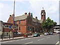
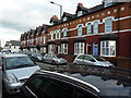
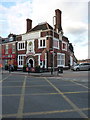
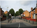
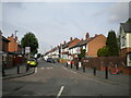
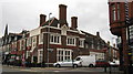
Living in B11 4NW offers a distinct connection to Sparkhill, an inner-city area of Birmingham situated between Springfield, Hall Green, and Sparkbrook. This specific postcode cluster contains a population of 1,877 residents, forming a tight-knit residential community within a larger historical settlement. The area sits at coordinates 52.456576, -1.866038, placing it firmly in the West Midlands English Region while retaining strong links to its Worcestershire origins. Historically, Sparkhill transformed from a rural agricultural site in the Middle Ages into a working-class housing estate during the Industrial Revolution. By the late 1860s, uniform terraced houses with back gardens lined the streets, while larger properties served the local wealthier families near Stoney Lane, Alfred Road, and Durham Road. Today, daily life in B11 4NW reflects a deep urban character where the past meets the present. The neighbourhood retains historic anchors such as St John's Church, designed by Martin and Chamberlain in 1888, and Sparkhill Library, which opened in 1923. You will find reminders of the local telegraph history and the area's split into the West Midlands. The community remains rooted in its heritage while adapting to modern needs. Residents enjoy proximity to the former site of the Birmingham Women's Hospital and walk through streets shaped by post-War rebuilding efforts after the BSA factory bombings. Living here means sharing a postcode that bridges these historical layers with contemporary urban living, offering a established residential cluster away from the city centre's immediate bustle.
- Area Type
- Postcode
- Area Size
- Not available
- Population
- 1877
- Population Density
- 9837 people/km²
The property market in B11 4NW is characterised by a predominance of houses, with no data indicating the presence of flats or apartments within this specific cluster. This housing stock aligns closely with the area's historical development as a working-class estate. In 1860s, uniform terraced houses with coal sheds and private spaces were constructed, and much of this style remains or has been renovated into modern family homes. The standing of the market is evident in the home ownership rate, which reaches 72%. This places B11 4NW well above the national average for home ownership, signalling a market where residents buy rather than rent. For prospective homebuyers, this means the available properties are likely owned by families who have lived here for generations. When looking at homes in B11 4NW, you are entering a market with low rental turnover. The housing is primarily single-family units, fitting the needs of adults aged 30 to 64. This structure supports a market where price stability is common, driven by a lack of speculative short-term tenancies. If you are searching for properties in Sparkhill, expect to find detached or semi-detached houses rather than high-density developments. The area does not cater to investors seeking short-term rental yields because the stock is almost entirely owner-occupied. This creates a secure investment environment where property values tend to remain steady as owners maintain their estates rather than relist frequently.
House Prices in B11 4NW
No properties found in this postcode.
Energy Efficiency in B11 4NW
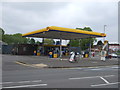
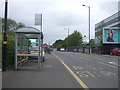
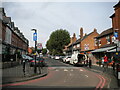
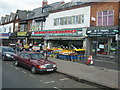
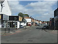
Living in B11 4NW provides convenient access to a wide range of retail, dining, and leisure options. In terms of shopping, you are close to Asda Sparkhill, Aldi Sparkbrook, and M&S Moseley. These supermarkets form the backbone of local retail, offering daily necessities within a short drive or walk. For cultural and leisure activities, the area boasts rich history, including St John's Church, which houses the Narthex Sparkhill charity. You may also explore the former Yardley District Council house, now Sparkhill Library, a notable example of early double-glazing in public buildings. Local amenities extend to historic public houses like the Mermaid Inn, The Bear, and The Antelope, many featuring art deco decoration by sculptor William Bloye. While some have converted to restaurants reflecting the area's culinary diversity, they remain landmarks of the streetscape. Public transportation is integrated into daily life, with five major rail stations including Grand Central New Street nearby. The diversity of the area is visible in its dining scene, which includes numerous eateries serving South Asian curry. This concentration of cuisine reflects the local population but also serves visitors. You will find that lifestyle in B11 4NW balances historic charm with modern convenience. The presence of both traditional pubs and contemporary chain stores offers variety for different tastes and ages.
Amenities
Schools
| Rank | School | Type | Entry gender | Ages |
|---|
Explore more schools in this area
Go to Schools tabDemographics
The community in B11 4NW is defined by stability and maturity. The median age stands at 47 years, reflecting a population dominated by adults between 30 and 64 years old. This age profile suggests a neighbourhood where long-term residents have settled deep roots. Home ownership is exceptionally high, with 72% of households owning their homes outright. This figure contrasts sharply with the wider market, indicating that B11 4NW is an area predominantly for existing owners rather than young renters. The accommodation type is exclusively houses, meaning those searching for flats or apartments will not find them within this specific postcode. Ethnically, the area features a predominantly Asian population, a fact that shapes the local culture and social fabric. This demographic mix has grown through successive waves of migration, including Irish, Afro-Caribbean, and South Asian communities, alongside more recent arrivals. The high proportion of owner-occupied homes suggests a community invested in stability over transient living. You will find fewer temporary tenants compared to other parts of Birmingham, creating an environment where neighbours often know one another well. The lack of significant rental stock means the local services and amenities cater largely to established families and individuals who have called this postcode home for years. This demographic consistency provides a predictable and quiet social atmosphere for those seeking established neighbourhoods.
Household Size
Accommodation Type
Tenure
Ethnic Group
Religion
Household Composition
Age
Household Deprivation
NS-SEC
Explore more demographic insights in this area
Go to Demographics tabPlanning
Planning Constraints
- Flood RiskPremium
- Ramsar Wetland SitesPremium
- Area of Outstanding Natural BeautyPremium
- Protected Nature ReservePremium
- Protected WoodlandPremium