Area Overview for B11 4NQ
Photos of B11 4NQ

Area Information
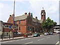
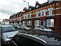
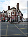
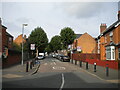
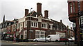
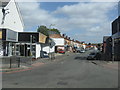
Living in B11 4NQ means residing in Sparkhill, an inner-city area of Birmingham situated between Springfield, Hall Green and Sparkbrook. This postcode covers a specific residential cluster with a recorded population of 2,004 people. Historically part of Worcestershire until its annexation by Birmingham in 1911, the area has transformed from a rural agricultural landscape to a dense urban environment. The location marks a significant transition zone within the city, blending historical industrial roots with modern residential life. The area's character is defined by its position near the "Balti Triangle," creating a distinct cultural atmosphere shaped by successive waves of migration throughout the 20th century. You are finding yourself in a community where history meets daily hustle, housed primarily within terraced properties that line the familiar streets of this postcode. Sparkhill occupies coordinates 52.456576, -1.866038 within the West Midlands English Region, offering a central location for commuters while maintaining a tight-knit feel. The area took its name either from the Sparke family who farmed there during the Middle Ages or from Spark Brook, a stream flowing toward the River Cole. Today, the residential cluster serves a diverse community that includes families, professionals, and retirees. The housing stock reflects its working-class origins, with many homes dating back to the 1850s when developers constructed uniform terraced houses with back gardens. As you explore the neighbourhood, you encounter landmarks like St John's Church, designed by architects Martin and Chamberlain. This area provides a grounded, practical setting where the past informs present-day life, offering a sense of stability to those seeking a home in this distinct Birmingham postcode.
- Area Type
- Postcode
- Area Size
- Not available
- Population
- 2004
- Population Density
- 8305 people/km²
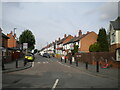
The property market in B11 4NQ is characterised by a stable housing stock where 63% of residents own their homes. This high rate of home ownership indicates that the area is not primarily a rental market, but rather a place where individuals seek to live and settle permanently. The dominant accommodation type is Houses, which shapes the physical environment and the nature of street life. You can expect to find traditional detached and semi-detached properties, alongside the uniform terraced houses that were built in the 1850s and 1970s. These homes often feature back gardens and coal sheds, reflecting the architectural style of the Industrial Revolution era when the area was developed. For buyers looking at B11 4NQ, the market dynamics suggest a locality focused on long-term residency rather than short-term tenancy. The presence of owner-occupied homesimplifies the ownership process, as there are fewer tenants to manage and lower property turnover rates. While the specific values of individual properties are not listed in the source data, the high ownership percentage implies a recurring market for inheritance, intra-family transfers, or trade-ups. The area's history of working-class housing construction means the properties are generally practical and functional. When assessing homes in B11 4NQ, you are likely to encounter maintained terraced families that have been improved by generations of owners. This stable market makes the area attractive for those seeking a conventional property purchase in a non-transient neighbourhood.
House Prices in B11 4NQ
No properties found in this postcode.
Energy Efficiency in B11 4NQ
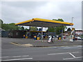
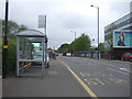
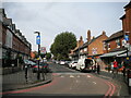
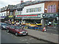
Daily life in B11 4NQ benefits from a wide array of amenities within practical reach. For shopping needs, residents have access to five major retail locations, notably Asda Sparkhill, Aldi Sparkbrook, and M&S Moseley. These supermarkets and department stores provide convenient access to groceries, clothing, and household essentials without the need for long travel. The proximity of these retailers supports a self-sufficient lifestyle, allowing you to manage household running costs time-efficiently. Transport options further enhance convenience, with five rail stations and five metro stations nearby. Small Heath Railway Station, Tyseley Railway Station, and Hall Green Railway Station offer rail links, while Grand Central New Street, Corporation Street, and Bull Street serve the metro network. This density means you can reach key city centres quickly. The area also links to Birmingham's historical and cultural sites, as Sparkhill is modern housing that developed alongside historic landmarks like St John's Church and Sparkhill Library. The nearby amenities create a functional environment where services are walking or short driving distance away. When considering lifestyle in B11 4NQ, you gain immediate access to the practical necessities of modern living.
Amenities
Schools
Families living in B11 4NQ have several educational options within practical reach, each serving distinct needs for primary and secondary education. The nearest primary schooling is provided by St John's CofE Primary School, which holds an Outstanding rating from Ofsted. You would be assured that this school meets the highest educational standards, offering a strong foundation for younger children. This specific rating indicates excellent teaching quality and outcomes, a crucial factor for parents planning their child's early education. For secondary education, the City of Birmingham School serves the needs of older students in the vicinity. While the specific Ofsted rating is not provided in the data, the presence of these established institutions ensures that the area is not educationally isolated. The mix of primary and secondary options means you do not need to travel far for different stages of your child's development. The proximity of St John's CofE Primary School to the B11 4NQ postcode means that daily commutes to school are short. When researching schools near B11 4NQ, the outstanding status of the local primary school stands out as a significant positive feature for families considering this residential cluster.
| Rank | School | Type | Entry gender | Ages |
|---|
Explore more schools in this area
Go to Schools tabDemographics
The community within B11 4NQ is defined by a mature resident base with a median age of 47 years. The majority of the population falls into the Adults (30-64 years) age range, indicating a neighbourhood settled by families and established households rather than young professionals or students. Home ownership stands at a solid 63% of the total population, signalling that the area is dominated by owner-occupiers who have put down roots in their local streets. This high level of tenure suggests a stable community where residents are likely to stay long-term, fostering local connections and continuity. Housing statistics for this postcode show a predominance of Houses, meaning you will find detached or semi-detached properties alongside the terraced stock mentioned in local history. The demographic profile highlights a significant ethnic diversity, with the Asian_total group forming the predominant ethnic community within the area. This cultural makeup has deeply influenced the local character, contributing to the area's reputation as a centre of Birmingham's "Balti Triangle." The combination of a high home ownership rate and a mature age profile creates a quiet, family-oriented environment. There are no transient populations to disrupt the neighbourhood routine, and the stable housing tenure supports a predictable lifestyle. When you consider living in B11 4NQ, you are joining a community where the residents are likely to know their neighbours and take a vested interest in the street's upkeep.
Household Size
Accommodation Type
Tenure
Ethnic Group
Religion
Household Composition
Age
Household Deprivation
NS-SEC
Explore more demographic insights in this area
Go to Demographics tabPlanning
Planning Constraints
- Flood RiskPremium
- Ramsar Wetland SitesPremium
- Area of Outstanding Natural BeautyPremium
- Protected Nature ReservePremium
- Protected WoodlandPremium