Area Overview for B11 4LA
Photos of B11 4LA
Area Information
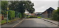
B11 4LA is a compact postcode area in Birmingham’s Sparkhill district, home to 2,148 residents. Nestled between Springfield, Hall Green, and Sparkbrook, this inner-city enclave reflects Birmingham’s layered history, from medieval farming roots to 19th-century industrial housing. Today, it is a vibrant, ethnically diverse community shaped by waves of migration, with South Asian influence evident in its famed Balti Triangle. The area’s small size means daily life is closely tied to its immediate surroundings, with a mix of historic architecture and modern amenities. Sparkhill’s proximity to rail and metro links, combined with its low flood risk and strong broadband connectivity, makes it appealing for those seeking urban convenience without sacrificing safety. While the population is relatively small, the area’s character is defined by its cultural richness, historic landmarks like St John’s Church, and a community that balances tradition with contemporary living. For buyers, B11 4LA offers a snapshot of Birmingham’s evolving identity—practical, connected, and rooted in resilience.
- Area Type
- Postcode
- Area Size
- Not available
- Population
- 2148
- Population Density
- 15223 people/km²
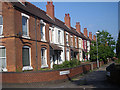
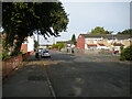
B11 4LA’s property market is dominated by owner-occupied homes, with 60% of residents owning their properties. The area’s housing stock consists primarily of houses, reflecting its historical development as a terraced housing estate built in the 1850s and 1860s. This mix of older and mid-century properties offers buyers a range of options, though the small postcode area means the stock is limited. The prevalence of houses, rather than flats, suggests a community prioritising space and privacy, which may appeal to families or those seeking more traditional living arrangements. However, the compact size of B11 4LA means buyers must consider nearby areas for larger or newer properties. The high home ownership rate indicates a stable market, but the lack of recent development data means potential buyers should assess the condition of individual properties carefully.
House Prices in B11 4LA
No properties found in this postcode.
Energy Efficiency in B11 4LA
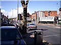
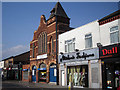
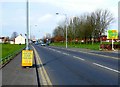
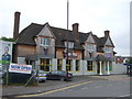
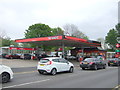
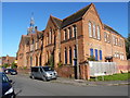
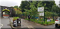
Living in B11 4LA offers a blend of practicality and cultural vibrancy. The area’s retail options include Aldi Sparkbrook, Asda Sparkhill, and Spar City, providing everyday essentials within walking distance. For commuters, rail stations like Small Heath and Tyseley, along with metro stops such as Corporation Street, ensure swift access to Birmingham’s transport network. Historically, the area was a hub for industry and community, with landmarks like St John’s Church and the converted Mermaid Inn reflecting its heritage. Today, the Balti Triangle’s restaurants highlight its South Asian influence, offering a distinct culinary scene. Sparkhill Library, one of the earliest public buildings with double-glazed windows, adds to the area’s charm. While green spaces are limited, the compact layout fosters a sense of closeness, with amenities clustered around key routes. This mix of history, culture, and convenience defines daily life in B11 4LA.
Amenities
Schools
| Rank | School | Type | Entry gender | Ages |
|---|
Explore more schools in this area
Go to Schools tabDemographics
The population of B11 4LA is predominantly adults aged 30–64, with a median age of 47, reflecting a mature, stable community. Home ownership rates stand at 60%, suggesting a mix of long-term residents and rental properties. The area is characterised by houses as the primary accommodation type, which aligns with its historical development as a working-class housing estate. Ethnically, the predominant group is South Asian, a legacy of 20th-century migration patterns that have shaped the area’s cultural fabric. This diversity is visible in local businesses and community hubs, such as the Balti Triangle’s restaurants. While deprivation data is not provided, the presence of amenities like Sparkhill Library and historic pubs indicates a community with access to both practical resources and cultural heritage. The age profile suggests a population focused on family life and stability, with services and infrastructure tailored to meet the needs of middle-aged residents.
Household Size
Accommodation Type
Tenure
Ethnic Group
Religion
Household Composition
Age
Household Deprivation
NS-SEC
Explore more demographic insights in this area
Go to Demographics tabPlanning
Planning Constraints
- Flood RiskPremium
- Ramsar Wetland SitesPremium
- Area of Outstanding Natural BeautyPremium
- Protected Nature ReservePremium
- Protected WoodlandPremium