Area Overview for B11 4BE
Photos of B11 4BE

Area Information
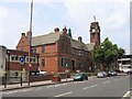
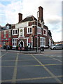
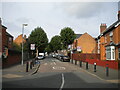
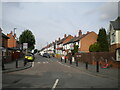
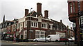
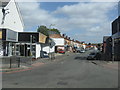
Living in B11 4BE means inhabiting a small, tightly knit residential cluster in Birmingham’s Sparkhill area. With a population of 1,619, this postcode is part of a historically rural district that transformed during the Industrial Revolution into a working-class housing hub. Today, it thrives as an urban area with a distinct cultural identity shaped by successive waves of migration. The area’s proximity to Springfield, Hall Green, and Sparkbrook places it at the heart of Birmingham’s “Balti Triangle,” where South Asian influence is evident in local businesses and community life. Despite its compact size, B11 4BE offers a blend of historic architecture, such as St John’s Church, and modern amenities. Its residents benefit from proximity to rail networks, retail outlets, and schools, making it a practical choice for families and commuters. The area’s character is defined by its ethnic diversity, with the Asian community forming a significant presence, alongside contributions from Irish, Afro-Caribbean, and more recent migrant groups.
- Area Type
- Postcode
- Area Size
- Not available
- Population
- 1619
- Population Density
- 8804 people/km²
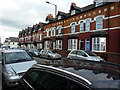
The property market in B11 4BE is characterised by a 60% home ownership rate, with houses forming the majority of accommodation types. This suggests a mix of owner-occupied properties and rental stock, though the exact proportion of rentals is not specified. The prevalence of houses, rather than flats or apartments, indicates a focus on family homes with garden space, which may appeal to buyers seeking stability and space. Given the area’s compact size, the housing stock is likely limited to smaller terraced or semi-detached properties, reflecting its historical development as a working-class housing area. For buyers, this means a market that prioritises practicality over luxury, with properties that cater to families and long-term residents. The lack of high-end or specialist housing types may limit options for those seeking specific property features.
House Prices in B11 4BE
No properties found in this postcode.
Energy Efficiency in B11 4BE
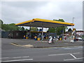
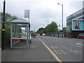
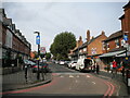
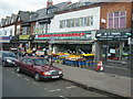
The lifestyle in B11 4BE is shaped by its proximity to retail, dining, and transport hubs. Within practical reach are five retail outlets, including Asda Sparkhill, Aldi Sparkbrook, and M&S Moseley, offering a range of shopping options. The area’s historic pubs, such as the Mermaid Inn and The Bear, reflect its cultural heritage, while the nearby Balti Triangle ensures a vibrant food scene with South Asian cuisine. Rail and metro stations provide easy access to Birmingham’s city centre and beyond, supporting both daily commutes and weekend outings. The presence of Sparkhill Library, a historic building with double-glazed windows, adds to the area’s character. For residents, this blend of practical amenities and cultural diversity creates a convenient, dynamic environment that balances urban convenience with community identity.
Amenities
Schools
Residents of B11 4BE have access to several primary schools, including Greet Primary School and English Martyrs’ Catholic Primary School, both of which hold a “good” Ofsted rating. Greet Primary School appears twice in the data, suggesting it may be a key educational institution in the area. The presence of two primary schools with positive ratings indicates a focus on early education, which is crucial for families. The mix of state and Catholic schools offers parents choice, though no secondary schools are listed. This suggests that students may need to travel to nearby areas for secondary education, which is common in smaller residential clusters. The quality of primary education, however, provides a strong foundation for local children, supporting the area’s appeal to families.
| Rank | School | Type | Entry gender | Ages |
|---|
Explore more schools in this area
Go to Schools tabDemographics
The demographic profile of B11 4BE reflects a community skewed toward adults aged 30–64, despite a median age of 22. This suggests a mix of younger residents, possibly students or young professionals, and a larger population of middle-aged households. Home ownership stands at 60%, with houses being the predominant accommodation type, indicating a stable, family-oriented housing stock. The area’s predominant ethnic group is the Asian community, which has shaped local culture and commerce. While no specific deprivation data is provided, the presence of diverse age groups and ownership rates suggests a balanced mix of long-term residents and newer arrivals. The median age being lower than the most common age range may hint at transient populations, such as students or young workers, coexisting with established families.
Household Size
Accommodation Type
Tenure
Ethnic Group
Religion
Household Composition
Age
Household Deprivation
NS-SEC
Explore more demographic insights in this area
Go to Demographics tabPlanning
Planning Constraints
- Flood RiskPremium
- Ramsar Wetland SitesPremium
- Area of Outstanding Natural BeautyPremium
- Protected Nature ReservePremium
- Protected WoodlandPremium