Area Overview for B11 3TZ
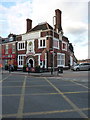
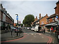
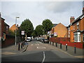
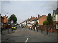
Photos of B11 3TZ

Area Information
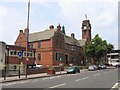
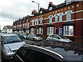
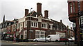
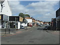
Living in B11 3TZ means residing within Sparkhill, a distinct residential cluster in inner-city Birmingham. This postcode serves approximately 1,915 residents, forming a tight-knit community situated between Springfield, Hall Green, and Sparkbrook. Historically part of Worcestershire before annexation by Birmingham in 1911, the area retains a working-class character shaped by its industrial past. Builder societies constructed uniform terraced houses with back gardens from the 1850s onwards, creating the rows of accommodation you see today. While specific acres for this small cluster are not detailed, its proximity to the Grand Canal and the River Cole defines its geography. The area functions as part of the larger Balti Triangle, known for its culinary diversity. Daily life revolves around the practicalities of urban living near Hall Green and Tyseley. You are steps away from key transport hubs and local parks like Wimborne Park. The neighbourhood has evolved significantly from its Domesday Book origins, transforming from rural farmland to a dense urban centre. Today, it offers a gritty, authentic slice of Birmingham life that has retained its historic charm through successive waves of migration and rebuilding.
- Area Type
- Postcode
- Area Size
- Not available
- Population
- 1915
- Population Density
- 12792 people/km²
The property landscape in B11 3TZ is defined by its stock of houses, which forms the backbone of the local housing market. With 47% home ownership, the area sits at a midpoint between a purely rental district and a homeowning community. This balance suggests a healthy mix of long-term residents and younger tenants. The housing stock largely consists of the uniform terraced houses built between the 1850s and early 20th century. Many of these properties retain original features like coal sheds and small gardens, though 1940s replacements also exist following wartime bombing near the BSA factory. Buyers considering this postcode should be prepared for a market driven by affordability and location rather than luxury finishes. The small residential nature of B11 3TZ means property values are tightly coupled with the broader Sparkhill and Hall Green clusters. Whether you seek to purchase or rent, the availability of traditional houses offers a specific character unmatched in newer developments outside the city.
House Prices in B11 3TZ
No properties found in this postcode.
Energy Efficiency in B11 3TZ
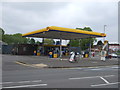
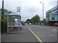
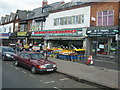
Your daily lifestyle in B11 3TZ is heavily influenced by the proximity of major retailers and transit hubs. Within practical reach are significant shopping parks, most notably Asda Sparkhill, Tesco Hall, and the Co-op in Sparkhill. These large hypermarkets provide essential groceries and household goods without the need for long journeys. Transport-wise, you are close to five railway stations, with Hall Green serving as a primary hub for regional travel. Further afield, New Street, Corporation Street, and Bull Street offer direct links into the city centre. The area's character is perhaps best defined by its gastronomy, stemming from its status as a centre of the Balti Triangle. Numerous South Asian eateries line the streets, offering accessible and affordable dining. You also have access to historic landmarks, such as St John's Church and the converted library. While parks like Wimborne Park are nearby, the immediate experience is one of urban convenience surrounded by a rich history of migration and cultural exchange.
Amenities
Schools
| Rank | School | Type | Entry gender | Ages |
|---|
Explore more schools in this area
Go to Schools tabDemographics
The community within B11 3TZ displays a dynamic age profile, with a median age of just 22 years. This low figure suggests a high concentration of young adults and families. Despite the young median, adults between 30 and 64 years represent the most common age group living here. Ownership levels are moderate, with 47% of homes in the area occupied by owners. This indicates that a significant portion of residents likely rent their properties or are part of the private rental market. Houses remain the predominant accommodation type, a legacy of the Victorian and Edwardian council estate development from the late 19th century. The population reflects high ethnic diversity, with the Asian total group being the predominant ethnicity. This demographic makeup is central to the area's identity, influencing everything from local business owners to community events. The mix of ages and backgrounds creates a lively atmosphere where long-established families coexist with younger residents moving into the historic terraced homes.
Household Size
Accommodation Type
Tenure
Ethnic Group
Religion
Household Composition
Age
Household Deprivation
NS-SEC
Explore more demographic insights in this area
Go to Demographics tabPlanning
Planning Constraints
- Flood RiskPremium
- Ramsar Wetland SitesPremium
- Area of Outstanding Natural BeautyPremium
- Protected Nature ReservePremium
- Protected WoodlandPremium