Area Overview for B11 3PW
Photos of B11 3PW
Area Information
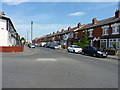
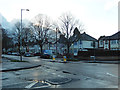
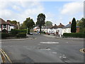
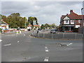
B11 3PW lies within Hall Green North Ward, a suburban district in southeast Birmingham known for its safe environment and historical character. The area’s small residential cluster accommodates 2,148 residents, many of whom live in early twentieth-century homes set back from tree-lined streets. The median age of 22 may reflect a mix of younger residents, but the most common age range is adults aged 30–64, suggesting a stable community. Predominantly Asian households own 66% of homes, with properties ranging from interwar villas to later infill developments. Daily life here balances quiet residential charm with practical connectivity, including nearby shops, rail links, and a primary school with a good Ofsted rating. The area’s blend of heritage and modernity—such as Petersfield Court’s Art Deco flats—offers a distinct character, while low crime rates and minimal environmental risks make it appealing for families seeking a settled, low-stress lifestyle.
- Area Type
- Postcode
- Area Size
- Not available
- Population
- 2148
- Population Density
- 5062 people/km²
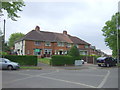
B11 3PW is predominantly an owner-occupied area, with 66% of homes owned by residents rather than rented. The accommodation type is primarily houses, reflecting a focus on family-friendly properties. This contrasts with areas dominated by rental flats, suggesting a more established, long-term resident base. The housing stock includes early twentieth-century villas, interwar developments, and later infill homes, offering a range of architectural styles. Notable examples include Petersfield Court, an Art Deco housing block from 1937, and The Hamlet, a Victorian-era development with distinctive brick and tile features. The small size of the area means the housing market is limited, but buyers may find a mix of characterful homes and newer properties. Given the high home ownership rate, the area is likely to appeal to those seeking stability and a sense of community over speculative investment.
House Prices in B11 3PW
No properties found in this postcode.
Energy Efficiency in B11 3PW
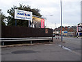
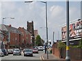
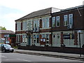
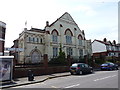
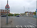
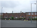
B11 3PW’s lifestyle is shaped by its mix of retail, transport, and historical sites. Nearby shops include Asda Sparkhill, Lidl Acocks, and Asda Merestones, offering everyday essentials within easy reach. The area’s historical character is evident in landmarks such as the Church of the Ascension (1704), a classical stone building, and the Friends Meeting House (1883), a red-brick Victorian structure. These sites, along with Hall Green Junior School, contribute to a sense of heritage and community. The presence of rail and metro stations ensures convenient access to Birmingham’s cultural and commercial hubs. While the data does not specify parks or leisure facilities, the tree-lined streets and historic buildings suggest a peaceful, well-maintained environment. This blend of practical amenities and historical charm makes daily life in B11 3PW both functional and enriched by its past.
Amenities
Schools
The nearest school to B11 3PW is Al-Furqan Primary School, which holds a good Ofsted rating. This primary school serves the local community, offering education for younger children within walking distance of many homes. While no secondary schools are listed in the data, families may need to consider nearby districts for secondary education. The presence of a well-rated primary school is a key draw for families, supporting the area’s reputation as a safe, family-oriented neighbourhood. The school’s good rating indicates quality teaching and facilities, which aligns with the broader context of Hall Green’s historical and cultural significance, including its proximity to the Friends Meeting House and Hall Green Junior School, which dates to 1893.
| Rank | School | Type | Entry gender | Ages |
|---|
Explore more schools in this area
Go to Schools tabDemographics
B11 3PW’s population of 2,148 includes a median age of 22, though the most common age group is adults aged 30–64, indicating a mature, stable community. Home ownership stands at 66%, with the majority of properties being houses rather than flats, reflecting a preference for family homes. The predominant ethnic group is Asian_total, shaping the area’s cultural fabric. This demographic profile suggests a mix of long-term residents and younger professionals, with a strong emphasis on homeownership. The low proportion of deprived households—implied by the absence of specific deprivation data—supports a quality of life characterised by stability and access to amenities. The presence of historical buildings and tree-lined streets complements the community’s sense of continuity, while the area’s safety and connectivity further enhance its appeal.
Household Size
Accommodation Type
Tenure
Ethnic Group
Religion
Household Composition
Age
Household Deprivation
NS-SEC
Explore more demographic insights in this area
Go to Demographics tabPlanning
Planning Constraints
- Flood RiskPremium
- Ramsar Wetland SitesPremium
- Area of Outstanding Natural BeautyPremium
- Protected Nature ReservePremium
- Protected WoodlandPremium