Area Overview for B11 3EQ
Photos of B11 3EQ
Area Information
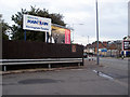
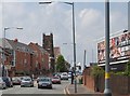
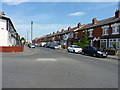
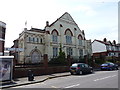
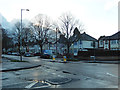
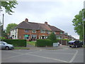
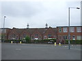
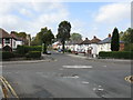
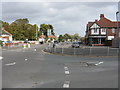
Living in B11 3EQ means inhabiting a small, tightly knit residential cluster in Birmingham’s Hall Green North Ward, a district renowned for its safety and historical character. With a population of 2,148, this area blends early 20th-century architecture with modern convenience. Streets feature low red brick walls, tree-lined avenues, and properties from the interwar period, many set back from roads in well-kept gardens. The ward’s reputation as one of Birmingham’s safest districts is reinforced by its low crime risk score of 68/100 and absence of environmental constraints like flood zones or protected landscapes. Daily life here balances suburban tranquillity with proximity to Birmingham’s urban amenities. Residents benefit from nearby retail hubs, rail links, and cultural landmarks such as the 1704 Church of the Ascension and the Victorian Friends Meeting House. The area’s appeal lies in its stable community, strong sense of place, and the mix of heritage and practicality that makes it ideal for families and professionals alike.
- Area Type
- Postcode
- Area Size
- Not available
- Population
- 2148
- Population Density
- 5062 people/km²
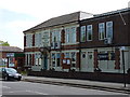
The property market in B11 3EQ is characterised by a 66% home ownership rate, with houses forming the majority of the housing stock. This suggests a community of long-term residents rather than a transient rental market. The area’s architecture reflects its history, with properties dating from the early 20th century, interwar period, and later infill developments. These include red-brick villas with leaded casements, such as those in the Hamlet development, and Art Deco blocks like Petersfield Court. For buyers, this means a mix of characterful homes with potential for renovation or investment. However, the small area’s limited size means the housing stock is not extensive, and proximity to Birmingham’s urban core offers additional options for those seeking larger properties or alternative locations. The emphasis on owner-occupation indicates a stable market, though the lack of detailed price data means specific investment risks remain unclear.
House Prices in B11 3EQ
No properties found in this postcode.
Energy Efficiency in B11 3EQ
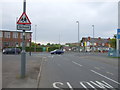
Life in B11 3EQ is enriched by a mix of retail, transport, and historical landmarks. Nearby shops such as Asda Sparkhill and Lidl Acocks provide essential groceries, while the area’s rail and metro stations—Spring Road, Tyseley, and Hall Green—connect residents to Birmingham’s business and cultural hubs. The district’s character is defined by its tree-lined streets and heritage sites, including the 1704 Church of the Ascension and the Victorian Friends Meeting House. These landmarks contribute to a sense of history and community identity. Parks and open spaces are not explicitly detailed, but the well-kept residential environment suggests accessible greenery. The blend of practical amenities and historical charm creates a lifestyle that balances modern convenience with a strong sense of place, appealing to those who value both comfort and character.
Amenities
Schools
The nearest school to B11 3EQ is Al-Furqan Primary School, which holds a good Ofsted rating. This institution serves the local community with a focus on primary education, though no secondary schools are listed in the data. The presence of a well-rated primary school is a key draw for families, ensuring access to quality early education. However, the absence of secondary school data means parents may need to consider nearby areas for secondary schooling. The school’s rating reflects the area’s commitment to education, aligning with Hall Green’s reputation as a family-friendly district. For those prioritising schools, B11 3EQ’s proximity to Al-Furqan Primary offers a practical advantage, though further research would be needed to confirm the full range of educational options available.
| Rank | A + A* % | School | Type | Entry gender | Ages |
|---|---|---|---|---|---|
| 1 | N/A | Al-Furqan Primary School | primary | N/A | N/A |
Explore more schools in this area
Go to Schools tabDemographics
B11 3EQ’s population of 2,148 is predominantly adults aged 30–64, reflecting a mature, established community. The median age of 22 is notably lower, suggesting a significant presence of younger residents, possibly students or professionals in their early careers. Home ownership stands at 66%, with houses being the primary accommodation type, indicating a mix of long-term residents and owner-occupiers. The predominant ethnic group is Asian, though specific proportions are not detailed. This demographic profile shapes a community with strong family ties and a focus on stability. The low claimant count unemployment rate, compared to the city average, suggests economic resilience. However, the absence of detailed deprivation data means the full picture of socioeconomic conditions remains unexplored. For residents, this translates to a neighbourhood where community cohesion and property investment are key features.
Household Size
Accommodation Type
Tenure
Ethnic Group
Religion
Household Composition
Age
Household Deprivation
NS-SEC
Explore more demographic insights in this area
Go to Demographics tabPlanning
Planning Constraints
- Flood RiskLocked
- Ramsar Wetland SitesLocked
- Area of Outstanding Natural BeautyLocked
- Protected Nature ReserveLocked
- Protected WoodlandLocked
- Crime RiskLocked