Area Overview for B11 3DQ
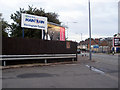
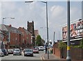
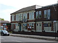
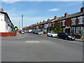
Photos of B11 3DQ
Area Information
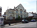
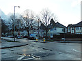
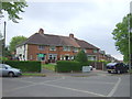
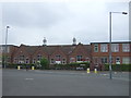
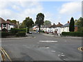
B11 3DQ lies within Hall Green North Ward, a suburban district in southeast Birmingham known for its safe environment and historical character. With a population of 2148, this small postcode area is a compact residential cluster, predominantly composed of houses built in the early twentieth century and interwar periods. The area’s tree-lined streets and low red brick boundary walls reflect its heritage, while modern amenities ensure convenience. Hall Green is part of Birmingham’s safer districts, with employment rates slightly above the city average and lower unemployment. Daily life here blends quiet suburban living with proximity to retail, transport, and cultural landmarks. The presence of historic buildings like the Church of the Ascension (1704) and the Friends Meeting House (1883) adds to its distinct charm. For homebuyers, B11 3DQ offers a balance of tradition and practicality, with easy access to rail and metro networks, making it ideal for commuters and families seeking a stable, community-oriented environment.
- Area Type
- Postcode
- Area Size
- Not available
- Population
- 2148
- Population Density
- 5062 people/km²
The property market in B11 3DQ is characterised by a high rate of home ownership (66%) and a focus on houses rather than flats, reflecting a predominantly owner-occupied area. This suggests a market geared toward families and long-term residents, with properties typically offering more space and private outdoor areas. The housing stock includes early twentieth-century and interwar-era homes, many of which are set back from roads with well-kept gardens. While the area is small, its proximity to Birmingham’s broader Hall Green district may offer additional options for buyers seeking similar properties. The absence of major planning constraints, such as protected woodlands or AONB designations, means development is unlikely to disrupt the existing character of the neighbourhood. For buyers, this presents an opportunity to invest in a stable, historically rich area with strong community ties and practical amenities.
House Prices in B11 3DQ
No properties found in this postcode.
Energy Efficiency in B11 3DQ
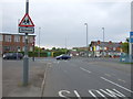
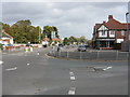
Living in B11 3DQ offers a blend of suburban tranquillity and accessible amenities. Nearby retail options include Asda Sparkhill, Lidl Acocks, and Asda Merestones, providing essential shopping within walking distance. The area’s proximity to rail and metro stations ensures easy access to Birmingham’s cultural and commercial hubs. Historically significant sites, such as the Church of the Ascension (1704) and the Friends Meeting House (1883), add character to daily life, while Petersfield Court, an Art Deco housing block, reflects the district’s architectural diversity. Parks and green spaces, though not explicitly named in the data, are implied by the area’s tree-lined streets and well-planted surroundings. This combination of practicality and heritage creates a lifestyle that is both convenient and enriched by the past, appealing to those who value community and history.
Amenities
Schools
The nearest school to B11 3DQ is Al-Furqan Primary School, which holds a good Ofsted rating. This school serves the local community with a focus on primary education, catering to children aged 4–11. While no secondary schools are listed in the data, the presence of a well-rated primary school is a significant draw for families. The area’s historical schools, such as Hall Green Junior School (1893), further underscore its long-standing educational infrastructure. The mix of school types—primarily primary—means parents may need to consider secondary education options in nearby areas, though the quality of primary schooling in B11 3DQ is strong. For families prioritising early education, the availability of a good primary school within walking distance enhances the area’s appeal.
| Rank | School | Type | Entry gender | Ages |
|---|
Explore more schools in this area
Go to Schools tabDemographics
The population of B11 3DQ is 2148, with a median age of 22, though the most common age range is adults aged 30–64. This suggests a mix of younger residents and a larger proportion of middle-aged households. Home ownership stands at 66%, indicating a majority of residents live in their own homes, while 34% rent. The area is predominantly composed of houses, not flats, reflecting a family-oriented housing stock. The predominant ethnic group is Asian, though specific proportions are not detailed. The low median age contrasts with the adult demographic, potentially pointing to a younger workforce or student population. Despite this, the area’s safety and stability—evidenced by below-average crime rates—support a quality of life that appeals to a broad range of residents. The blend of historical architecture and modern connectivity ensures a community that is both rooted in tradition and adaptable to contemporary needs.
Household Size
Accommodation Type
Tenure
Ethnic Group
Religion
Household Composition
Age
Household Deprivation
NS-SEC
Explore more demographic insights in this area
Go to Demographics tabPlanning
Planning Constraints
- Flood RiskPremium
- Ramsar Wetland SitesPremium
- Area of Outstanding Natural BeautyPremium
- Protected Nature ReservePremium
- Protected WoodlandPremium