Area Overview for B11 1BQ
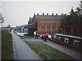
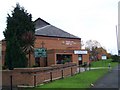
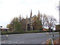
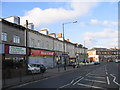
Photos of B11 1BQ


Area Information
Living in B11 1BQ means being part of a small, tightly knit residential cluster in Birmingham’s Sparkbrook and Balsall Heath East ward. With a population of 1,847 in this specific postcode, the area is part of a larger ward home to 27,338 residents, making it Birmingham’s second most populous electoral division. This area has a rich history as a hub for Commonwealth migrants since the 1960s, shaping its cultural diversity and community character. Despite challenges like high deprivation and unemployment, the ward thrives on entrepreneurial energy, with independent shops and cafes lining Stratford Road and Ladypool Road. Balsall Heath Park offers green space, while nearby retail and transport options provide practical convenience. The area’s mix of heritage and modernity, combined with a younger-than-average age profile, creates a dynamic environment where residents balance economic struggles with a strong sense of local identity. For buyers, B11 1BQ offers a snapshot of Birmingham’s complex urban fabric, where affordability meets cultural vibrancy.
- Area Type
- Postcode
- Area Size
- Not available
- Population
- 1847
- Population Density
- 4738 people/km²
The property market in B11 1BQ is dominated by owner-occupied houses, though home ownership is low at 29%, indicating a strong rental presence. This suggests a mix of private and rented housing stock, with houses being the primary accommodation type. Given the area’s small size and limited housing supply, buyers should consider the broader Birmingham context, where property values are influenced by proximity to transport and amenities. The low home ownership rate may reflect economic challenges, with many residents relying on rental markets or shared living arrangements. For buyers, the focus on houses implies a preference for family homes, though the limited stock means competition is likely. The area’s affordability, combined with its proximity to retail and transport, may appeal to those prioritising location over property size. However, the ward’s deprivation status could impact long-term investment potential.
House Prices in B11 1BQ
Showing 5 properties
| Address | Type | Beds | Baths | Last Sale Price | Last Sale Date | |
|---|---|---|---|---|---|---|
| 69 Stratford Street North, Birmingham, B11 1BQ | warehouse | - | - | - | - | |
| Midland Refrigeration, 67 Stratford Street North, Birmingham, B11 1BQ | warehouse | - | - | - | - | |
| 65 Stratford Street North, Birmingham, B11 1BQ | warehouse | - | - | - | - | |
| 63 Stratford Street North, Birmingham, B11 1BQ | warehouse | - | - | - | - | |
| 61 Stratford Street North, Birmingham, B11 1BQ | warehouse | - | - | - | - |
Energy Efficiency in B11 1BQ
Residents of B11 1BQ have access to a range of amenities within practical reach. The retail sector includes Spar City, Aldi Sparkbrook, and Iceland Birmingham, offering everyday shopping convenience. Nearby rail stations and metro stops, such as Bordesley and Corporation Street, provide efficient transport options for commuting or leisure. While specific parks are not named, Balsall Heath Park is a local landmark, offering green space for recreation. The area’s character is defined by its independent retail hubs along Stratford Road and Ladypool Road, where small businesses thrive. This mix of practical amenities and community-focused spaces supports a lifestyle that balances convenience with local identity. The proximity to multiple transport nodes and shops ensures daily life is efficient, though the area’s economic challenges may limit access to higher-end services.
Amenities
Schools
B11 1BQ is served by three schools, each offering distinct educational options. Christ Church CofE Controlled Primary School and Nursery is a primary school with an outstanding Ofsted rating, indicating high-quality teaching and facilities. R.Y.A.N Education Academy, a special school, holds a good Ofsted rating, catering to students with specific needs. Camp Hill Education, an independent school, has a satisfactory rating, reflecting its private sector approach. This mix of state and independent institutions provides families with choices, from mainstream education to specialised support. The presence of an outstanding primary school is a significant draw, though the independent school’s rating suggests it may not match the highest standards. Parents should consider the specific needs of their children when evaluating these options, as the area’s schools vary in focus and resources.
| Rank | School | Type | Entry gender | Ages |
|---|
Explore more schools in this area
Go to Schools tabDemographics
B11 1BQ has a median age of 47, with the majority of residents aged 30–64. Home ownership here is low at 29%, suggesting a rental-dominated market, while the predominant accommodation type is houses. The ward’s demographic profile is defined by its high proportion of Asian residents, reflecting its historical role as a destination for Commonwealth migrants. This diversity continues to shape the area’s character, though it also faces significant deprivation. As Birmingham’s most deprived ward, it has the eighth-highest child poverty rate among the city’s 69 wards. This context influences quality of life, with limited access to high-paying jobs and underinvestment in infrastructure. Despite these challenges, the community remains active, with small businesses and cultural institutions anchoring daily life. The age profile and household composition suggest a population focused on stability, though economic pressures persist.
Household Size
Accommodation Type
Tenure
Ethnic Group
Religion
Household Composition
Age
Household Deprivation
NS-SEC
Explore more demographic insights in this area
Go to Demographics tabPlanning
Planning Constraints
- Flood RiskPremium
- Ramsar Wetland SitesPremium
- Area of Outstanding Natural BeautyPremium
- Protected Nature ReservePremium
- Protected WoodlandPremium