Area Overview for B10 9NU
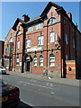
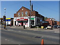
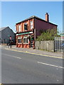
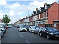
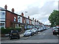
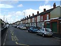
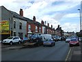
Photos of B10 9NU

Area Information
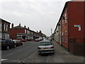
Living in B10 9NU, a small residential cluster in Birmingham’s Bordesley Green area, offers a blend of historical character and modern convenience. With a population of 2,419, this inner-city ward is centred around coordinates 52.470013, -1.872136, just two miles east of the city centre. The area’s origins trace back to 1285 as *La Grene de Bordeslei*, with urban development beginning in the 19th century. Notable features include the Ideal Village, a pioneering early 20th-century housing project designed by Barry Parker and Raymond Unwin, featuring low-density homes, a park, and a school. Daily life here is shaped by proximity to retail, rail, and metro links, with a community that values both historical preservation and practical living. The area’s small size means residents are close to amenities, while its history as a site of industrial activity and wartime resilience adds depth to its character.
- Area Type
- Postcode
- Area Size
- Not available
- Population
- 2419
- Population Density
- 18508 people/km²
The property market in B10 9NU is predominantly owner-occupied, with 73% of homes owned by residents rather than rented. The accommodation type is largely houses, which is unusual for an inner-city postcode but aligns with the area’s historical development, such as the Ideal Village’s low-density housing. This mix of older and newer properties suggests a market that caters to families seeking space and stability. The small size of the area means buyers must consider nearby neighborhoods for additional options, though the existing stock offers a range of homes. High home ownership rates indicate a community with long-term residents, which can be appealing for those seeking a settled environment. The presence of retail and transport links also supports the area’s desirability for both first-time buyers and those looking to downsize.
House Prices in B10 9NU
No properties found in this postcode.
Energy Efficiency in B10 9NU
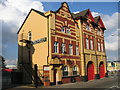
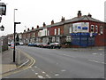
Daily life in B10 9NU is enriched by nearby amenities that cater to practical needs and leisure. Retail options include Asda Bordersley, Lidl Bordesley, and Morrisons Bordesley, offering a range of groceries and services. The area’s proximity to rail and metro stations, such as Adderley Park and Grand Central New Street, ensures easy access to Birmingham’s cultural and commercial centres. The Ideal Village, a historic development, includes shops, a park, and a school, fostering a sense of community. Residents can enjoy green spaces and local facilities, while the compact nature of the area means amenities are within walking or short-vehicle distance. This mix of retail, transport, and historical features creates a lifestyle that balances convenience with a connection to the area’s heritage.
Amenities
Schools
The nearest schools to B10 9NU include Marlborough Junior School, which operates as both a primary school and an academy. This dual designation offers families access to a single institution that combines traditional education with academy-style resources. The presence of a primary school within the area is a significant draw for families, as it reduces the need for long commutes. While no Ofsted ratings are provided, the existence of two entries for the same school suggests it may serve multiple age groups or have distinct departments. The Ideal Village’s original school, now potentially integrated into the current Marlborough Junior School, reflects the area’s long-standing commitment to education. This proximity to schooling is a key factor for families considering B10 9NU as a home.
| Rank | School | Type | Entry gender | Ages |
|---|
Explore more schools in this area
Go to Schools tabDemographics
B10 9NU has a median age of 22, though the most common age range for residents is 30–64 years. This suggests a mix of younger and middle-aged adults, with 73% of households owning their homes. The predominant accommodation type is houses, reflecting a residential area with a focus on family living. The dominant ethnic group is the Asian community, which shapes the cultural fabric of the ward. With a population of 2,419, the area is compact yet diverse, offering a sense of community within a small geographic footprint. Home ownership rates are notably high, indicating stability and long-term residency for many. The absence of specific deprivation data means quality of life is inferred from amenities and safety metrics, which suggest a balanced environment for families and individuals alike.
Household Size
Accommodation Type
Tenure
Ethnic Group
Religion
Household Composition
Age
Household Deprivation
NS-SEC
Explore more demographic insights in this area
Go to Demographics tabPlanning
Planning Constraints
- Flood RiskPremium
- Ramsar Wetland SitesPremium
- Area of Outstanding Natural BeautyPremium
- Protected Nature ReservePremium
- Protected WoodlandPremium