Area Overview for B10 9EW
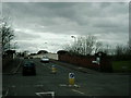
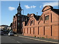
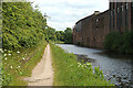
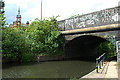
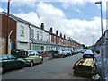
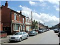
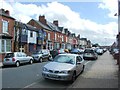
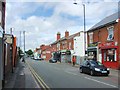
Photos of B10 9EW
Area Information
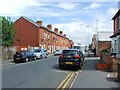
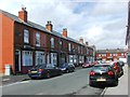
B10 9EW is a small residential postcode area in Birmingham’s West Midlands, centred around historic heathland turned 19th-century terraced housing. With a population of 2,683, it reflects a blend of urban living and historical character. The area’s origins as grazing land and its later development into a working-class neighbourhood shaped its current identity, marked by diverse communities from Ireland, Pakistan, India, and the West Indies. Daily life here is defined by proximity to transport links, retail, and schools, with a mix of terraced homes and community hubs. The area’s compact size means amenities are within practical reach, while its location near the Grand Union Canal and historic railway routes adds to its connectivity. Though small, B10 9EW offers a distinct blend of residential stability and cultural diversity, making it a microcosm of Birmingham’s broader urban fabric.
- Area Type
- Postcode
- Area Size
- Not available
- Population
- 2683
- Population Density
- 11545 people/km²
The property market in B10 9EW is characterised by a 47% home ownership rate, with houses forming the predominant accommodation type. This suggests a mix of owner-occupied and rental properties, though the small area size means housing stock is limited. Terraced housing, developed from the 19th century onwards, defines much of the built environment, offering compact, urban living. For buyers, this means a focus on individual homes rather than larger estates or apartments. The area’s proximity to transport links and amenities may make it attractive to those seeking affordable, centrally located properties. However, the small postcode area and limited housing supply could restrict availability, requiring buyers to consider nearby zones for more options.
House Prices in B10 9EW
No properties found in this postcode.
Energy Efficiency in B10 9EW
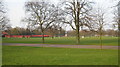
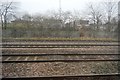
Residents of B10 9EW enjoy a range of amenities within walking or short driving distance. Retail options include major supermarkets like Morrisons Bordesley, Iceland Birmingham, and Asda Bordesley, ensuring convenience for daily shopping. The area’s transport links—rail and metro stations—connect to Birmingham’s cultural and commercial centres. While specific parks or leisure facilities are not detailed in the data, the proximity to historic sites like the former Birmingham Small Arms factory and local churches suggests a mix of heritage and community spaces. The blend of retail, transport, and historical sites contributes to a practical, connected lifestyle, ideal for those prioritising accessibility over expansive green spaces.
Amenities
Schools
Residents of B10 9EW have access to two notable schools. Somerville Primary (NC) School is a state-funded primary school with a Good Ofsted rating, providing education for younger children. Nearby, Darul Uloom Islamic High School is an independent institution with a Good Ofsted rating, catering to older students. The combination of a state primary and an independent secondary offers families flexibility in education choices. The presence of both school types reflects the area’s diverse community, with options ranging from mainstream state education to faith-based independent schooling. Parents seeking a mix of affordability and specialist provision may find this balance particularly appealing.
| Rank | School | Type | Entry gender | Ages |
|---|
Explore more schools in this area
Go to Schools tabDemographics
B10 9EW has a median age of 22, but the most common age range among residents is 30–64 years, indicating a mix of younger and middle-aged populations. Home ownership here is 47%, suggesting a significant proportion of households rent. The area is dominated by houses, though the exact distribution of household types is not specified. The predominant ethnic group is Asian (total), reflecting historical immigration patterns, particularly from Pakistan, India, and the West Indies. This demographic profile shapes a community with strong cultural ties and a focus on family-oriented living. While the area’s younger median age might suggest a transient population, the presence of established families in the 30–64 age bracket indicates stability. The relatively low home ownership rate could imply a rental market influenced by local employment opportunities and housing supply constraints.
Household Size
Accommodation Type
Tenure
Ethnic Group
Religion
Household Composition
Age
Household Deprivation
NS-SEC
Explore more demographic insights in this area
Go to Demographics tabPlanning
Planning Constraints
- Flood RiskPremium
- Ramsar Wetland SitesPremium
- Area of Outstanding Natural BeautyPremium
- Protected Nature ReservePremium
- Protected WoodlandPremium