Area Overview for B10 9AX
Photos of B10 9AX


Area Information
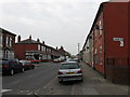
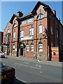
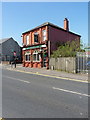
Living in B10 9AX means settling into a specific postcode area covering a small residential cluster within the urban inner-city ward of Small Heath, Birmingham. This ward, located in the West Midlands region, is centred around the transition from historical heathland to densely populated housing. The area's landscape was originally defined as narrow heath between Green Lane and Coventry Road, historically used for grazing on glacial drift land suitable for such purposes since Roman times. Victorian development reshaped this geography in 1834, introducing large houses for the wealthy followed by extensive terraced estates for industrial workers. You will find the ground here characterised by 19th-century housing developed from the mid-1800s onwards. The land records show a population of 3,378 residents calling this specific cluster home. The area lies on the historic route between Birmingham and Coventry, running parallel to the Grand Union Canal, which opened in 1799 as the Warwick and Birmingham Canal. Closeness to this transport lifeline has long influenced daily life, as the Birmingham and Oxford Junction Railway opened in 1852 to serve the growing community. Picadilly Place, the public house on Highfield Road, remains a local landmark visible within this residential environment. The modern experience of residing here involves navigating a military heritage site, the former home of the Birmingham Small Arms factory. Now functioning as a business park, the old industrial footprint has shifted from manufacturing bicycles and guns to corporate offices. Yet, the residential heart of B10 9AX retains its 18th-century domestic scale while benefiting from infrastructure built over two centuries ago.
- Area Type
- Postcode
- Area Size
- Not available
- Population
- 3378
- Population Density
- 14134 people/km²
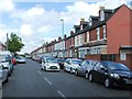
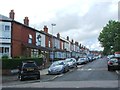
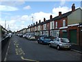
Homes in B10 9AX are primarily houses, as the prevailing accommodation type confirmed for this postcode area. This suggests a streetscape defined by terraced and semi-detached properties rather than the high-rise blocks often found in other parts of Birmingham. The area sustains a home ownership rate of 57 per cent, indicating that the majority of residents own their properties. This high level of ownership typically implies a stable, established neighbourhood where residents have long-term ties to their addresses. The housing stock consists largely of 19th-century terraced houses. These properties line the streets that were developed from the mid-Victorian era onwards. The physical layout of the area includes the Industrial Estate on Golden Hillock Road and Armoury Road, which stands on the former site of the Birmingham Small Arms factory. This industrial past has shaped the building landscape, resulting in large, solid homes that were originally constructed to house factory workers and later their families. For buyers scouting this small area, the prevalence of houses rather than flats is a defining characteristic. The 57 per cent ownership figure suggests that selling prices in B10 9AX may reflect the stability of an owned community. While the median age of 22 is low, the core household age of 30 to 64 years supports a demand for family-sized homes. The architecture remains consistent with the area's history, offering traditional brick-built properties. This combination of housing types and ownership levels makes B10 9AX distinct from newer housing estates or purely private rental sectors found elsewhere in the city.
House Prices in B10 9AX
No properties found in this postcode.
Energy Efficiency in B10 9AX
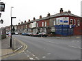
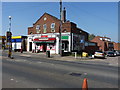
Living in B10 9AX offers immediate access to major retail destinations and transport hubs without needing to travel far. You have five significant retail options nearby, including the Asda Bordersley supermarket and Lidl Bordesley, alongside the M&S Birmingham branch. These stores provide for everyday grocery and shopping needs. The area also features five nearby railway stations, such as Small Heath Railway Station and Adderley Park Railway Station, facilitating easy travel. Additionally, five Metro stations lie within practical reach, including the Grand Central New Street stop, allowing quick access across the city. Your leisure options include local pubs like the Industrial Estate on Golden Hillock Road and the public house on Highfield Road. The history of the area shines through landmarks such as the old factory site now used as a business park, and the nearby Muntz Street stadium, which served as the home for Birmingham City FC until 1943. You might find yourself walking near historic churches, such as St Aidan, consecrated in 1894, or the Coventry Road Baptist chapel, established in 1891. For those who enjoy nature, the historic path between Green Lane and Coventry Road offers a glimpse of the original landscape. The proximity to the Grand Union Canal provides scenic routes for walking or cycling. The commercial and transport infrastructure is dense enough to support a self-sufficient lifestyle. Residents can combine a trip to the Lidl with sights of the old BSA business park in one afternoon. This mix of convenience and history defines the day-to-day experience for anyone homes in B10 9AX.
Amenities
Schools
| Rank | School | Type | Entry gender | Ages |
|---|
Explore more schools in this area
Go to Schools tabDemographics
The community profile for B10 9AX reveals a population with a median age of 22 years. While the median suggests a very young demographic, the most common age range occupies the Adults (30-64 years) bracket. This distribution indicates a mix of young families and established residents living together within the same streets. The area maintains a household ownership level of 57 per cent, meaning slightly more than half of the residents own their homes outright or through mortgage. The prevailing form of accommodation is Houses, distinguishing B10 9AX from parts of Birmingham dominated by high-rise flats or converted tenements. You will encounter a significant degree of cultural diversity, particularly because the Asian Total ethnic group comprises the predominant ethnicity in this postcode. This reflects the historic intake of Irish immigrants in the late 19th century, followed post-World War II by Pakistani, Indian, and West Indian communities. The local population is deeply rooted in the area's history, having settled in what was once a grazing heath. Specific data points show that the Asian demographic forms the largest single grouping, a fact confirmed by local census records for Small Heath. The home ownership statistic of 57 per cent indicates a stable market where a majority of residents have invested in their property rather than renting. The age structure, with a median of 22 alongside the 30-64 core group, suggests a neighbourhood where children grow up alongside professional workers. These figures paint a picture of a resilient community that has weathered industrial shifts and demographic changes since the 19th century.
Household Size
Accommodation Type
Tenure
Ethnic Group
Religion
Household Composition
Age
Household Deprivation
NS-SEC
Explore more demographic insights in this area
Go to Demographics tabPlanning
Planning Constraints
- Flood RiskPremium
- Ramsar Wetland SitesPremium
- Area of Outstanding Natural BeautyPremium
- Protected Nature ReservePremium
- Protected WoodlandPremium