Area Overview for B10 0XT
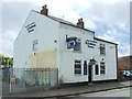
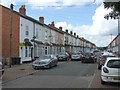
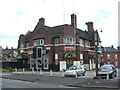
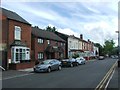
Photos of B10 0XT

Area Information
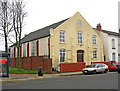
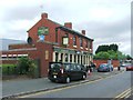
Living in B10 0XT means residing within the Bordesley Green electoral ward, a specific postcode cluster located approximately two miles east of Birmingham city centre. This residential area forms part of the West Midlands region, centred around coordinates 52.470013, -1.872136. With a population of 1899, the ward represents a concentrated community rather than a sprawling suburb. The local landscape is defined by its deep historical roots, originally mentioned in 1285 as La Grene de Bordeslei from an ancient demesne pasture. Although urban development in the area began in 1834 and expanded eastwards by 1906, the suburb retains significant character from its early 20th-century heritage. The Ideal Village, constructed between 1908 and 1914 by architects Barry Parker and Raymond Unwin, stands as a notable feature, offering lower-density housing and dedicated green space. Residents of B10 0XT also live near St Paul's Church, which began as a mission in 1912 and became a parish church in 1929. The history of this locality includes heavy impact during the Second World War, having suffered five Blitz raids including the last German bomb dropped on Birmingham on 24 April 1943. Despite these historical challenges, the area remains a functional inner-city neighbourhood with a strong sense of local identity shaped by its unique development and industrial past.
- Area Type
- Postcode
- Area Size
- Not available
- Population
- 1899
- Population Density
- 5465 people/km²
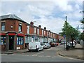
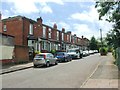
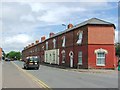
Homes in B10 0XT are primarily housed in residential clusters typical of an inner-city ward. The accommodation type leans heavily towards Houses, distinguishing the stock from the high-rise flats common in other Birmingham districts. Only 28 per cent of residents own their homes, implying that rental properties dominate the local market. This high rental proportion suggests a dynamic property environment where buying may be less prevalent than renting, or where property values pose significant entry barriers for first-time buyers looking at this small area. The physical layout includes surviving examples of early 20th-century development, such as the Ideal Village, which features Daniels Road and Finnemore Road. These roads commemorate the architects and developers who shaped the local housing character. For prospective buyers, the combination of a low ownership rate and a focus on houses indicates a market where traditional family homes are present but may represent a minority of the total inventory. The area does not feature luxury developments or prestigious estates; instead, it offers a straightforward stock of domestic housing rooted in the planning ideas of Barry Parker and Unwin. Understanding this structure is vital for anyone considering purchasing a residence here, as the market dynamics differ from more homeowner-heavy suburbs.
House Prices in B10 0XT
No properties found in this postcode.
Energy Efficiency in B10 0XT
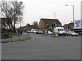
Daily life in B10 0XT is supported by a network of amenities located within practical reach of residents. Retail options are concentrated around key locations, with five notable stores nearby including Morrisons Bordesley, Iceland Birmingham, and Spar City. These supermarkets provide essential shopping needs close to your home. Transport links are integrated into your daily routine, with five railway stations and five metro stops nearby. Bordesley Railway Station, Small Heath Railway Station, and Adderley Park Railway Station serve the street-level transport needs. Commuters can also access the Underground via Corporation Street, Bull Street, and Grand Central New Street. Beyond shopping and transit, the area offers historic local features such as the surviving early 20th-century fire station and police station, located in Belchers Lane and Finnemore Road. The Ideal Village, with its roads named Daniels Road and Finnemore Road, retains its shops and park, contributing to the local character. St Paul's Church community project in these streets adds a social and cultural dimension to the neighbourhood. Residents enjoy a blend of essential retail, efficient public transport, and preserved historic spaces that define the everyday experience of living in this ward.
Amenities
Schools
Living in B10 0XT places residents within practical commuting distance of several educational institutions serving different needs. The area is home to Regents Park Community Primary School, which holds an Ofsted rating of good and caters to younger learners. Parents seeking private education options have access to Eddie School of Accountancy and Green Heath School. Green Heath School also carries a good Ofsted rating, ensuring maintained standards in the independent sector. Oakwood School (BIETTEC) operates as an independent institution, providing further choice for families opting out of the state system. For children with special educational needs, Blue River Academy serves as a special school within the immediate vicinity. This mix of state and independent provision, alongside special needs coverage, means the 1899 residents of this ward have diverse educational pathways available. The presence of multiple independent schools suggests a local economy with the capacity to support private education. Families considering moving to this postcode can rely on a range of options without needing to travel far for schooling. The variety ensures that whether you require a good-rated primary school or a specific secondary education, the local supply meets distinct requirements without geographical barriers.
| Rank | School | Type | Entry gender | Ages |
|---|
Explore more schools in this area
Go to Schools tabDemographics
The community within B10 0XT is characterised by a mature demographic profile with a median age of 47 years. Adults aged between 30 and 64 years represent the most common age range in this ward, suggesting a population heavily weighted towards those in their middle years. Home ownership in the immediate vicinity stands at 28 per cent, which indicates that the majority of households are tenants rather than owners. This lower rate of ownership often reflects the local housing stock composition and the financial accessibility of homes in this specific postcode area. Employment and professional diversity are visible through the presence of independent schools like Eden School of Accountancy and Oakwood School, alongside the notable history of manufacturing industries such as the production of HANDEL nuclear warning equipment in the 1960s. The predominant ethnic group in the area identifies as Asian, contributing to a culturally diverse environment. While specific data on deprivation is not provided in the current statistics, the demographic mix points to a working-class and artisan heritage, particularly influenced by the design philosophy of the Ideal Village intended for artisan workers. Families and long-term residents likely form the backbone of this social structure, navigating life in a ward that balances historical significance with modern urban living.
Household Size
Accommodation Type
Tenure
Ethnic Group
Religion
Household Composition
Age
Household Deprivation
NS-SEC
Explore more demographic insights in this area
Go to Demographics tabPlanning
Planning Constraints
- Flood RiskPremium
- Ramsar Wetland SitesPremium
- Area of Outstanding Natural BeautyPremium
- Protected Nature ReservePremium
- Protected WoodlandPremium