Area Overview for B10 0XJ
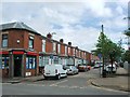
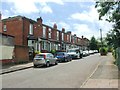
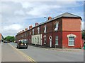
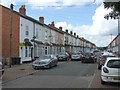
Photos of B10 0XJ


Area Information
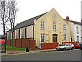
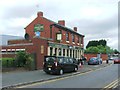
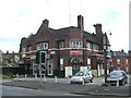
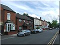
B10 0XJ lies within Bordesley Green, a small residential cluster in Birmingham’s Eastside, approximately two miles from the city centre. With a population of 1,930, it is a compact area shaped by 19th-century urban expansion and early 20th-century developments like the Ideal Village, a pioneering low-density housing scheme. The area’s character is defined by its mix of historic infrastructure, such as the surviving fire station and St Paul’s Church, alongside modern amenities. Daily life here is influenced by its proximity to transport networks, including multiple railway stations and metro stops, which connect residents to Birmingham’s broader economy. The community is diverse, with the Asian population forming the predominant ethnic group, and a median age of 22 suggesting a younger demographic. However, the most common age range is 30–64, indicating a balance between families and working-age residents. Living here means navigating a tight-knit, inner-city environment with a focus on practicality, where the area’s historical roots meet contemporary needs.
- Area Type
- Postcode
- Area Size
- Not available
- Population
- 1930
- Population Density
- 5177 people/km²
The property market in B10 0XJ is characterised by a low home ownership rate of 25%, suggesting that the area is largely a rental market. The accommodation type is predominantly houses, which is atypical for inner-city postcodes but reflects the legacy of the Ideal Village’s 1908–1914 development. This mix of housing stock implies a focus on family-friendly, low-density living, though the small area’s size means the market is limited in scope. For buyers, this suggests a niche environment where properties are likely to be owner-occupied by a minority and rented out by the majority. The limited number of homes may also mean competition for available properties, particularly for those seeking larger, traditional housing. The area’s proximity to transport links and schools could offset its smaller scale, but buyers should consider the rental market’s dominance when evaluating long-term value or investment potential.
House Prices in B10 0XJ
No properties found in this postcode.
Energy Efficiency in B10 0XJ
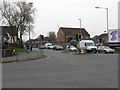
The lifestyle in B10 0XJ is shaped by its proximity to retail, transport, and historical landmarks. Nearby amenities include supermarkets such as Morrisons Bordesley, Iceland Birmingham, and Asda Bordesley, providing convenient shopping options. The area’s railway stations and metro stops—Bordesley, Small Heath, and Adderley Park, plus Corporation Street and Grand Central New Street—ensure easy access to Birmingham’s wider offerings. Historically, the Ideal Village’s legacy persists through its low-density housing, parks, and community spaces, while St Paul’s Church and its associated projects add a cultural dimension. For daily life, the mix of retail, transport, and green spaces supports both practical needs and a sense of community. The area’s compact size means amenities are within practical reach, though residents may need to travel further for specialist services. The blend of historic and modern elements creates a distinctive character, appealing to those who value accessibility and heritage.
Amenities
Schools
Residents of B10 0XJ have access to several primary schools, including Wyndcliffe Junior Community School, Wyndcliffe Infant School, Small Heath School, Wyndcliffe Primary School, and Greenfields Primary School. The latter is an independent school with a ‘good’ Ofsted rating, offering a contrast to the state-funded options. The mix of school types provides families with choices, from free state education to fee-paying alternatives. Greenfields’ independent status may appeal to parents seeking specific educational approaches, though its ‘good’ rating indicates it meets standards. The presence of multiple primary schools suggests a focus on early education, which is crucial for families with young children. However, the data does not include secondary schools, so parents may need to look beyond the immediate area for comprehensive schooling. The availability of both state and independent options reflects the area’s diversity and its appeal to a range of household needs.
| Rank | School | Type | Entry gender | Ages |
|---|
Explore more schools in this area
Go to Schools tabDemographics
The population of B10 0XJ is 1,930, with a median age of 22, though the most common age range is 30–64 years. This suggests a community where younger individuals coexist with a larger proportion of working-age adults. Home ownership is low at 25%, indicating that the area is predominantly a rental market. The accommodation type is primarily houses, which is unusual for inner-city areas but aligns with the Ideal Village’s legacy of low-density housing. The predominant ethnic group is the Asian community, reflecting broader demographic trends in Birmingham. The low home ownership rate may influence local dynamics, with fewer long-term residents and a higher turnover of tenants. For quality of life, this could mean a more transient community, though the presence of schools and amenities suggests efforts to support families. The data does not indicate deprivation levels, but the mix of age groups and housing types implies a balance between affordability and stability.
Household Size
Accommodation Type
Tenure
Ethnic Group
Religion
Household Composition
Age
Household Deprivation
NS-SEC
Explore more demographic insights in this area
Go to Demographics tabPlanning
Planning Constraints
- Flood RiskPremium
- Ramsar Wetland SitesPremium
- Area of Outstanding Natural BeautyPremium
- Protected Nature ReservePremium
- Protected WoodlandPremium