Area Overview for B10 0UR
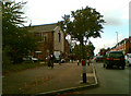
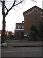
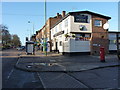
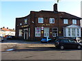
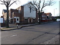
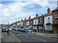
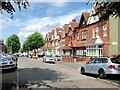
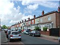
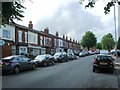
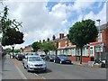
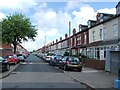
Photos of B10 0UR

Area Information
Living in B10 0UR means inhabiting a small, defined postcode area within Birmingham’s Small Heath ward, a historically significant urban district shaped by 19th-century terraced housing. With a population of 1,981, this compact cluster of homes sits on former heathland, now characterised by a mix of older residential architecture and modern infrastructure. The area’s proximity to key transport routes, including the Grand Union Canal and historic railway lines, reflects its role as a commuter hub. Daily life here is influenced by its diverse community, with a strong presence of South Asian heritage from post-war migration. The area’s compact size means amenities are within practical reach, though its small footprint limits housing diversity. Residents benefit from a blend of urban convenience and historical context, with landmarks like the former Birmingham Small Arms factory site nearby. For buyers, B10 0UR offers a snapshot of Birmingham’s industrial past and multicultural present, though its limited size means proximity to broader city amenities is key.
- Area Type
- Postcode
- Area Size
- Not available
- Population
- 1981
- Population Density
- 9146 people/km²
B10 0UR’s property market is defined by its 65% home ownership rate and a focus on houses, which contrasts with the typical terraced housing of Small Heath. This suggests a mix of owner-occupied homes and rental properties, though the area’s small size limits housing diversity. The presence of 19th-century terraced housing, developed during Victorian industrial expansion, indicates older stock that may require renovation or adaptation. For buyers, the compact postcode area means competition for properties is concentrated, with limited scope for new builds. Proximity to transport links, including rail and metro stations, enhances the appeal of homes here, particularly for commuters. However, the area’s small footprint means buyers should consider nearby zones for more housing options. The predominance of houses over flats or apartments also suggests a preference for family-oriented living, aligning with the demographic profile of working-age adults and established households.
House Prices in B10 0UR
No properties found in this postcode.
Energy Efficiency in B10 0UR
The lifestyle in B10 0UR is shaped by its proximity to retail, transport, and historical sites. Nearby shops include Iceland Heybarnes, Asda Small, and Lidl Yardley, offering everyday convenience for residents. The area’s transport network, with rail and metro stations, connects it to Birmingham’s commercial and cultural hubs. While the data does not specify parks or leisure facilities, the area’s historical context—such as the former BSA factory site and Muntz Street stadium—adds a layer of local interest. The mix of retail and transport options suggests a practical, commuter-focused lifestyle, ideal for those prioritising accessibility over expansive green spaces. The compact nature of the area means amenities are within walking or short transit distance, though residents may need to venture further for larger recreational facilities. This blend of urban convenience and historical legacy defines daily life in B10 0UR.
Amenities
Schools
The nearest school to B10 0UR is St Benedict’s Primary School, a primary institution with a ‘good’ Ofsted rating. This single primary school serves the immediate area, though families may need to look further afield for secondary education. The absence of listed secondary schools in the data implies reliance on nearby districts for comprehensive schooling. The presence of a ‘good’ rated primary school is a positive indicator for families, offering a baseline of educational quality. However, the lack of additional schools in the immediate vicinity may necessitate travel for older children, which should be factored into a family’s decision-making process. The school’s rating suggests a focus on foundational education, but parents should investigate broader options in surrounding areas for a full range of educational needs.
| Rank | School | Type | Entry gender | Ages |
|---|
Explore more schools in this area
Go to Schools tabDemographics
B10 0UR’s population of 1,981 is predominantly composed of adults aged 30–64, with a median age of 22, suggesting a working-age demographic skewed towards families and professionals. Home ownership rates stand at 65%, with houses being the primary accommodation type, indicating a mix of owner-occupied properties and rentals. The area’s predominant ethnic group is Asian_total, reflecting historical migration patterns, particularly from South Asia. This demographic profile shapes the community’s character, with cultural influences evident in local businesses and social networks. The absence of specific deprivation data means quality of life is inferred from infrastructure and services, which include schools, transport, and retail. The age range suggests a stable population with established households, though the relatively low median age may indicate a younger workforce or student population. This mix of demographics and ownership structures creates a dynamic but tightly knit residential environment.
Household Size
Accommodation Type
Tenure
Ethnic Group
Religion
Household Composition
Age
Household Deprivation
NS-SEC
Explore more demographic insights in this area
Go to Demographics tabPlanning
Planning Constraints
- Flood RiskPremium
- Ramsar Wetland SitesPremium
- Area of Outstanding Natural BeautyPremium
- Protected Nature ReservePremium
- Protected WoodlandPremium