Area Overview for B10 0QG
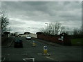
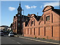
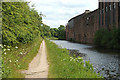
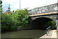
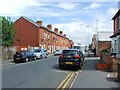
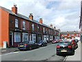
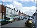
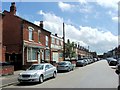
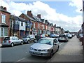
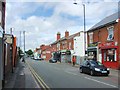
Photos of B10 0QG


Area Information
B10 0QG is a small residential cluster in Birmingham’s Bordesley Green area, home to just 1,899 people. Nestled two miles east of the city centre, it lies within the West Midlands, centred on coordinates 52.470013, -1.872136. The area’s history dates back to 1285, when it was known as *La Grene de Bordeslei*, a medieval pasture. By the 19th century, urban development expanded, and the Ideal Village — England’s first purpose-built community for artisans — was constructed between 1908 and 1914. This historic character persists today, with surviving early 20th-century structures like a former fire station and police station now repurposed as a hostel. Living here means being part of a tight-knit, low-density neighbourhood with a mix of heritage and modern infrastructure. The area’s proximity to rail and metro networks, along with nearby schools and retail hubs, makes it accessible yet distinct. However, its small size means the community is closely knit, with a focus on local amenities rather than sprawling urban sprawl.
- Area Type
- Postcode
- Area Size
- Not available
- Population
- 1899
- Population Density
- 5465 people/km²
B10 0QG’s property market is characterised by a low home ownership rate of 28%, which contrasts with the predominance of houses as the primary accommodation type. This suggests a rental market where properties are more likely to be leased than owned, possibly due to the area’s small size and limited housing stock. The presence of houses rather than flats or apartments indicates a focus on traditional, low-density housing, which may appeal to families or those seeking more space. However, the low ownership rate means the market is less stable for long-term investment, with fewer buyers looking to purchase for residency. For those considering the area, the limited number of properties available could mean higher competition among renters. The small scale of B10 0QG also means that property values and availability are closely tied to the broader Bordesley Green ward, which has a mix of historic and modern developments.
House Prices in B10 0QG
No properties found in this postcode.
Energy Efficiency in B10 0QG
Daily life in B10 0QG is shaped by its proximity to retail, dining, and transport hubs. Within practical reach are five retail outlets, including Morrisons Bordesley, Iceland Birmingham, and Spar City, offering a range of grocery and convenience shopping options. The area’s rail and metro stations — Small Heath, Bordesley, and Adderley Park — provide direct links to Birmingham’s business and cultural centres, while metro stops like Corporation Street and Bull Street connect to the city’s broader transport network. Although the area is small, its density of amenities ensures residents have access to essentials without long commutes. The presence of the Ideal Village, with its historic shops, park, and school, adds a distinct character to the neighbourhood. For leisure, nearby green spaces and community projects, such as St Paul’s Church initiatives, offer social and recreational opportunities. This blend of practicality and heritage creates a lifestyle that balances convenience with a sense of local identity.
Amenities
Schools
Residents of B10 0QG have access to a range of educational institutions, from primary schools to independent academies. Regents Park Community Primary School is a state-funded primary school with a good Ofsted rating, offering a reliable option for younger children. Green Heath School is an independent school also rated good, while Eden School of Accountancy and Oakwood School (BIETTEC) provide specialist education in accountancy and other fields. Blue River Academy is a special needs school, ensuring comprehensive coverage for diverse educational needs. The mix of school types — state, independent, and special — reflects the area’s varied demographics and priorities. Families seeking state education can rely on the good-rated primary schools, while those preferring independent or specialist institutions have options nearby. The presence of multiple schools within practical reach supports the area’s appeal to households with children, though the small postcode size means choices are limited to immediate surroundings.
| Rank | School | Type | Entry gender | Ages |
|---|
Explore more schools in this area
Go to Schools tabDemographics
The population of B10 0QG is 1,899, with a median age of 47, indicating a mature demographic. The most common age range is adults aged 30–64, suggesting a mix of working professionals and families. Home ownership here is notably low at 28%, implying a rental-dominated market. The predominant accommodation type is houses, which is unusual for a city-centre postcode, pointing to a blend of older, detached properties and newer developments. The area’s ethnic composition is dominated by the Asian community, reflecting broader trends in Birmingham’s diversity. This demographic profile shapes daily life: older residents may prioritise stability and proximity to services, while the rental market suggests a transient element. The low home ownership rate also means fewer long-term residents, influencing the area’s social dynamics. For buyers, this data highlights a market skewed toward short-term tenancies rather than investment in property.
Household Size
Accommodation Type
Tenure
Ethnic Group
Religion
Household Composition
Age
Household Deprivation
NS-SEC
Explore more demographic insights in this area
Go to Demographics tabPlanning
Planning Constraints
- Flood RiskPremium
- Ramsar Wetland SitesPremium
- Area of Outstanding Natural BeautyPremium
- Protected Nature ReservePremium
- Protected WoodlandPremium