Area Overview for B10 0JW
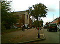
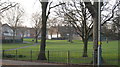
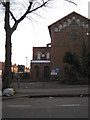
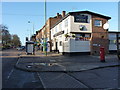
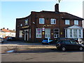
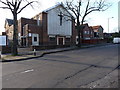
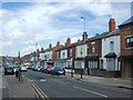
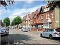
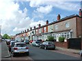
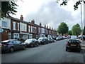
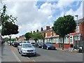
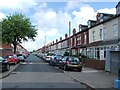
Photos of B10 0JW
Area Information
Living in B10 0JW, a small residential cluster in Birmingham, means inhabiting a historically significant urban area shaped by 19th-century terraced housing and a legacy of industrial activity. With a population of 1,979, the area is compact yet rich in character, centred around former heathland that once supported grazing. Its proximity to the Grand Union Canal and historic railways reflects its role as a transport hub between Birmingham and Coventry. The community is diverse, with roots in Irish, Pakistani, Indian, and West Indian communities, creating a vibrant cultural mix. Daily life here is defined by convenience: nearby rail and metro stations provide easy access to the city, while local shops and amenities cater to everyday needs. The area’s blend of historic architecture and modern infrastructure makes it appealing for those seeking a balance between tradition and practicality. For buyers, B10 0JW offers a snapshot of inner-city living with a distinct identity, though its small size means the immediate surroundings are crucial for accessing broader services.
- Area Type
- Postcode
- Area Size
- Not available
- Population
- 1979
- Population Density
- 12994 people/km²
The property market in B10 0JW is characterised by a 48% home ownership rate, suggesting that nearly half of properties are owner-occupied, while the remaining 52% are likely rented. The accommodation type is predominantly houses, which is notable for a small postcode area, implying a focus on terraced or semi-detached housing developed during the 19th century. This mix of historic and traditional properties may appeal to buyers seeking characterful homes, though the limited size of the area means the immediate surroundings are critical for housing options. The relatively low home ownership rate could indicate a rental market dominated by private landlords or social housing providers. For buyers, the scarcity of data on property prices or availability means focusing on the area’s architectural heritage and proximity to transport links. However, the small footprint of B10 0JW means that nearby areas, such as adjacent wards or Birmingham’s broader suburbs, may need to be considered for a comprehensive housing search.
House Prices in B10 0JW
No properties found in this postcode.
Energy Efficiency in B10 0JW
The lifestyle in B10 0JW is shaped by its proximity to retail, rail, and metro amenities. Local shops include Asda Small, Iceland Heybarnes, and Asda Bordersley, offering everyday essentials within walking distance. The five nearby railway stations and three metro stops provide seamless access to Birmingham’s wider network, making commuting efficient for workers in the city or surrounding areas. While the area lacks dedicated parks or leisure facilities within its boundaries, its historic character includes sites like the former BSA factory, now a business park, which adds to its industrial heritage. The compact nature of B10 0JW means that residents must venture slightly beyond the postcode for larger recreational spaces, but the availability of transport options ensures these are accessible. The blend of retail convenience and transport links supports a practical, urban lifestyle, though those prioritising green spaces may need to look further afield.
Amenities
Schools
The nearest school to B10 0JW is Holy Family Catholic Primary School, a primary institution with an Ofsted rating of ‘good’. This school serves the local community, offering education for younger children in a setting that aligns with Catholic values. The absence of secondary schools in the immediate vicinity means families may need to look to nearby areas for secondary education, such as those within a 5–10 kilometre radius. The presence of a single primary school with a strong rating suggests that the area is well-served for early education but may lack diversity in school types. This could be a consideration for families requiring specialist provisions or a broader range of educational philosophies. Parents should assess the commuting distance to secondary schools and the availability of private or independent options in the surrounding region.
| Rank | School | Type | Entry gender | Ages |
|---|
Explore more schools in this area
Go to Schools tabDemographics
The demographic profile of B10 0JW reveals a community where adults aged 30–64 form the most common age group, despite a median age of 22. This suggests a mix of established residents and younger families, though the latter may be transient. Home ownership stands at 48%, indicating a moderate balance between owner-occupied properties and rental stock. The predominant accommodation type is houses, which is unusual for a compact postcode area, suggesting a mix of larger terraced homes and smaller family units. The dominant ethnic group is Asian_total, reflecting historical immigration patterns, particularly from Pakistan, India, and the West Indies. This diversity influences local culture, with community spaces and traditions shaped by these groups. However, the data does not specify deprivation levels, so assumptions about quality of life must be made cautiously. The presence of a strong working-age population may support local services but could also indicate a need for targeted community amenities.
Household Size
Accommodation Type
Tenure
Ethnic Group
Religion
Household Composition
Age
Household Deprivation
NS-SEC
Explore more demographic insights in this area
Go to Demographics tabPlanning
Planning Constraints
- Flood RiskPremium
- Ramsar Wetland SitesPremium
- Area of Outstanding Natural BeautyPremium
- Protected Nature ReservePremium
- Protected WoodlandPremium