Area Overview for B10 0HN
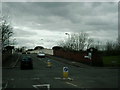
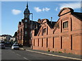
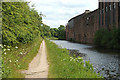
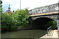
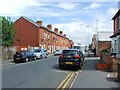
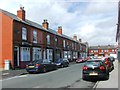
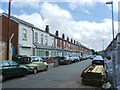
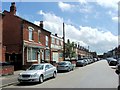
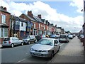
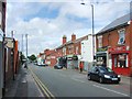
Photos of B10 0HN


Area Information
Living in B10 0HN, part of Bordesley Green in Birmingham, means being part of a small, tightly knit residential cluster just two miles east of the city centre. With a population of 1,854, it’s a compact area shaped by over a century of urban development. The name “Bordesley Green” itself reflects its origins as a demesne pasture, later transformed into a residential hub. Today, it balances historical character with modern infrastructure. The area’s proximity to Birmingham’s core offers easy access to the city’s cultural and economic heart, while its small-scale nature fosters a sense of community. The presence of the Ideal Village, a pioneering early 20th-century housing project, adds architectural and social heritage. Despite its size, B10 0HN is served by multiple rail and metro stations, ensuring connectivity. Its residents, predominantly adults aged 30–64, benefit from a mix of retail, transport, and green spaces, though the area’s compactness means every amenity is within walking or cycling distance.
- Area Type
- Postcode
- Area Size
- Not available
- Population
- 1854
- Population Density
- 17343 people/km²
The property market in B10 0HN is defined by its 40% home ownership rate, which indicates a significant portion of the housing stock is rented. This suggests a dynamic market where both buyers and renters coexist, though the small area size may limit the availability of properties. The accommodation type is predominantly houses, which is unusual for a city-centre postcode and may appeal to families seeking more space. The presence of houses rather than flats implies a focus on semi-detached or terraced homes, which are common in older residential areas like Bordesley Green. For buyers, this means competition could be fierce due to the area’s limited housing stock, but the proximity to Birmingham’s amenities and transport links may justify higher prices. The mix of ownership and rental properties also means potential buyers should consider long-term trends in local demand and development.
House Prices in B10 0HN
No properties found in this postcode.
Energy Efficiency in B10 0HN
Daily life in B10 0HN is shaped by its proximity to essential amenities. Within practical reach are five retail outlets, including Morrisons Bordesley, Iceland Birmingham, and Asda Small, providing convenience for grocery shopping. The area’s historical roots are visible in landmarks like the Ideal Village, which features a park, school, and low-density housing. St Paul’s Church and its community projects in Belchers Lane and Finnemore Road add a social and cultural dimension. While the data does not list specific dining or leisure venues, the presence of retail and green spaces suggests a lifestyle that balances practicality with community engagement. The compact nature of the area means residents can walk to most amenities, fostering a sense of accessibility. The mix of historical and modern elements ensures a unique character, though the small size may limit options for those seeking specialized services.
Amenities
Schools
| Rank | School | Type | Entry gender | Ages |
|---|
Explore more schools in this area
Go to Schools tabDemographics
B10 0HN’s population of 1,854 is predominantly adults aged 30–64, with a median age of 22—a reflection of the area’s mix of long-term residents and younger professionals. Home ownership stands at 40%, suggesting a balance between owner-occupied properties and rental units. The accommodation type is primarily houses, which is notable in a city-centre postcode, indicating a focus on family-friendly housing. The predominant ethnic group is Asian, highlighting the area’s cultural diversity. While no specific deprivation data is provided, the demographic profile suggests a community with established roots and a blend of generational presence. The age range implies a stable population, with families and working-age adults forming the core. This mix supports local amenities and services, though the small population size means the area operates on a smaller scale compared to larger urban districts.
Household Size
Accommodation Type
Tenure
Ethnic Group
Religion
Household Composition
Age
Household Deprivation
NS-SEC
Explore more demographic insights in this area
Go to Demographics tabPlanning
Planning Constraints
- Flood RiskPremium
- Ramsar Wetland SitesPremium
- Area of Outstanding Natural BeautyPremium
- Protected Nature ReservePremium
- Protected WoodlandPremium