Area Overview for B10 0AT
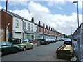
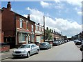
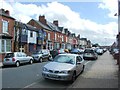
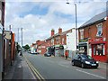
Photos of B10 0AT
Area Information
Living in B10 0AT means inhabiting a small, densely populated residential cluster in Birmingham’s Sparkbrook and Balsall Heath East ward. With a population of 1,779, this urban area is defined by its cultural diversity, shaped by post-1960s migration from the Commonwealth. The community is predominantly Asian, with a median age of 22, though the most common age range is 30–64 years. Daily life here is characterised by a mix of small businesses along Stratford Road and Ladypool Road, community hubs, and a strong sense of local identity. However, the area faces challenges: it is Birmingham’s most deprived ward, with the eighth-highest child poverty rate. Despite this, residents benefit from proximity to Balsall Heath Park and a range of amenities, including independent shops and schools. The area’s history as an industrial and cultural hub continues to influence its vibrant, though economically strained, present.
- Area Type
- Postcode
- Area Size
- Not available
- Population
- 1779
- Population Density
- 3006 people/km²
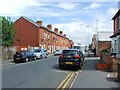
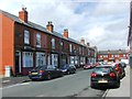
The property market in B10 0AT is dominated by owner-occupied homes, though home ownership is relatively low at 39%, suggesting a significant rental market. Houses, rather than flats, are the primary accommodation type, reflecting a traditional housing stock. This mix implies limited availability of newer developments, which may affect property prices and buyer competition. For buyers, the small area’s housing stock is constrained, with limited scope for expansion. Proximity to Stratford Road and Ladypool Road’s commercial hubs may offer opportunities for investment in small businesses, but the area’s economic challenges could impact long-term value. Potential buyers should consider the balance between affordability and the need for infrastructure improvements.
House Prices in B10 0AT
No properties found in this postcode.
Energy Efficiency in B10 0AT
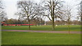
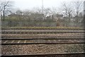
Life in B10 0AT is shaped by its proximity to Stratford Road and Ladypool Road, commercial hubs lined with independent shops and small businesses. Retailers such as Aldi Sparkbrook and Spar City offer everyday essentials, while the metro network provides access to Birmingham’s city centre. Balsall Heath Park is a key green space for leisure and recreation. The area’s cultural diversity is reflected in its food scene and community events. However, economic constraints mean that amenities are modest compared to wealthier parts of the city. Residents rely on nearby transport links and local shops, creating a self-contained but resource-limited lifestyle.
Amenities
Schools
B10 0AT is served by three schools, each with distinct roles. Holy Trinity Catholic School operates as both a primary school and an academy, both with Ofsted ratings of ‘good’. Hazrat Khadijatul Kubra Girls School is an independent school also rated ‘good’. This mix provides families with options between state and private education. The presence of a Catholic school and an independent institution reflects the area’s religious and cultural diversity. However, the absence of secondary schools nearby may require families to commute. The quality of education here is generally strong, though the ward’s economic challenges could affect resource allocation.
| Rank | School | Type | Entry gender | Ages |
|---|
Explore more schools in this area
Go to Schools tabDemographics
B10 0AT has a median age of 22, but the majority of residents fall within the 30–64 age range, reflecting a working-age population. Home ownership is low at 39%, with houses being the primary accommodation type. The predominant ethnic group is Asian_total, contributing to a culturally rich and diverse community. The ward’s deprivation levels are stark: it is Birmingham’s most deprived area, with child poverty rates among the city’s highest. This affects access to services and employment opportunities, though the area’s young population and entrepreneurial energy sustain local businesses. The high proportion of BAME residents and the presence of faith-based organisations and community hubs highlight a socially active population. However, economic challenges persist, with unemployment rates exceeding city averages.
Household Size
Accommodation Type
Tenure
Ethnic Group
Religion
Household Composition
Age
Household Deprivation
NS-SEC
Explore more demographic insights in this area
Go to Demographics tabPlanning
Planning Constraints
- Flood RiskPremium
- Ramsar Wetland SitesPremium
- Area of Outstanding Natural BeautyPremium
- Protected Nature ReservePremium
- Protected WoodlandPremium